Category Archives: Surveying
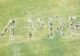
Geomatics STEM Outreach – NM State Prep Academy
Editor’s note: With all the talk among surveying and geospatial practitioners and the professional associations and societies about outreach, succession planning, and recruitment, it is great to see examples of action from across the country. Here is a great model for other state societies to emulate from New Mexico, courtesy of David Acosta, PS, president...
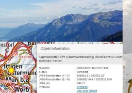
Surveyors Invited to Join Research Delegation
Land Surveyors and other geospatial professionals are being sought to join a delegation to Switzerland in September of 2018 to research models for cadastral systems. This is the first of an envisioned series of international delegations and exchanges seeking to foster a broader understanding of cadasters and cadastral systems within the surveying community. This is...
Lost My Rodman
On June 25th, I lost my rodman, who was also my brother, best friend, and only sibling, at the much-too-young age of 57. He went to sleep and didn’t wake up. Turns out he had been ignoring symptoms of heart trouble for some time, and, unfortunately, it was a fatal mistake. My weeks since have...

A Fine Line
Notes from a visit to the new production facility for Topcon and Sokkia optical surveying instruments. I asked Tsutomu Ishibashi, a production line technician at Topcon’s Yamagata manufacturing facility, what message he would like to convey to the surveyors who use the products he helps produce. His answer was, “We are always trying to improve,...

I-Shoku-Ju
A joint interview with Topcon president and CEO, Satoshi “Steve” Hirano, and Topcon Positioning Systems president and CEO, Ray O’Connor. I recently had an opportunity to sit down with Satoshi “Steve” Hirano, president and CEO of Topcon Corporation, for a candid interview at the company’s global headquarters (THQ) in Tokyo. The timing of this visit...
CORS Map
A First for Africa Geospatial professionals don’t need an introduction to CORS. For everyone else, it’s an acronym that stands for continuously operating reference systems: geodetic receivers that log GNSS observables continuously which, when transmitted to users with survey-grade receivers, help them achieve centimeter-accuracy measurements. CORS stations have a range of about 70 kilometers (~43...