
The new release of Autodesk Civil 3D includes the Connector for ArcGIS. An Esri-Autodesk partnership, launched in 2017, takes yet another big step, and one that should make a lot of civil design professionals very happy.
The sidelong glances, the flirting, the occasional dating … such has been the on-again/off-again relationship between these two giants in the AEC design and GIS worlds. But with the latest development, we can only conclude (yeeha!) that they are headed for a long-term commitment—or at least “friends with geospatial benefits.”
The Esri-Autodesk collaboration, launched in 2017, was met with great enthusiasm, as many practitioners in respective disciplines had been struggling with legacy barriers to CAD-GIS integration born of structural differences, and (at times) a bit of tension between companies and user communities. But no more. The partnership has already proved to be fruitful.
First steps included the Autodesk Connector for ArcGIS with Autodesk InfraWorks as the first product to incorporate features for live and seamless bi-directional GIS access and update.
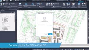
Connecting to Esri ArcGIS directly from inside Autodesk Civil 3D.
The partnership formed from a mutual recognition that the two worlds of AEC design and GIS were structurally different platforms, with different strengths, areas of expertise, and markets. But more important, that such collaboration was an imperative, a critical evolutionary step in infrastructure design, construction, and operations. This as the demands of global infrastructure development are now far exceeding the capacity of legacy workflows and the compartmentalization of geospatial data.
In This Release
The detail of the nee Civl 3D 2020.1 release, announced on September 4th, 2019 is best detailed in the following post by Autodesk’s Bobby del Rosario. There are other new features beyond CAD+GIS; this includes links to some informative videos. But I also asked Wes Newman, a technical marketing guy at Autodesk, about his insights on this latest development. Wes has a lot of hands-on user experience and was heavily involved in the recent ArcGIS+InfraWorks integration.
“Much of what we did, working closely with Esri for [integration] with InfraWorks served as a basis for what we have done with Civil 3D and Map 3D; a lot of the core code was done.” Said Newman. He explains the GIS-to-CAD workflow: “From inside Civil 3D and Map 3D you can connect to ArcGIS, log in to your account, and browse. And if an enterprise, like a city or county, is publishing public data sets, you can browse without a login,” says Newman, “With this [release] you can bring in GIS data [in the form of] cogo points, features, lines, alignments, parcels, and pipe networks.” And he noted that you can work with geodatabases. More will be added in future releases.
The CAD-to-GIS workflow allows you to add new feature layers to ArcGIS, but not individual entities yet, though you can edit and attribute or update a location. Newman says this is being looked at for future releases.
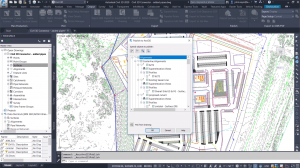
Publishing a pipe network to Esri ArcGIS from Autodesk Civil 3D
Many Steps Leading Us Here
CAD+GIS and GIS+CAD (had to flip a coin to side which I’d write first so as not to slight either side) is about removing the “sides” when it comes to AEC design/construction/operations. Being able to access broader contextual site and regional data and networks of utilities and transportation to inform civil design has always been a goal. And there have always been ways to get the data to and from GIS and CAD, mostly by import/export routines—mostly cumbersome and with compromises.
Decades ago, there was any early collaboration between Esri and Autodesk on ArcCAD. And for the DIY crowd, there were command line routines like SHP2DXF. As the roots of Civil 3D evolved from DCA to Softdesk Civil, to LDD, there were Autodesk MAP elements integrated. Users were hungry for GIS data in Civil design, and to be able to add, for instance, surveyed or as-built data into GIS.
Shapefiles often became the common currency. I still have scars from writing Avenue scripts for ArcView to clip out mini shapefiles from multiple themes, and a 14-page AutoLISP routine that would write a custom script each time to import them via “aeccmap” sub-routines as AutoCAD entities with attributes as extended entity data. There have been great improvements in the Map features for connection to GIS data, and some popular 3rd party geo-data “universal translators,” but nothing quite where we are now.
We’ll be reaching out to some users and taking new developments out for test drives, as the road to CAD+GIS nirvana will involve many steps to come, but in my view, this addition to Civil 3D is mighty big one.