With America, Russia, China, and the EU all now having GNSS constellations operating, what does it mean for surveyors and geospatial professionals?
By Nick Bearman
With the two newest Global Navigation Satellite Systems (GNSS) becoming operational (Galileo on December 15, 2016, and BeiDou on June 23, 2020), what does this mean for surveyors and geospatial professionals? GNSS/GPS is a vital tool for surveyors and all geospatial professionals (as well as many other industries and the public). So let’s explore what these two new satellite constellations can do for us.
What is GNSS (& GPS) and how does it work?
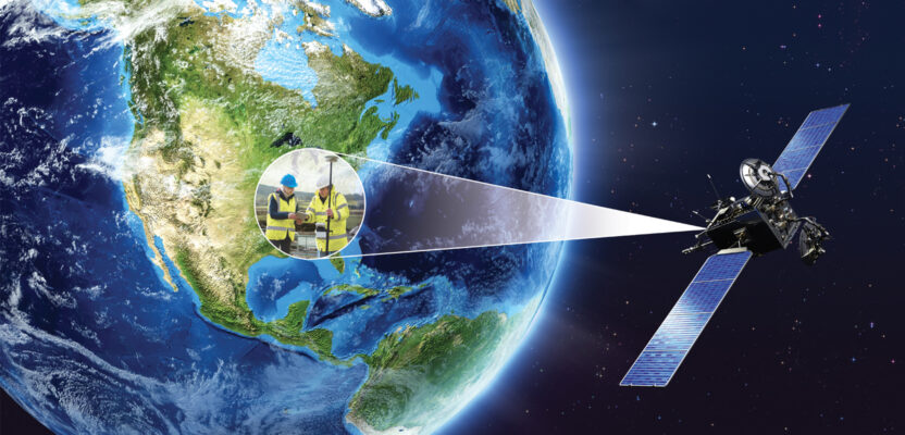
GPS is a term you know, and it allows us to know our location anywhere across the globe using a small, handheld battery-powered device. GPS underpins most consumer level sat-nav devices and is a key piece of kit in surveying, used to locate the user.
Formally, GPS is one system (Global Positioning System), which is run by the U.S. military. The general name for this technology is GNSS (Global Navigation Satellite Systems) and there are four main systems (or constellations) in use today: GPS (U.S.), GLONASS (Russia), BeiDou (China), and Galileo (European Union/European Space Agency).
When people say “GPS” they are usually referring to GNSS as a whole, rather than just GPS. Fundamentally, all four systems work in the same way: a series of satellites (up to 24 for each system) orbit the earth, emitting a very accurate (and precise) time signal. A user on the ground with a suitable receiver (standalone, built into a cell phone or built into another piece of kit) receives these signals. When receiving three (or more) of these signals, the receiver can work out where on the earth it is located.
We know where the satellites are and we know the distance the signal has traveled (based on the time difference from the other signals and calculated from the travel time, as the signals travel at the speed of light, a known constant). Using this information we can use trigonometry to calculate our location, to an accuracy from around 10 meters down to one or two centimeters or more. The accuracy we can achieve depends on how many signals the unit you are using receives, whether you have any local correction data, and how long you remain in one position.
For example, a cell phone or a handheld GPS unit, a five- to 10-meter accuracy is normal, with a professional GNSS station and some correctional data, one to two centimeters is easily achievable.
GPS and GLONASS: Military Origins
GPS has been fully operational at a global level since 1993, and the Russians (Soviet Union at the time) developed GLONASS along a similar timeframe. GLONASS only achieved regional coverage (12 satellites) by April 1991, with the Soviet Union breaking apart at the end of 1991. The Russian Federation took over operation and the system became fully operational in 1993, with global coverage.
The impact of the end of the Soviet Union was not felt by GLONASS until 1999 because of the long lead time in space projects, and the fact that the satellites were designed to operate for three years. Between 1991 and 2001, the system limped along as a result of underfunding and neglect. It deteriorated so much that only six satellites were operational by 2001.
With Russia’s economy improving, President Vladimir Putin took a special interest in GLONASS, prioritizing and funding the restoration of the full satellite constellation, with full global coverage being achieved in 2015. Both GPS and GLONASS are explicitly military systems, available for (respectively) the U.S. and Russia military usage, with civilian use added at a later stage.
Both programs still make use of encrypted signals for military-only use, with a higher level of accuracy. Another constraint for the open (public) signal was the use of selective availability, which intentionally degrades the public signals such that accuracy was reduced and variable, making it unsuitable for a lot of use cases, including surveying. Selective availability was permanently switched off for GPS in May 2000.
Since the mid-1990s a whole range of systems around the world have become much more dependent on accurate timing, which is often obtained from GPS. This timing is key to synchronizing communication systems across a whole range of devices, including television, radio, and the Internet.
There has also been much greater reliance on the positioning technology, both in commercial activities (including surveying) and use of these technologies by the general public (emergency services, navigation in cars, mobile phones, etc.).
Galileo and BeiDou
As a response to increasing reliance on GPS around the world, and the military focus of the existing systems, the European Union/European Space Agency (Galileo) and China (BeiDou) developed their own systems. Creating a new GNSS from scratch is not a small undertaking, with both systems taking about 20 years to be developed, manufactured, launched, tested, and made available. The EU’s Galileo system cost about €10 billion ($12 billion). Unsurprisingly, the Chinese haven’t said how much BeiDou cost, but it is likely to be a similar amount to Galileo.
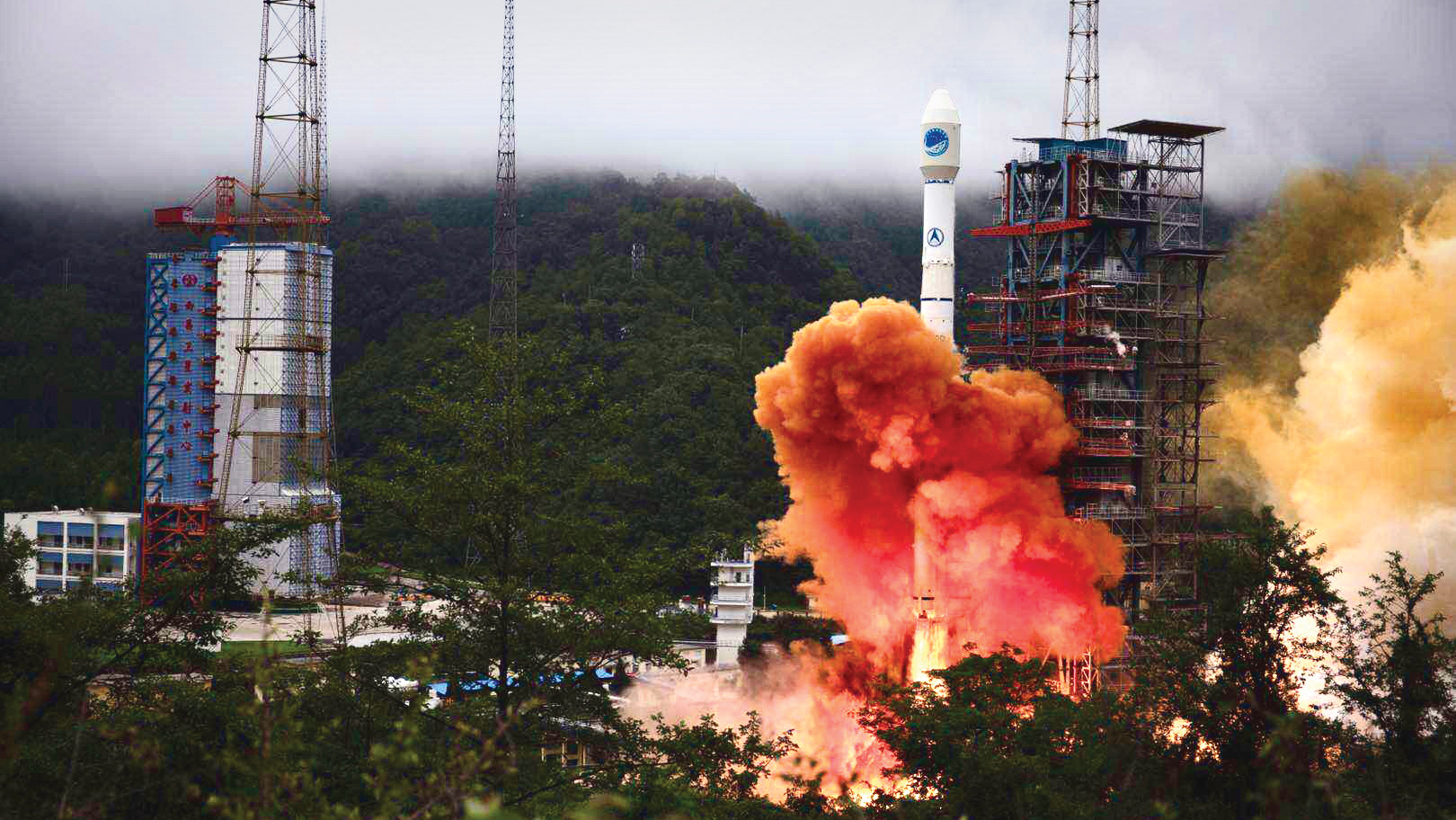
China launched the last satellite of its BeiDou Navigation System (BDS) from the Xichang Satellite Launch Center last June. Credit CGTN
As well as the additional features and benefits of the new systems (see below) there is almost as much political benefit as technological benefit for developing these independent systems, with independence from reliance on the U.S. system often cited as a reason.
Benefits for Surveyors and Geospatial Professionals
From a surveyor and location professional’s point of view, one of the big benefits of these new systems (constellations) is that there are many more satellites in orbit that can be used to get a location fix. Previously there where 24 GPS satellites around the globe, of which no more than 12 would be visible at any one point on the globe (assuming you have a clear view to the whole horizon, which of course you very rarely do). You would need to receive signals from three or four satellites to get a reasonable location fix (25 percent to 33 percent of the total number available).
With each system now having 24 satellites (96 in total) and with most professional surveying kit able to receive signals from all four systems, there is now a potential pool of 48 satellites visible at any one time, so you only need to get signals from six to eight percent of them to get a fix.
Speaking with Tim Burch, president-elect of the National Society of Professional Surveyors (NSPS), the big difference is that you can get a location fix using surveying kits much, much faster with these new constellations available. A process that could have taken two or three minutes now takes two or three seconds—incredibly valuable if you are surveying a site with hundreds or thousands of points that need to be recorded. A greater number of satellites can also result in higher levels of accuracy, and more reliability in the data collected.
While Galileo is run by the European Union, a non-military organization, the Galileo system still does have a highly accurate encrypted signal available for military use. It also offers a highly accurate commercial system (available at a cost) and a mid-level accuracy system (down to decimeters, sometimes called “shovel-width”) that was going to be available for a fee, but is now freely available.
This will be very valuable for the surveying industry and may well reduce the requirement for expensive RKT kits for some jobs. Galileo will also include a search and rescue feature that piggybacks on to the existing COSPAS-SARSAT rescue system, providing a return signal
to system users.
Brexit (the UK leaving the European Union) has thrown a spanner in the works for the UK users of Galileo, particularly for marine and aviation users who may not be able to access some of the services they were planning to. In addition, the UK armed forces may no longer have access to the military signal element. Discussions are on going, so a compromise may be achieved.
There was brief political discussion about the UK creating its own GNSS following its purchase of satellite communications OneWeb, however, the satellites OneWeb plans to run would not, in themselves, be capable of running a GNSS. Despite what the UK politicians say, the UK is not in a position to create its own GNSS at a cost of £8 billion to £10 billion over 10 years.
We will see what the negotiations with the EU about Galileo provide, and, mostly likely, the UK will have some access to Galileo in the end.
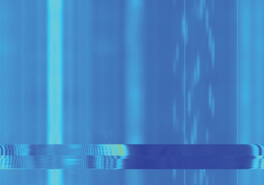
A spectrogram of GNSS radio waves with time on the y axis (up and down) and frequency on the x axis (left and right). The light blue band on the left is the GPS and Galileo signals, with difference satellites represented with different codes (CDMA, code division multiple access). On the right, the white patches at varying intervals are the different GLONASS satellites, which use different frequencies (FDMA, frequency division multiple access). GLONASS will update to CDMA to reduce the number of radio frequencies it needs to operate, vital in a very crowded radio frequency spectrum. The two horizontal lines across the bottom are a jamming signal, used in this case to disrupt GPS, GLONASS and Galileo.
Developments and Risks
Speaking with Steve Hancock, head of GNSS for Ordnance Survey, the national mapping agency for Great Britain, all four GNSS systems are developing all the time, with the GPS upgrade program providing many of the similar benefits of Galileo to GPS.
Hancock also pointed out that GNSS signal interference and jamming is a concern. While GNSS signals are very useful, they are also incredibly weak (imagine the power of a 60-watt light blub several thousand kilometers away). This, combined with the open nature of GNSS signals (which is great, as it means anyone can receive and understand them), makes it very easy for someone with the right knowledge to interfere with or fabricate these signals.
Andrew Salmon, product manager at Trimble, described how GNSS jamming can be a regular occurrence in some locations, which, while not maliciously aimed at surveyors, will potentially play havoc with their data collection. Some of their newer products include technology to receive data from a variety of frequencies and calculate the location based on the signals it receives, and discard any jammed signals, often automatically.
Hancock also pointed out that these systems are designed by humans, meaning they have the potential to suffer from human error. The potential for problems has not been well explored, and in 2016, a GPS timing problem had a knock-on effect on the UK’s digital radio signal.
There is also the potential for space weather to impact these services, with solar flares a particular issue. Solar flares have the potential to temporarily disrupt electrical systems across the globe. The sun has an 11-year cycle and it is due to reach its peak in this next cycle in 2025, meaning solar flares for the next few years will be more active.
While we have an idea of the sun’s cycle, the impact of these solar storms depends on whether they hit the earth, something we are not yet very good at predicting. The largest known event of this type in history is called the Carrington Event, which was a very powerful solar flare that took place on September 1 and 2, 1859.
When this hit the earth, telegraph systems all over Europe and North America failed, with some giving the operators electric shocks, and sparks seen coming from telegraph pylons. Some telegraph operators could continue to send and received messages, even while the systems were disconnected from their power supplies. If an event like this happened today, there would be widespread disruption, electrical blackouts, disruption to communications and radio frequencies (including GNSS), and potentially damage to satellites.
A similar magnitude event occurred in 2012, but fortunately passed the Earth’s orbit without hitting the planet. Many countries are now drawing up space-weather forecasting capabilities, forward planning, and backup plans in case a solar storm does hit—but our understanding is currently very limited, so we won’t really know what the impacts are until they happen.
Other GNSS Users
While there are a lot of exciting developments for professional users of GNSS, what about the general public? We have been benefiting from more accurate GPS signals on our mobile phones for some time now, and location is often of great interest to us.
Most GPS chips in phones are very cheap ($1 to $2) and quite power hungry to do location calculations. Therefore, the power is often restricted (to preserve battery life) and this impacts the accuracy of the location. While many phones can receive GLONASS, Galileo, and/or BeiDou signals as well as GPS, this is often quite limited because of power usage. Sports-watch producer Garmin even says if you want to improve the battery life of your watch, change from GPS + Galileo to just GPS.
Next Steps
Overall GNSS technology is moving fast, with more satellites, faster and more accurate fixes, and lots of other developments in the pipeline. Keep up with the developments in xyHt and use them to improve the speed and accuracy of your work.