July 2019 Archives
Accuracy with a Phone?

Photogrammetry is now possible using consumer devices, and the applications are vast. Continuing improvement in digital cameras—including those in cell phones—and in photogrammetry algorithms have enabled dozens of consumer and professional photogrammetric applications. Among the professional ones is PhotoModeler, which produces accurate maps, drawings, CAD data, 3D models, and photos draped on 3D models. Its […]
Dr. Gladys West

The quiet dedication of a hidden hero who made satellite geodesy and global positioning possible. As early as high school, the focused determination of Dr. Gladys West would see her rise to make key contributions to one of the most impactful scientific endeavors of our age. In our recent interview with xyHt magazine, West gave […]
Many Sensors for a Tulip Tree Map
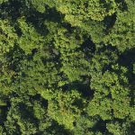
Above: The forests of Puerto Rico are second-growth, making for useful modeling. After hurricane deforestation in Puerto Rico, NASA scientists study forest regrowth using high-resolution, multi-sensor image data. The Biospheric Laboratory of the NASA Goddard Space Flight Center is dedicated to increasing knowledge about the Earth’s terrestrial ecosystem. One group of scientists there has been […]
Piping Hot Tech

Above: The cramped field conditions in the underground tunnels are evident in this point cloud Trammel used to create the 3D tunnel piping. From crowded boiler rooms to hard-to-reach underground tunnels, BIM experts tell us how following a smooth workflow is key to rapidly creating accurate 3D pipe models from point clouds. Inside the Student […]
Search for the Missing Pier

Above: The Gaithersburg Latitude Observatory is now a community park. My tale of locating the latitude pier of the Cincinnati Latitude Observatory, one of six international latitude observatories now defunct but historically significant. It was 1974, and I’d been working at the National Geodetic Survey (NGS) for two years. One afternoon my boss told me […]
The Enablers of GIS

The late Roger Tomlinson is credited with being the father of GIS, but, without the commercial success of Jack and Laura Dangermond’s company, Esri, GIS would never have touched our lives the way it has. This year Esri celebrates its 50th year, though you won’t find any huge announcements from them about it as Jack […]