Finally: the rationale for a new geometric geodetic reference frame to replace the North American Datum of 1983.
In 2008, the NGS released the publication of a ten-year operating plan that, among other things, called for efforts to replace NAD 83 and NAVD 88, the official horizontal and vertical geodetic datums of the United States. (Note that in addition to NAVD 88, the proposed plan would replace the official vertical datums of the various United States island areas of Hawaii, American Samoa, Guam, Northern Marianas, Puerto Rico, and the U.S. Virgin Islands.) This and a following article will examine the rationale behind these planned changes and the potential impact on horizontal positions, ellipsoid, and orthometric heights across the country. (See the sidebar on page 15 for the full names of all acronyms in this story, in their order of appearance.)
Leading to NAD 83
Since at least the mid-1960s, the USC&GS, renamed NGS in 1970, has been playing catch-up to developments in electronic measurement and positioning technology. The introduction of a cheap, easy-to-use EDMI by Hewlett Packard, the HP 3800, in 1971 finally put EDMI technology in the hands of many surveyors. Although EDMIs had been around since the late 1950s, they had generally been quite large and expensive, requiring specially trained operators, and were not useful for the needs of the average land surveyor. The HP 3800 dramatically changed all that. The modest cost and ease of operation of this instrument meant that for the first time local surveyors were able to perform distance measurements that were on par with those that could previously have been feasible only for surveys performed by federal geodetic surveying agencies such as USC&GS/NGS, the USGS, and the various Department of Defense, Army, and Air Force surveys. Significant advancements in electronic computing technology also allowed private surveyors to discover distortions in positions related to NAD 27. In addition, island areas of the United States such as Hawaii, American Samoa, Guam, Northern Marianas, Puerto Rico, and the U.S. Virgin Islands were defined by their own local horizontal datums that were not connected to NAD 27. Responding to these changes and to the nearly simultaneous development of the U.S. Navy’s Transit Doppler space-based positioning system ultimately led NGS to collaborate with the federal geodetic survey agencies of Canada and Mexico to undertake the development of a replacement datum, NAD 83.
This effort, which required nearly 10 years of intensive programming and data automation and hundreds of employee-years of technical support, led to several significant firsts. When it was finally released in mid-1986, NAD 83 was the first civilian horizontal datum anywhere to have the origin of the coordinate system defined as close to Earth geocenter as the technology would allow, rather than as a specific survey mark in the middle of a field somewhere. In addition, it was the first horizontal datum to use the recently adopted (1979) international standard ellipsoid GRS80, which was best fitting globally, as compared to the previously used Clarke 1866, which was best fitting just for North America.
NAD 83 was the first geodetic datum to have all of its supporting observations (directions, distances, astronomic azimuths, etc.) fully translated from the original paper records to digital form—approximately 1.8 million individual observations from the 19th and 20th centuries. Some of the nearly 250,000 stations within the United States extended their legacy to the original 1816-1817 New York City survey performed by the Survey of the Coast under the direction of the organization’s first superintendent Ferdinand Hassler, and that was just the portion for the United States.
It was also the first geodetic datum to have the data maintained in an electronic database and the first to be publically available over the Web (although that came years later). By incorporating observations from the Transit Doppler system and VLBI network, it was also the first to incorporate space-based observations.
Two important decisions made by NGS really stand out: the location of the origin of coordinates at Earth geocenter and the adoption of the GRS80 reference ellipsoid. No one at NGS in the late 1970s or early 1980s could fully appreciate how quickly and dramatically the recently launched NAVSTAR GPS would impact geodetic surveying efforts. What the NAD 83 team did know was that the future for positioning would be space-based and that the origin of the national coordinate system should, to the extent possible and practical, be directly coincidental with the Earth’s center of mass about which all satellites orbit.
Given the technologies of the time, the location of Earth geocenter was known to approximately 2 meters, an amazing technological feat at the time. Today, with the multitude of advances in GPS and other positioning technologies, the location of Earth geocenter is known to approximately 2-4 cm.
Challenges to NAD 83
Almost from the day NGS released the initial NAD 83 positions, now referenced as NAD 83 (1986), they were again forced to play technological catch-up. This time the cause was the rapid development of GPS. Having conducted the first operational GPS project in 1983, NGS soon abandoned classical triangulation as the primary means to establish horizontal geodetic control. In short order NGS and a few private companies that owned the original Macrometer V-1000 GPS receivers (costing approximately $250,000 each!) (Figure 1) noticed that there was residual distortion of slightly less than 1 m remaining in the original NAD 83 coordinates on a regional level.
This time NGS was faced with not just a readjustment of the original triangulation but the need to completely resurvey the country with GPS, because the technology exhibited a level of precision of measurement that far exceeded that which had been, and could be, generally accomplished by classical triangulation and traverse methods.
Beginning in 1989, NGS designed and conducted a nationwide survey effort commonly referred to as HPGN and/or HARN, working in partnership with state departments of transportation, other federal surveying and mapping agencies, and occasionally private surveyors who volunteered personnel and GPS equipment. Between 1989 and 1997, when the last HARN survey was completed, several major advancements in GPS technology and surveying methodology had occurred. These included:
- less expensive, easier-to-use hardware and processing software,
- significant improvements in computing the orbits of the satellites,
- a better understanding of the characteristics of the antenna electronic phase centers,
- development of networks of CORS, and
- methods to improve the vertical component.
By the time the last HARN (Indiana) was completed in 1997, it was already realized that these developments had been significant enough to warrant a second (and final) national resurvey, this time to focus on the improvement of the ellipsoid height component. This new effort was referred to as the FBN/CBN program and was completed in 2004. (For a variety of reasons, Alaska and Hawaii were not included in the resurvey.)
Subsequent to the completion of the FBN/CBN, NGS consolidated all the GPS data that had been submitted over the previous 21 years into a national adjustment that, when completed, was designated as the NAD 83 (2007). This was superseded in 2012 by the NAD 83 (2011), which is the current realization of NAD 83 and was necessitated by the completion by NGS in 2011 of the Multi-Year Solution of the CORS network.
The result of all of these efforts improved the horizontal component of the NSRS to approximately 1-3 cm for passive marks tied to the CORS. Given the accuracy of the reference frame, density of control stations (both CORS and passive marks), and access to the datum with tools such as OPUS, NAD 83 currently meets the needs of virtually all practical surveying, mapping, and charting applications. Note that all the improvements do not change the fact that the official datum is still the same.
Another factor is that NAD 83 is defined as the official horizontal datum of the United States as outlined in Federal Register Vol. 54, No. 113 #25318, June 14, 1989, and, with the exception of Alabama and Hawaii, all of the states have adopted specific state legislation or statutes defining NAD 83 as the preferred reference frame for local surveying and mapping activities. Getting states to modify existing legislation and statutes when they don’t have a problem with NAD 83 is probably a nonstarter. So why change?
Advancements in Global Coordinate Systems
 Previously, while developing the architecture of NAD 83, NGS understood that the future of positioning would be from space-based platforms, and, therefore, the origin of coordinates should be located as close to Earth geocenter as possible. Again, based on the technologies of the late ‘70s and early ‘80s, the general knowledge of the location of Earth geocenter at the time of the completion of NAD 83 (1986) was known to approximately 2 m. In 1988, two years after the release of NAD 83, the IERS (later renamed the International Earth Rotation and Reference System Service), was established, based in Paris, France. The mission of the IERS is to collaborate with institutions around the world to integrate several different space-based positioning and measurement systems to monitor Earth orientation parameters; these systems include GNSS, SLR, DORIS, and VLBI.
From these observations, IERS determines the Earth’s orientation parameters and describes them as the ITRS. This information is usually realized in a practical way as coordinates and three-dimensional velocities for individual stations that form the ITRF. Data from a subset of the CORS network managed by NGS is shared with IERS as part of the United States’ contribution to the continuing development and improvement of ITRF solutions. The first ITRF data set was released in 1988, and the most current is referenced as ITRF2008.
While the ITRF provides considerable information about the nature of the Earth’s orientation, for purposes of this discussion probably the most important aspect is an improved knowledge of the location of Earth geocenter to within about 3-4 cm. The ITRF is sometimes referred to as the “Gold Standard” for reference frames.
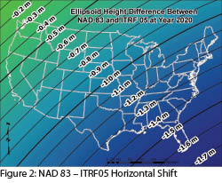
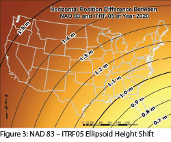 Consequently, NAD 83, despite all the internal improvements that have been made, is still defined to the original origin and exhibits a bias or offset to the ITRF of approximately 1 m each in the horizontal and ellipsoid height components in the conterminous United States (Figures 2 and 3). Elsewhere it exhibits average 3-dimensional positional differences of about 1.5 m in CONUS, 1.4 m in Alaska, 2.5 m in Hawaii, 3.1 m in American Samoa, 2.3 m in Guam and the Northern Marianas, and 1.9 m in Puerto Rico and the U.S. Virgin Islands.
These offsets are generally quite consistent for any given geographical area, and while they may be of considerable concern to those involved in geodetic and geophysical research and, perhaps, the FAA, they are of little or no real consequence to the vast majority of those using GPS for the large array of practical surveying, mapping, charting, and GIS applications. So why change?
Future Challenges to NAD 83
The goal for NGS is to release this new reference frame coincidently with a new vertical realization (to be discussed in a future article) in 2022. The intention is that on January 1, 2022, the coordinates in the new, as-yet-unnamed national horizontal datum will be identical to those in the most current realization of ITRF at all of the sites managed by NGS in the CORS network and may be propagated to the passive control network as well, either by a rigorous adjustment or by a transformation.
While the point has been made that NAD 83 seems to work just fine, there are two major reasons to replace it with a new reference frame that is, at least at some moment, identical to a realization of ITRF. One is that, with the ongoing improvements to GPS and the other positioning system constellations, combined with improvements in modeling the effects of atmospheric conditions on GNSS signals, it is extremely likely that virtually anyone will be able to achieve horizontal positions accurate to less than a half-meter (some believe even as little as 10 cm), in real-time at the 95% confidence level, and this will be possible in the not-so-distant future. Research indicates this may be achievable without the need for any form of terrestrial augmentation (CORS, RTN, the FAA’s WAAS, DGPS, or observations at passive control points), and that these observations will be made with relatively inexpensive units that could be whatever will pass as a smartphone in 2020.
Imagine the impact of this type of positional integrity available to nearly everyone on the planet! One of the most significant impacts that will be easily noticed is that these positions will be offset from NAD 83 by the approximately 1.5 meters mentioned above. The second most significant reason, and maybe the most important, is that the development of the new geopotential datum NGS is planning is based on a purely gravimetric geoid model which, to limit error sources, must be designed around the best realization of an Earth centered reference frame—ITRF. An additional benefit of this datum change will be that this new system should eliminate most of the confusion between the relationship of NAD 83 and WGS 84, which is the coordinate system used by GPS, defined and maintained by the NGA, an office of the U.S. Department of Defense.
Over the years, NGA and its predecessor agencies, DMA and NIMA, have realigned WGS 84 to be consistent with different realizations of ITRF, for which the most current definition is referenced as WGS 84 (G1674) and is equivalent to ITRF2008 at epoch 2005.0. Consequently, the relationship of NAD 83 to WGS 84 is not identical as implied by the original transformation constants of delta X, Y, Z all equal to 0 as published by DMA in 1987 in their WGS 84 manual TR8350.2. Instead, it is now more appropriately considered the same as the relationship of NAD 83 to ITRF, which are approximately X = 0.993 m, Y = -1.903 m, Z = -0.527 m as published by NGS. Note that the original values published by DMA were shown with a standard deviation of 2 m in each component; unfortunately that information was never incorporated into any government- or commercially developed transformation tools.
So Now What?
As mentioned previously, 48 states have statutes that affirm NAD 83 as the reference system to be used in the state. The most significant aspect of each of those pieces of legislation is the designation of the defining geometric parameters of that state’s SPCS. These include:
- the longitude of the Central Meridian,
- latitude and longitude of the origin point and the associated false northing and easting values,
- standard parallels of latitude for states with zones defined by the Lambert Conformal Conic projection, or
- the maximum scale factor for those states with zones defined by the Transverse Mercator projection.
The parameters for each of the 124 zones were changed from their original NAD 27 definitions in one way or another with the publication of NAD 83. Most often the change consisted of large offsets in the false northing and easting at the origin point. This ensured that those working in SPCS coordinates would never mistake a NAD 27 value with one published in NAD 83.
Note that while NGS provides SPCS and UTM grid coordinates on various products and services, they never use these data internally. These coordinate references are provided solely as a utility for the user community; consequently, it may not be an especially high priority to modify those products and services as NGS moves forward with planning for the new datum.
Why the Delay?
NGS could make the change to this new reference frame today. With all CORS already positioned in the IGS08 (the GNSS component of ITRF08), why not just go ahead a make the change? As outlined previously, the overwhelming majority of non-scientific users of GNSS technology already have their needs met with NAD 83, and they see no need to change. The fact that NGS can make the change does not mean it would be embraced by the multitude of federal, state, and local governments with significant surveying, mapping, charting, and GIS efforts that are satisfied with NAD 83.
The agency has also wisely decided that as much as possible any future releases of significant changes in major components of the NSRS should be done as close to simultaneous as possible. The July 12, 2012 official release of the results of the CORS multi-year solution, the national adjustment of the passive control network, and GEOID12 is an excellent example of this policy.
What Can We Do?
Have your state surveying and GIS professional associations extend invitations to representatives of NGS or other knowledgeable professionals to periodically attend state conferences and local chapter meetings to discuss the status of this effort in detail.
Representatives of the various surveying and GIS agencies and professional associations in each state should start to collaborate to consider changes that will be necessary to amend or replace existing state legislation that currently defines NAD 83. This discussion should include whether or not NGS should continue to support the State Plane Coordinate System, as it has for almost 90 years, or terminate inclusion of SPCS as part of the publication of the NSRS. These efforts should include discussions with the NGS state or regional geodetic advisor and be communicated directly to the NGS geometric datum program manager Joe Evjen (joe.evjen@noaa.gov).
Whenever possible participate in webinars that NGS periodically presents on various aspects of the status of these programs.
Become familiar with the magnitude of the estimated positional changes in your community and consider how they may impact the activities of your company or agency and your clients. Very good ball-park values can be easily computed by looking at the current IGS08 vs. NAD 83 (2011) positions published by NGS on CORS control datasheets or by looking at the values provided by any OPUS solution. The likely difference in 2022 orthometric heights is also estimated and provided on the final page of all OPUS extended output solutions. A method to evaluate the height difference will be described in the future article on the new vertical datum.
We Really Do Need to Change
While it may seem like 2022 is still a long way off, past experience from the publication of NAD 83 in 1986 and NAVD 88 in 1991 shows that, despite extensive efforts by NGS to educate the surveying community, far too many users were unaware of the changes that occurred in the reference systems until the new datums were released. In part this was because, at that time, only a few federal agencies and some state departments of transportation managed any significant amount of accurate horizontal geodetic control data.
Today that is no longer the case. With the developments in space-based positioning and GIS, thousands of private companies as well as municipal, county, state, and federal government agencies manage massive amounts of generally high accuracy (less than 10 cm) horizontal data that will be impacted by the datum change. While NGS will develop a utility that will accurately transform from NAD 83 to the new datum, users need to make informed decisions as to whether these changes will be significant to their programs and clients and be prepared with strategies to implement these changes.
One reason is that the ongoing NGS program GRAV-D, in combination with other gravity survey efforts, will vastly improve information about the Earth’s gravity field and the ability to determine orthometric heights with GNSS technology rather than relying on classical leveling measurements. As previously mentioned, this will be most efficient and effective if it is referenced to a geometric coordinate system that is as geocentric as possible—ITRF.
The second reason: we should be considering when, not if, improvements that will allow hand-held communications devices to achieve 10-50 cm level positioning will enable anyone (potentially 350 million people in the United States alone) with such a tool to instantaneously discover the meter plus offset from what they see on their screen to whatever information they may have from surveys, maps and charts, or reports that are referenced to NAD 83. For many current (and probably just as many as-yet unimagined) applications, this difference will be unacceptable.
SIDEBAR 1
Referenced Websites
NGS’s ten-year operating plan:
www.ngs.noaa.gov/INFO/NGS10yearplan.pdf
The relationship of NAD 83 to ITRF as published by NGS:
www.ngs.noaa.gov/CORS/coords.shtml
NGS state or regional geodetic advisor:
www.ngs.noaa.gov/ADVISORS/AdvisorsIndex.shtml
NGS webinars on the status of programs (on the NGS home page or on their workshops and seminars page):
http://geodesy.noaa.gov/web/science_edu/training/
SIDEBAR 2
Acronyms and Initials
(in the order they appear)
NGS National Geodetic Survey
NAD 83 North American Datum of 1983
NAVD 88 North American Vertical Datum of 1988
USC&GS U.S. Coast and Geodetic Survey
EDMI Electronic Distance Measuring Instrument
USGS U.S. Geological Survey
NAD 27 North American Datum of 1927
NAD 83 North American Datum of 1983
GRS80 Geodetic Reference System 1980
VLBI Very Long Baseline Interferometry
GPS Global Positioning System
HPGN High Precision GPS Networks
HARN High Accuracy Reference Networks
FBN/CBN Federal and Cooperative Base Network
NSRS National Spatial Reference System
OPUS Online Positioning User Service
IERS International Earth Rotation Service
GNSS Global Navigation Satellite Systems
SLR Satellite Laser Ranging
DORIS Doppler Orbitography and Radio Positioning Integrated on Satellite
ITRS International Terrestrial Reference System
FAA Federal Aviation Administration
GIS Geographic Information System
RTN Real-Time Networks
WAAS Wide Area Augmentation System
DGPS Differential GPS system
WGS 84 World Geodetic System of 1984
NGA National Geospatial-Intelligence Agency
DMA Defense Mapping Agency
NIMA National Imagery and Mapping Agency
SPCS State Plane Coordinate System
UTM Universal Transverse Mercator