Talk about a full arsenal of tools: this 80-year-old company provided all their services (plus an outside team of divers) to begin rehabilitating and replacing the Lewis and Clark Viaduct bridges in Kansas City, Kansas.
It isn’t often that surveyors and mappers have an opportunity to apply a full arsenal of tools to complete a single project. Wilson & Company, Inc., Engineers & Architects (Survey, Geospatial, and Remote Sensing Division) recently fulfilled that opportunity while completing an innovative project in Kansas City where we used all of our tools … and then some.
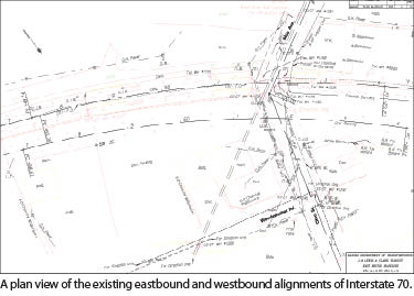
The Lewis and Clark Viaduct consists of nine bridges on Interstate Highway 70 over the Kansas River connecting Kansas City, Kansas and Kansas City, Missouri. A concept was developed in 2011 to replace or rehabilitate the viaduct bridges. The study team reviewed traffic needs, crash information, land-use plans, and roadway and bridge alignments to enhance safety, mobility, and efficiency within the interchange area. The study also incorporated several community engagement opportunities including an online survey, public open houses, and listening sessions. The proposed concept includes a general phasing recommendation based on bridge condition, constructability, and minimal impacts to the traveling public. 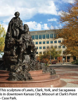 The Kansas Department of Transportation (KDOT) moved forward with preliminary engineering for the first phase of the concept, which includes replacement of the westbound bridge from the Kansas state line to just west of the Kansas River. Although not currently funded, construction is anticipated to begin in the fall of 2016.
Viaduct History
Construction of the eastbound bridge, known as the Intercity Viaduct, was completed in 1907 and originally carried pedestrians, toll traffic, and streetcars. In 1930, a lower deck was added to carry two lanes of automobile traffic. The current westbound bridge was constructed in 1962 north of the older bridge and was named the Lewis and Clark Viaduct. Both bridges officially became the Lewis and Clark Viaduct in 1969. In 2000, the lower level was rehabilitated for pedestrian and bicycle access.
Based on the cost to continue maintaining the existing westbound bridges, the Phase I project will replace Units 1 through 7 of Bridge 030 carrying westbound I-70 starting near the Kansas and Missouri state line to just west of the Kansas River, and it will replace Unit 3 of Bridge 173 carrying westbound I-70 to northbound Fairfax Trafficway.
Burns and McDonnell Engineering Co., Inc., an engineering consulting firm, was selected by KDOT to provide preliminary engineering services for the replacement of the westbound viaduct and river bridge. As a Burns and McDonnell team partner, Wilson & Company was awarded the task of completing the surveying and mapping for design of the project. Wilson & Company was chosen as a team member because of its 80-year commitment of providing engineering and surveying services in the area and its relationship with KDOT.
Planning
 The project started with a collaborative scoping meeting at KDOT headquarters with representatives from Burns and McDonnell, Wilson & Company, and KDOT. This participation from all entities contributed to project success. Bill Haverkamp, PLS, KDOT survey coordinator, and other KDOT staff shared their knowledge on the field survey and mapping deliverables. Wilson & Company’s Jack Butler, PLS, survey project manager, and Mike Lindquist, PLS, chief surveyor, toured the site to become familiar with it and gain first-hand information. They took photos and notes to prepare a high-quality, detailed scope of services and a fee estimate.
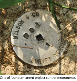
Project planning and coordination are critical for any successful project, and this was no exception. Wilson & Company’s first task was to set four primary control points and 22 secondary points, perform a static GPS network, and site calibration. Secondary control points were needed at selected locations throughout the project. With the project near the Kansas-Missouri state line, checks were made to the Missouri Virtual Reference Station. Ties were made to the secondary airport control (SAC) monuments on the Charles B. Wheeler Downtown Airport. The southwestern extension of Runway 3–21 crosses over I-70, and the team needed to coordinate with airport staff to access the SAC and profile the runway so new design would not penetrate airspace within the approach to the runway. 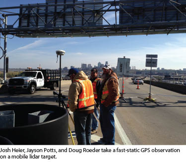 Wilson & Company received authorization from KDOT and Burns and McDonnell to complete the mapping of eastbound and westbound Interstate 70 driving lanes, a portion of the Fairfax Trafficway ramps, a portion of the Minnesota Avenue ramps, and the existing North James Street Bridge over the Kansas River using mobile lidar. Clay Wygant, scanning services manager at WHPacific, another team member, provided mobile lidar data collection using Optech’s Lynx Mobile Mapper V200 system.
Field Surveying
The project was especially challenging and required disciplined focus to field crew safety on one of the busiest roadways in Kansas City. One survey crew was responsible for drilling small holes in the concrete roadway and driving a rivet in the hole at each of the 35 target locations for the mobile lidar, painting a target at each, and setting benchmarks on the structure at 500-foot intervals per KDOT standards. A second survey crew ran differential levels across the viaduct, turning through each benchmark and mobile lidar target. A third survey crew collected horizontal ties to the mapping targets using fast-static GPS observations. Finally, a one-person crew using a Trimble S-6 robotic total station and a TSC3 data collector collected hundreds of ground truthing check shots along the top deck of the structure to verify against the mobile lidar data. This assisted our mappers in creating a triangulated irregular network, while checking the mapping targets to provide redundancy in the GPS measurements.
It was not possible or feasible to close the viaduct to traffic. We contacted Gun-Ko Traffic Control, Inc., to prepare KDOT-approved traffic control plans. After much collaboration and discussion with KDOT, it was decided to close two of the three westbound lanes to provide room for field staff to complete their work with a safety buffer. Upon completion of the westbound portions, Gun-Ko crews would move their cones, barrels, and signs to close the two eastbound lanes. Local television newscasts included short segments to notify the public that survey activities would occur.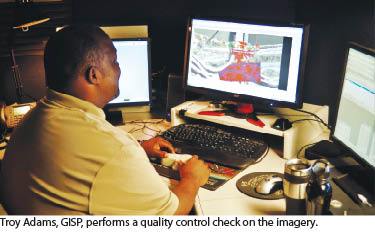 The field survey efforts of the I-70 viaduct were completed in early November 2012 on a Saturday and Sunday to avoid normal workday traffic. The team selected a weekend when both the Kansas City Chiefs and the Sporting Kansas City soccer team were out of town to eliminate game day traffic.
Wilson & Company’s Brandon Espinosa, PLS, survey manager, and Dave Newton, PLS, crew chief, led the efforts for the weekend work that began at 7:00 a.m. Saturday morning. Gun-Ko staff arrived on site at 5:00 a.m. and traffic control was in place when the survey crews arrived. The work began after a site safety meeting with Wilson & Company and Gun-Ko staff. Once the field staff became acclimated to the site and felt comfortable working 30 feet to 100 feet above the land and water below, the survey team completed this portion of the project within the weekend timeframe.
Mobile Scanning
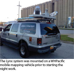 The next task was to collect the mobile lidar data. WHPacific arrived in Kansas City the following Wednesday. Gun-Ko provided an attenuator vehicle and operator and arranged to meet with WHPacific at 8:00 p.m. near the site. The mobile mapper collects data day or night, so the night start time enabled the crew to drive the roadways with minimal traffic impacts. The attenuator truck follow-ed a safe distance behind the mobile mapper to alert any upcoming motorists to slow down and merge. The weather cooperated and the mobile mapping was completed at 11:00 p.m. Multiple passes were driven for redundancy and to ensure complete coverage with overlapping data. Point cloud post-processing was completed using TerraScan, TerraMatch, BlueMarble Geographics, and Virtual Geomatics software with point cloud viewing using Applied Imagery Quick Terrain Modeler and Leica Cyclone software.
To determine the existing alignment of westbound and eastbound I-70, we needed to locate the centers of each existing pier and column. There are more than 200 circular concrete columns or bridge piers and square, lattice, steel support columns. Locating these conventionally would have required multiple instrument set-ups for each column and would have taken an enormous amount of time. Our solution was to use the Riegl VZ 400 scanner.
Wilson & Company’s Jason Taylor led the scanning tasks. After establishing approximately 80 scan control and using more than 200 scanning targets, scanning the entire area underneath the viaduct was completed in less than five days. By scanning the structure, we provided the design engineers with a wealth of detailed information on the underneath portions of the existing structure. 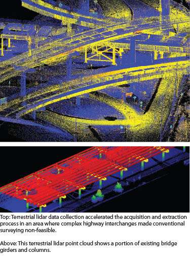 Jason Taylor and Whitney Lynn, geospatial analyst, completed registration of the scans using RiSCAN software, and point cloud data was extracted using TopoDOT software. Determining the column centers from the scan data was completed in a matter of hours and was in agreement with the existing original design plan dimensions to within a few hundredths of a foot. This would have taken several days to compute the locations using conventional survey methods and calculating the column centers in a standard CAD platform. The scan data was also used to supplement the aerial photography in areas impacted by shadows or dense brush, such as areas along the banks of the Kansas River or in areas directly under the bridge deck. Conventional survey data was collected using either Trimble RTK GPS or Trimble S-6 robotic total station with TSC-3 data collectors, or a combination of the two for these areas.
Aerial Imaging
Aerial imagery was collected in a direct digital format using Wilson & Company’s Zeiss/Intergraph digital mapping camera mounted in our Rockwell Commander twin-turbine aircraft piloted by Dan Morrison. The area of mapping encompassed 150 feet each side of existing westbound I-70. The digital photography encompassed approximately 720 acres and extended outside of the mapping limits to provide engineers with photography for use in planning. Aerial targets were placed prior to the flight with additional ground truthing check shots collected prior to the start of mapping.
Hydrography
The Burns and McDonnell design team needed to know the location of scour mats that were placed around the bridge piers in the Kansas River in the 1950s. Their exact location was unknown, but we did know that they are approximately 100 feet upstream and 100 feet downstream of the existing bridge piers and 60-feet wide. The water depth at the piers is approximately 20 feet during normal flow periods, and water clarity is constantly muddy or murky with little to no visibility. The amount of silt covering the scour mats was also unknown.
Wilson & Company devised another creative solution. We contracted with Mainstream Commercial Divers, based in Murray, Kentucky, to locate the corners of the scour mats and suspend a small buoy on the water surface from each corner. Wilson & Company survey staff used a Trimble S-6 robotic total station with reflectorless technology to locate these buoys by angle and distance from existing project control. The scour mats were shown in the mapping deliverable.
A bathymetric survey was completed on a section of the Kansas River beginning near its mouth and extending approximately 2,000 feet upstream. Wilson & Company survey staff performed the hydrographic survey using our 16-foot aluminum watercraft equipped with a SonarMite single beam echo sounder and HYPACK hydrographic survey software. Additional cross sections were run perpendicular to the river channel at pre-determined locations for hydraulic studies.
Rails
BNSF and UPRR share railroad tracks that parallel the west side of the Kansas River with a spur track that diagonally crosses the Kansas River from the west to the east side and runs underneath the existing viaduct as it heads easterly into Missouri. Wilson & Company surveyors coordinated with the railroads to secure a rail escort for field crews to obtain rail horizontal alignments and vertical profiles along approximately one mile of the existing tracks. The design team needed to ensure that minimum clearances over the rails were maintained.
ROW and Boundaries
 The project area is referred to locally as the West Bottoms and is primarily industrial. Most of the properties within the limits of the project are lots and blocks in existing subdivisions, platted in the late 1800s or early 1900s. Individual deeds, existing subdivision plats, and subsequent surveys were obtained during the survey research efforts. Street and road rights-of-way and exterior block boundaries were resolved as part of the final deliverable to the client. The entire field survey, mapping, and deliverables were completed to KDOT survey standards and specifications.
This was a complex and comprehensive project for Wilson & Company sur-veyors and mappers. We incorporated data obtained from many tools including:
- conventional surveying
- static and RTK GPS
- aerial digital orthophotography
- terrestrial scanning
- bathymetric survey
- mobile mapping
Wilson & Company’s CAD manager, John Sloane, combined the data collected from each of these tools into a single basemap deliverable for our client. The project was completed ahead of schedule and on budget.
Meriwether Lewis and William Clark, two of our country’s most memorable and notable surveyors, would be impressed with the mapping created from this arsenal of surveying and mapping tools.