December 2018 Archives
The Three Es
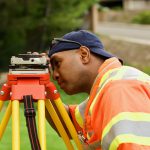
Above: Santiago Canyon College student Scott Givens learns land surveying with the school’s industry-leading technology. Educate, equip, and empower our apprentices Recently I accepted the position of program facilitator for the Surveying and Mapping Department at Santiago Canyon College (SCC), Orange County, California. At SCC we lead by three simple words. First we educate, then […]
Above the Mud
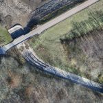
An orthographic image of the exposed spillway at Geode State Park in Iowa at 1″ ground sample distance. To improve water quality in a 500-acre state park, drones are key for surveying drained lakes and the surrounding watershed. Improving water quality is a key part of the Iowa Department of Natural Resources’ (DNR) mission. Planning […]
Who Does SUE?
Subsurface utility engineering lies at the intersection of surveying and engineering. Over the years I have had many discussions with folks in the broader engineering and survey world about subsurface utility engineering (SUE) regarding both the practice and the terminology. One of the main discussions has been whether the practice aligns more closely with engineering […]
Tracking Wildlife from the Sky

Above: Alan Wilson studied how cheetahs hunt with his modified aircraft. Credit: Stuart Dunn. To uncover the source of the cheetahs’ legendary hunting prowess, a researcher used a customized aerial camera to survey, film, and track their hunts. As recently profiled in a BBC documentary, Professor Alan Wilson, head of a research department at the […]
3D Cities from a Single System
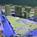
Above: This screenshot is of CityMapper output. A look at the hybrid airborne system that combines lidar with oblique and nadir imagery. Over the last five years I’ve built and used a lot of 3D GIS and BIM models. Almost all of this has required the capture of stereo imagery and oblique imagery and a […]