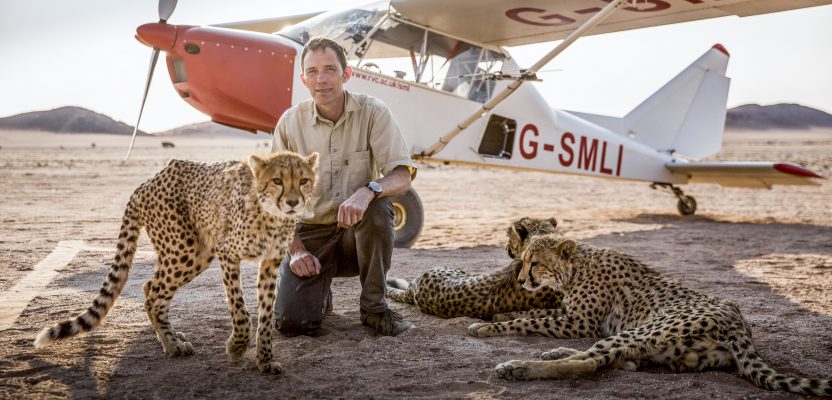
Above: Alan Wilson studied how cheetahs hunt with his modified aircraft. Credit: Stuart Dunn.
To uncover the source of the cheetahs’ legendary hunting prowess, a researcher used a customized aerial camera to survey, film, and track their hunts.
As recently profiled in a BBC documentary, Professor Alan Wilson, head of a research department at the Royal Veterinary College, University of London, and his team have undertaken a study of cheetahs and their prey in the vast savannas of Botswana, in southern Africa.
The team challenged a long-held assumption that speed alone was the cheetah’s key to hunting. Wilson and his team demonstrated that it is actually the cheetah’s agility—the ability to slow down, weave, and change direction—that makes them such powerful hunters.
The GPS tracking collars used in this project provided the animals’ routes and locomotion data. Wilson customized an airplane equipped with a special aerial-imaging camera and related technology to capture the action from the air.
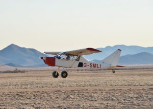
The research aircraft was modified for survey work and wildlife tracking.
Data-collection Equipment
The broader goal of the study was to visualize how animals interact with their terrain. It was the first-ever attempt at such a detailed investigation of animals’ locomotion and ability to cover their terrain without disturbing their habitat or their natural behavior.
Given the vast scale and varied terrain of the study landscape along with the need to minimize contact with the animals, the team decided that aerial data collection would be the ideal and safest solution.
Imaging from a UAV platform was rejected because this approach has been shown to cause disturbance to wildlife while offering insufficient payload and range to cover such large survey areas. Also, there could be regulatory issues with operating UAVs in national reserve areas.
Another option for this project, satellite imaging, would have provided insufficient resolution and at very high cost. Given the remote location of this project, a solution was needed for aerial data collection, photography, and survey that:
- would not disturb either the animals or their habitat;
- could be operated by a single pilot and maintain low operating costs;
- would be versatile, with modular data-collection technology; and
- would be easy to transport and operate in a low-infrastructure environment.
Creating the Trail ADAP
Wilson and his team customized a Groppo Trail lightweight aircraft to operate as an aerial data acquisition platform (ADAP), with the hope of revealing new insights into how animals move, range, hunt, or evade capture and interact with the natural environment.
High-resolution photogrammetry was carried out in conjunction with a Riegl lidar system to create detailed 3D images of the ground, showing vegetation height and density, areas of water, animal tracks, and terrain features such as dips and hollows, termite mounds, mud flats, and features such as fences.
These detailed, high-res photographic images would enable the research team to determine preferred hunting and ranging habitat: information useful also for conservation and land-management planning.
The individual study animals were fitted with movement-tracking collars containing a u-blox GPS and an IMU (inertial measurement unit) consisting of a 3D accelerometer, 3D gyro, and 3D magnetometer. This equipment enabled Wilson’s team to map and analyze the routes, maneuvers, and speeds of hunts as well as how the predator or prey may have used land features to its advantage.
Aerial Camera
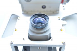
Phase One Industrial’s aerial camera is mounted in its aluminum frame, which fits the camera into a viewing panel in the floor of the aircraft.
This project demanded a high-quality and reliable high-resolution aerial survey camera, so the team chose a Phase One Industrial 80-megapixel, medium-format survey camera. Phase One Industrial worked closely with Wilson to create a bespoke solution for the project, integrating the imaging gear with the on-board lidar and aircraft systems.
The aircraft was modified by installing viewing panels in the floor, designing a waterjet cut aluminum frame mounted in the rear (passenger) location. The camera was integrated with the aircraft’s Novatel dual-frequency GPS/INS system, operating with a Honeywell IMU, enabling each photograph to be stamped with precise aircraft position, altitude, and roll/pitch/yaw.
The camera could be controlled from the aircraft’s custom computer system, allowing single-pilot start/stop and monitoring of the system, either with the Riegl lidar or under independent control by Wilson’s own custom software for photo-only surveys.
System reliability was critically important, as once the aircraft—with its integrated data-collection technology suite—was deployed in a remote area of Botswana, maintenance or repair would become extremely difficult.
The Survey Results
The study required 22 hours of survey flights over hunt routes of 650 sq. km (~250 sq. miles), which generated more than 7,200 photographic images and 600GB of data.
Once the study was completed, the research team used Pix4D photogrammetry software to process the images into a 3D point cloud describing the positions of tracks and obstacles on the routes predators chased prey.
Using the Quick Terrain Modeler software package, they merged that point cloud with the point cloud from the lidar scan to produce highly accurate 3D terrain maps showing tracks, shade-giving vegetation, landscape features, and watering points.
Wilson said, “The […] high-resolution photos produced spectacular aerial imagery and integrated easily with our lidar scans. The camera’s very large high-resolution sensor meant that the resulting images provided not only high resolution to pick out fine detail in the landscape, but also substantial dynamic range to differentiate subtle landscape features by color and tone, even in this arid environment. These results produced the detailed terrain and track visualizations that the research team found essential for this project.”
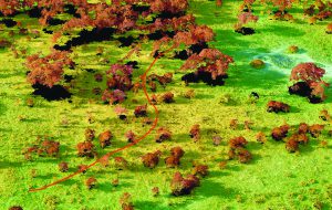
A cheetah track from GPS-collar data is overlaid on height- (blue to green to brown) classified lidar/photogrammetric aerial survey from 1200 feet AGL. Brown trees provide shelter, there’s a dry water hole, and game trails are to the right of the image. (Note that this is at reduced resolution.)
In contrast with consumer 35mm DSLR cameras, the Phase One Industrial camera offered significant benefits, including the quality and resolution of the images, the ease of synchronizing with the GPS and lidar, and the forward motion compensation to remove motion blur at the relatively low heights at which the surveys were flown.
When photographing from a moving viewpoint (such as an airplane), having a camera with a leaf shutter rather than a rolling shutter is an important feature as it exposes the entire chip at the same instant. This prevents the image from blurring and provides the true, sharp image needed for the project. Despite shooting from a height of 1,100 feet, the final images provided sufficiently high-quality resolution at 34mm GSD for scientific analysis of the terrain.
This work was funded by the European Research Council and the UK Biotechnology and Biological Sciences Research Council.