
Street-level imagery and GIS technologies are turning Philadelphia into one smart city
Major metropolises are racing to get ahead of technology that could bring driverless cars and delivery drones to their streets and skies. In Philadelphia, investments in new software and services are already paying dividends in other ways for many of its 1.6 million residents and more than 20,000 city workers spread across 40 agencies.
Every year since 2017, city employees in partnership with experts from Cyclomedia Technology have mapped about 2,800 miles of Philadelphia streets. They captured 360-degree views every 15 feet at street level of high-resolution imagery using light detection and ranging (lidar) technology. Those images paired with the city’s geographic information system (GIS) have been at the foundation of a digital transformation for multiple departments. The technology empowers city staff to save time and increase accuracy by accessing all collected imagery on a single portal from their desktops and devices.
“We don’t stay stagnant. We constantly look at how we can better manage and upgrade our data and tools as well as make the interface more intuitive and easier to use for our employees and our [residents],” said Brian Ivey, GIS manager in the City of Philadelphia’s Office of Innovation and Technology (OIT). “We try to make all the information, particularly geospatial information, make sense, because, at some point, someone is going to make a decision using this information.”
Digitizing Citywide Work for Smarter Results
It’s all part of SmartCityPHL, Philadelphia’s smart city program, which aims to build a more sustainable, economically resilient, and equitable city for the future. The program’s road map includes deploying automated technology to manage energy consumption at municipal buildings by observing operations in real time and adding indoor air-quality sensors. It also introduces voice-powered platforms that allow multilingual residents to interact with city departments more easily.
The citywide initiative of integrating imagery and GIS technologies has been helmed by the CityGeo team at Philadelphia’s OIT.
“Our goal, as a local government, is to utilize every tool at our disposal to innovate and advance government services,” said Ivey.
The first image capture included local universities, Philadelphia International Airport, and the U.S. Navy Yard—all sites for which the city had received repeated external data requests. Now, more than 30 city departments are using GIS and street-level imagery in various ways to do their work.
The top users include the Office of Property Assessment, Department of Records, Public Safety, the Department of Licenses and Inspections, OIT, the Philadelphia Water Department, and the Philadelphia Streets Department.
For example, the Parks and Recreation department, which had before relied heavily on in-person site visits and paper-based operations, applied imagery and GIS to create a tree inventory system for tracking tree species and diseases as well as tree canopy management, saving staff time.
Public Safety accesses the database daily in its work and for long-term planning, such as citywide events, risk mitigation, and Next Generation 911. Calls to 911 now integrate geocoded address points for a more accurate response.
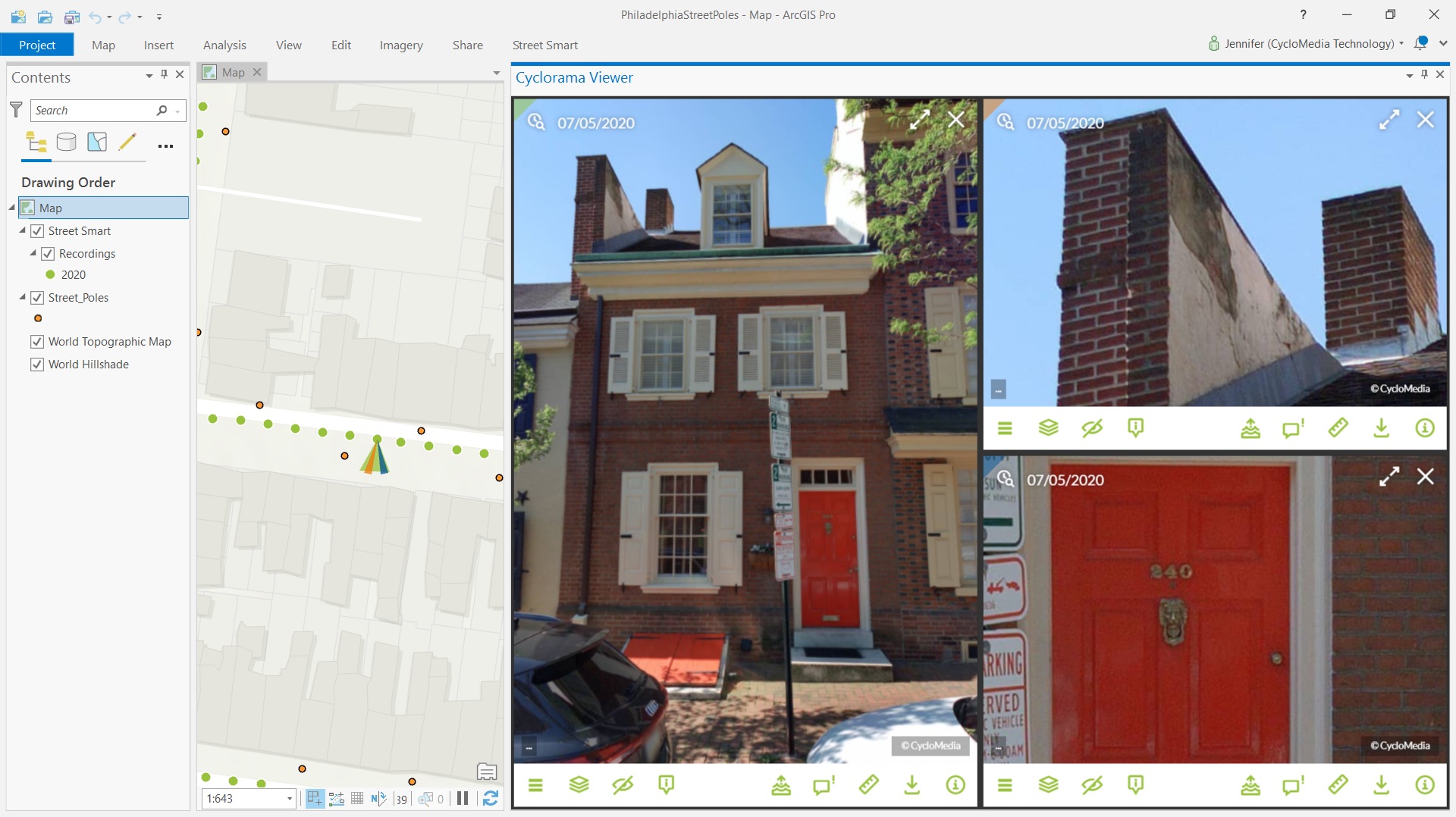
Philadelphia uses Cyclomedia and ArcGIS technologies to remotely assess, verify, and address the conditions of properties across the city.
Central Database Empowers City Staff
The collected imagery and data then find a home in the DataBridge portal, the city’s central data warehouse, where every department sees the same shared information, reducing the potential for duplication or outdated figures. That same information is also shared with the public.
Philadelphia now invests $2.8 million in software and services annually. The city’s digital transformation has roots in the OPA. In the past, city assessors, evaluators, and inspectors from the OPA collected property information through in-person site visits and paper documentation. The process was time-consuming, resulted in data inconsistencies, and led to fewer properties being worked on per day. In some cases, open-source street-level maps were referenced but couldn’t be relied on for accuracy.
To empower OPA staff with accurate information and the ability to accomplish more, Ivey and the team needed a technological solution. They sought a cloud-based service that could provide high-resolution street-level imagery, up-to-date information, and automated workflows. These changes would enable staff to assess more homes and save time spent on in-person trips. Realizing how this solution could aid other departments in meeting business needs across the city, Ivey and his colleagues pivoted to an enterprise-wide option, partnering with Cyclomedia Technology.
“People are still struggling to find ways to get more work done and be more efficient,” said Jason Sealy, a sales executive at Cyclomedia Technology, who worked with the city on its solution. Sealy added that this cloud-based imagery lets users, “see the outside world, your jurisdiction, from the comfort of your desktop.”
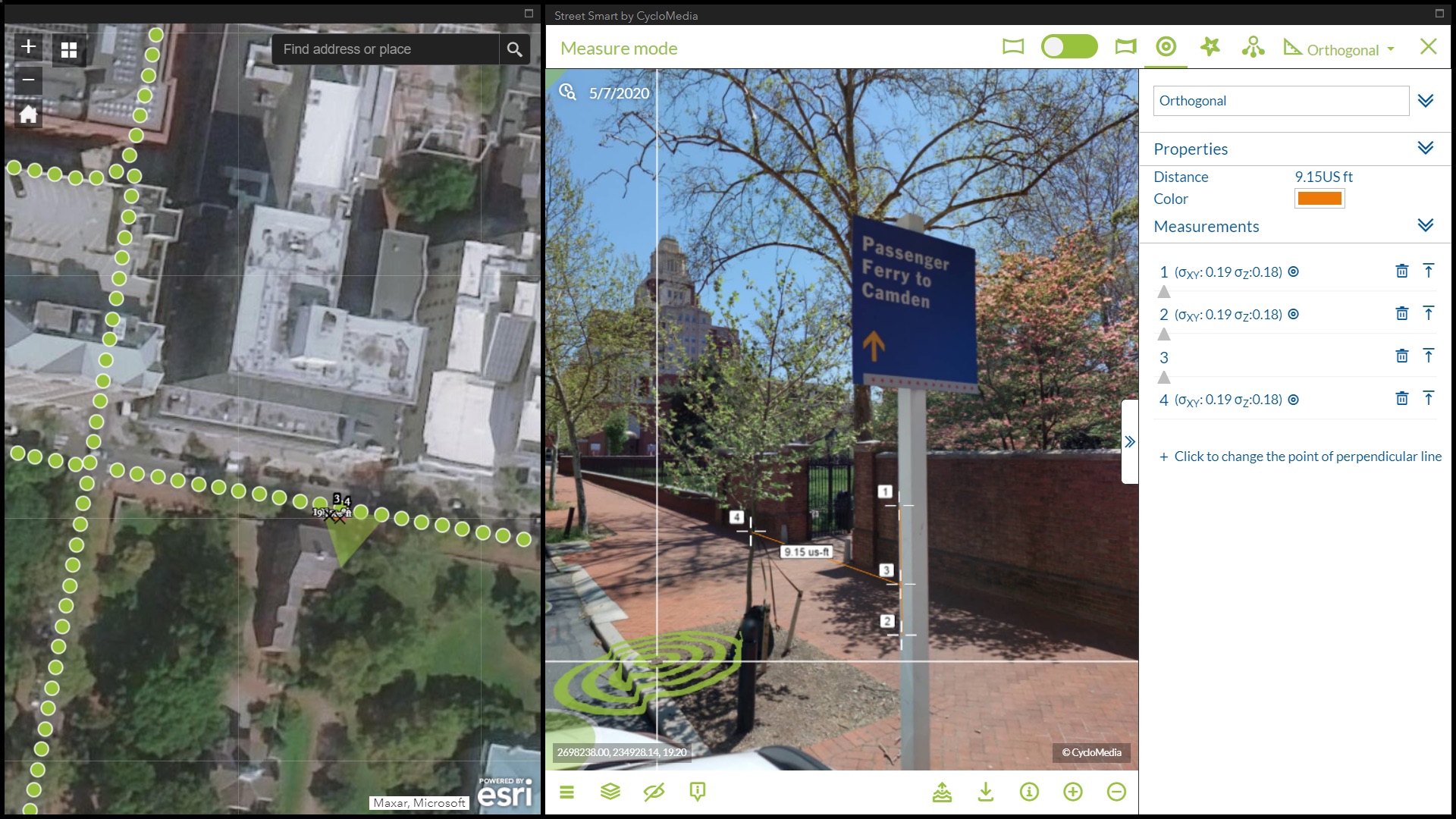
Cyclomedia’s technology provides high-resolution aerial and street-level imagery. When integrated with ArcGIS Web AppBuilder, city staff is able to remotely maintain information about tree location, health, and more.
Providing Universal Visibility to Important Information
After processing, the captured imagery is published and managed through Cyclomedia’s cloud-based system. By integrating imagery with GIS technology from Esri, information can be overlaid with other location-based data to create authoritative, intuitive datasets. All the data and information products are stored in DataBridge.
City of Philadelphia staff tap information from DataBridge and share it publicly through OpenDataPhilly.org as well as the state’s geospatial portal Pennsylvania Spatial Data Access (PASDA). DataBridge serves as the city’s main hub for spatial data as well as many tabular datasets and provides open data for public use.
“We created public-facing mapping websites so that city employees and the public are both looking at the same version of the data,” said Ivey. “With DataBridge, everyone gets the same view of the information.”
Ivey recognized that all departments would want access to imagery and geospatial technology. However, with nearly 21,000 employees, citywide database account management and training would be challenging. To ease the learning curve, they worked with Cyclomedia staff to deploy hands-on training and web-based DataBridge account administration.
In looking to the future and considering SmartCityPHL efforts, Ivey believes that with the right staff and continual monitoring and adapting of new technology systems like GIS and imagery, the opportunities are endless.
“The ability to view and analyze the built environment from one’s desktop with confidence that the imagery is recent and the geospatial data is available and current, gives city workers the tools they need to respond with accuracy and efficiency,” said Ivey.