Key takeaways from a U.S. delegation’s examination of the Swiss cadastre.
Editor’s note: Wisconsin surveyor Rich Leaver recently organized a delegation of U.S. surveyors to Switzerland on the first of what he hopes to be a series of fact-finding visits to countries with formal national cadastral systems. Leaver’s goal is to examine such systems and produce materials and recommendations for potential cadastral system reforms for U.S. states. Here is the delegation’s short summary of key takeaways from the Swiss (SWI) visit.
This summary is in the form of a contrast between the SWI Cadastral system and land records systems as generally instituted in U.S. states and localities. At the core of this initiative is the question: If other countries have evolved their cadastral systems, moving away from legacy, less efficient (and perhaps less equitable) systems, could this not happen in the U.S.?
Kinds of Cadastral Systems
U.S.
The U.S. has homegrown county/city systems, and as many as 3,300 of them. A state like Wisconsin might have as many as 72 different land information systems as it has counties. They may have some core features in common, but in many ways each is unique.
While each system may be a cadastre in the sense that it provides a register of property showing the extent, value, and ownership of land for taxation, there is no “cadastre” in the sense of the national systems that feature authoritative and binding spatial geometries.
There are often no common standards. Often it falls to the strongest personalities from whatever jurisdiction to take the lead and secure funding to further individual causes.
SWI
There is a countrywide cadastree: a hierarchical structure with standards driven from the top, or federal, level. All participants of the cantons, cities, villages and the private sector are under the umbrella of the federal authority.
Everyone who participates is specifically qualified and knows the standards and the rules. There is consistency and uniformity with specific goals to achieve.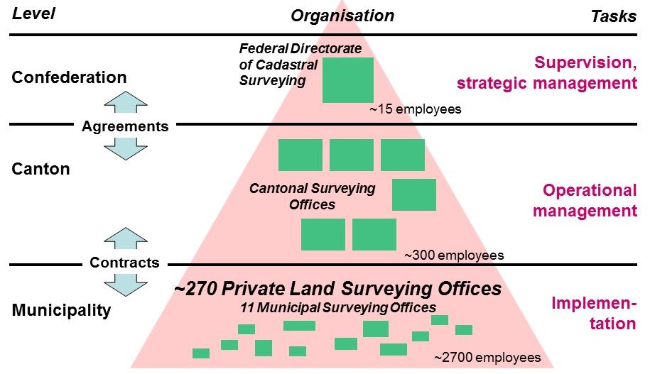
Who Is in Charge
U.S.
In charge are locally elected officials, often with no geospatial knowledge or knowledge of related geo-sciences, technologies, real-property law, geography, or applicable math. Yet, they are [often the first and final line of] decision makers, in each and every one of more than 3,300 different jurisdictions.
SWI
Authority is vested in the federal government, and the federal government has designated a specific agency, Swisstopo [the national mapping agency] in charge of [the cadastral matters] of all cantons. Swisstopo is not comprised of elected politicians, since in SWI, it is necessary to have specifically educated professionals in charge [of such matters]. Putting this into perspective, since SWI is a small country, the scope of jurisdictional authority could be equivalent to one U.S. state.
Land Transaction and Records Focus
U.S.
One transaction, one deed, one survey, one recording: everything is singularly based. While there have been (and are currently) some wider regional and even cursory state-level systems through U.S. history, the systems are fundamentally based on individual transactions.
SWI
Entire areas of any city, village, or equivalent towns are surveyed (or re-surveyed) and mapped comprehensively (i.e. all together). There is no land ownership without parcel registration. And there is no parcel registration without [foundational] land surveying. This policy regarding ownership, parcel registration, and land surveying was adopted in 1912.
Resurveys
U.S.
These are approached one at a time: wherever and whenever the landowner thinks he needs one or is required by the local government (or other entities like title companies) to get a survey. The most-efficient process to modernize old areas with high parcel density (like a comprehensive survey) is not being used. For instance, the percentage of parcels replatted in the last 15 years in Wisconsin may be less than 1%. Replatting is a wonderful process with many advantages, but it’s hardly ever used. [In my opinion,] we could begin to look like SWI if that annual percentage of parcels replatted was somewhere around 10%.
SWI
Vast areas of parcels have been re-surveyed all together, as in a replat. The annual percentage of parcels replatted was somewhere around 10%.
Land Descriptions
U.S.
The lawyers and title companies own this task; the basic element of a land description is the “legal” description. If a surveyor is used, a common practice is to extract the “legal” description from the survey and discard the map or graphic or other important evidence. The U.S. uses the legacy of text in this new digital map world. [In my opinion,] lawyers and title companies do not focus on surveying, cartography, or graphics—and should not. Cadastral surveyors already create authoritative geometries.
SWI
Geospatial professionals own this. “Legal” descriptions [as we are used to seeing in the U.S. system] are not necessary and are [no longer] used. [SWI’s] digital cadastral maps are high accuracy and serve as the basis for describing land.
Parcel Map Disclaimers
U.S.
To get an idea on how the US does this, read the many disclaimers on any county’s parcel mapping. “Cannot be trusted,” “Could be incorrect,” “Accuracy is not verified,” or “You must go back to the recorded source documents or ‘legal’ descriptions.”
If you really want to know where your land is, hire a surveyor, mostly one parcel at a time. Not all county/city systems are viewed as even [accurate or current] enough on which to base all landowners’ assessments and taxes.

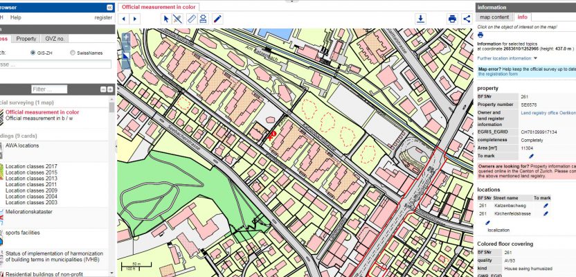
US Parcel Map Disclaimer
SWI
Their parcel mapping system, or cadastre, is trustworthy, reliable, accurate, and authoritative. [Appeals and review/reconciliation of apparent discrepancies occurs through processes and courts, but these are not common.]
Title Insurance
U.S.
[As measured by revenue for the title insurance industry] it is estimated that landowners may have paid as much as $16.4B in title insurance premiums every year. This is to insure title in a system that [in my opinion] is full of gaps, overlaps, and ambiguities.
SWI
The state guarantees title to land. Title insurance is not needed. [There are forms of title insurance, but more of a specialized service and not a standard or mandatory practice].
Education Requirements
U.S.
Sometimes a GIS certificate is required for a job [to work in a local cadastral system] but sometimes it is not. Land surveyors can become licensed any number of ways through education and experience, yet there are licensed professional land surveyors today with no formal related education or training beyond a high-school diploma. [Licensing experience requirements and documentation can be strict, although this varies by state]. The land surveying technician may or may not pursue certification—it is not required.
SWI
All geospatial professionals [who perform work for the cadastre] are highly educated. Cadastral surveyors need the equivalent of a master’s degree, to pass an exam, and to speak two languages. A land surveying technician must have a four-year degree and certification.
Manufacturers’ Systems Used
U.S.
We have access to and utilize all the global technology that is available for our geospatial work.
SWI
[This is more an interesting curiosity than a formal feature of the cadastral system.] Equipment from a manufacturer based in SWI was not used for their countrywide GNSS network. They instead selected gear from a U.S-based company. They have also selected Esri to run [major elements of] their land information systems and use Autodesk products. [If anything, this might indicate that the cadastral system empowers the technical teams to decide which solutions they use].
Private-sector Participation
U.S.
There are government programs with private sector participation and even management by contract. The percentage of public vs. private participation may be hard to determine, because in the U.S. there are so many different systems.
SWI
Overall, there is 90% private-sector participation. The remainder is the government offering oversight and standards’ enforcement. Some cantons elect to do all with government cadastral surveyors (as is the case in Sweden) but most in SWI have high private-sector participation.
GIS/Survey Dynamics
U.S.
There is a legacy strained relationships between these two camps, and while it has improved, some disconnection lingers. Some people in GIS feel it is not necessary to have a formal relationship with the surveying community, and some surveyors argue that GIS means “get it surveyed.” There are more nuances than such generalizations can serve.
Most GIS mapping is based upon the best records available but varies widely from any county/city to another, and hence there is inconsistency—especially representations of parcels. TheThis can be quite problematic as the GIS parcel lines can (and often) are misused, with the end user not knowing how inaccurate the maps might be. This can result in very rough tax assessments, erroneously placed utilities and fences, etc.
SWI
The cadastral surveyor is seen as foundational to any mapping or GIS. There is a vital relationship between the cadastral surveyors and GIS community. Therefore, whatever gets mapped is surveyed accurately within that cadastral system, and the GIS community benefits from this accuracy.
Coordinates and Information for Public Download
U.S.
The general order of calls/evidence in boundary law is natural monuments, artificial monuments, (such as roads and marked or surveyed lines), adjacent tracts or boundaries, courses or directions, distances, area … The status of coordinates is still in flux. In the U.S. there is a general disdain or mistrust of coordinates as being evidentiary., even though every land surveyor uses coordinates every day as the basis for working computations. Local or randomly assigned coordinate systems add to the difficulty.
While all publicly filed land records are subject, ultimately, to public disclosure, there are few jurisdictions where you can readily download cadastral layers or coordinates. Where you can download them, the accuracy, currency, and fidelity to resolved boundaries would not be of a quality or recommended for reliance in any boundary matter. Remember that such themes are typically only for (or should only be used for) tax assessment and zoning and are not true boundary matters.
SWI
Because of their confidence in a properly designed countrywide system by professionals, they now deem coordinates as the highest form of locational information. Only professionals are in charge of coordinates within a rigorously controlled cadastral system, and only qualified cadastral surveyors evaluate the evidence to determine coordinates on any given monument. Anyone can download them from their cadastral system and find markers with coordinates or their property corners.
Property Line Disputes
U.S.
Property disputes because of resurveys and ambiguities, unless resolved by mutual agreement by all parties, can ultimately be resolved only by the courts—a costly and time-consuming process.
SWI
There are few property line disputes because cadastral surveyors resolve them. Disputes that must go to court arise mostly because of personalities involved and usually not from any ambiguities in boundaries. There are only a handful each year.
Publications/Books on Boundary Control and Legal Principles
U.S.
Many publications and books have been written over the years by U.S. lawyers and land surveyors. These contain mostly learned and experienced expert opinions, yet, while they cite case law, they can be a source of disagreement among surveyors. Ultimately, some matters can be resolved only by the courts, and those decisions can vary from jurisdiction to jurisdiction.
SWI
Such publications and books are not necessary because the cadastral surveyors are trained to either avoid or resolve property line disputes. As stated [by someone we spoke to during the SWI visit], “These U.S. [surveying] books are often never translated to German; for the benefit of Swiss cadastral surveyors they would not be relevant.” Cadastral surveyors use textbooks on general surveying practices, of course, but related practices, such as evaluating legacy records, are codified in standards.
Relationship to Civil Engineering
U.S.
Land surveying is sometimes viewed as a subset of the engineering profession. Education for surveyors can be found in technical school curricula known as civil engineering technology. Some very basic courses are devoted to land surveying, but most are engineering.on how to construct highways, including how to test for the correct composition of concrete. The student graduates with very little understanding of what land surveying really is. Yet this is often considered qualifying education for a future land surveyor.
SWI
The land surveying curriculum is loaded with coursework specifically for cadastral surveyors. Cadastral surveyors are not viewed as a subset technical profession of civil engineering. Cadastral surveying stands alone as a necessary profession, and coursework is entirely separate from any civil engineering curricula. Cadastral surveyors are highly educated as identified in #8 above.
Summary
U.S.
[In my opinion,] U.S. land information systems are in some ways archaic—inaccurate, inefficient, directionless—and can be a financial burden to maintain.
SWI
The SWI land information system [and those of other countries with comprehensive and modernized cadastres] are accurate, current, efficient, cost-effective and with direction, they have fewer ambiguities and disputes over time as they have matured.
Notes
The delegates on this trip include Cristine Gayron (NY), Greg de Bruin (NY), Nick Webb (CA), Jon Webb (CA), Jacek Igor Schrott (MI), Samantha Tanner (OR), and Rich Leaver (WI).

The U.S. Delegation
Brent Jones, surveyor and global manager of land records/cadastre at Esri, has a special relationship with the Swisstopo people whom we also met while in Switzerland.
Several of the developers of real-time GNSS networks (RTN) in the U.S. sought advice from Swisstopo as they were one of the first countries to implement a national RTN.
In the U.S. there has been too much focus on the problems and trying to solve these problems within the old paradigm. We need a new paradigm and a new mindset that boldly identifies the problems and most of all the solutions. Once the solutions are identified, we need to look to an existing model where these problems have already been solved. There is no need to re-invent the wheel; the Swiss [and other] model[s may hold the solutions] to our problems.
All-important Swisstopo websites are available in English: www.swisstopo.admin.ch/ The Swisstopo personnel speak one or more of German, French, Italian, or Romansh [as all are official languages of Switzerland] as well as English. In one session, the Swiss presenter had a very good command of English, but when uncertain as to how to say something he would speak to his cadastral surveyor colleague in German for the correct interpretation and then speak it back to us in fluent English. It was fascinating to witness, and the session was very informative.
I have found that one can attend conference after conference for years, even international FIG conferences, and never come away with what one country—SWI—has done, with an understanding of how their system works and how we differ. Therefore the U.S. delegation made a deliberate effort to go and visit, see firsthand, and focus on the very successful SWI model. In this way, we could appreciate all the differences and come away with something tangible and clear.
Recommendations
- Enlist the help of the Swisstopo people in educating the U.S. geospatial community. There is a better way, a far better way, and it is time to identify and seek it.
- State level academic initiatives. For instance, in Wisconsin we could: Begin a cadastral surveyor/geospatial GIS program for at least one state university/college. An engineering program may not be where cadastral belongs; it needs to be under a whole new umbrella, as it is in SWI.
- Begin an online learning program with SWI and award CEUs for the existing U.S. surveying and geospatial community.
- It will take money to convince the lobbyists who will convince our legislators to pass the needed legislation. Unfortunately, this is how our system works. We should assess the total worth of all the geospatial technology industry; show how much benefit there could be to that industry, and perhaps formally seek funding/coordination. It would be appropriate and a good idea to seek the assistance of organization like the National Society of Professional Surveys (NSPS) and the Coalition of Geospatial Organizations (COGO).
- Seek change at any one state level. Focus first on another state where the personnel can get it done. This is where 1/50 odds work in our favor. The goal is to get just one state to adopt the Swiss model. Starting at a national level; our country too large, diverse, and a labyrinth of state and local laws. If we focus on one state, the other states might eventually follow.
- Start funding/partially funding trips to SWI for all U.S. geospatial personnel. Combine this with a vacation package and learning opportunity at Swisstopo.
- Encourage all 50 states to compete and apply for sister-state status with Switzerland. Any state could win this opportunity based upon resources and willingness to change. Switzerland might then help develop a plan for a new model within a state(s), until it is established and fully operational.
- There are other countries with modernized cadastres and have been actively helping other countries, particularly in developing economies, to adopt cadastres and land reform systems. A prime example is Kadaster, the nation land registry and mapping agency of the Netherlands