February 2020 Archives
xyHt magazine February 2020 Edition
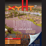
Click on the cover below to view the February 2020 issue of xyHt magazine. Articles in the issue include (links will turn live throughout February): Social Media and the Surveyor Lidar for Floodplain Models: A Project in Florida The Leica BLK2GO: A GRANDSLAM Device How to Get a Drone License
Social Media and the Surveyor (That’s You!)
Why social media is important, and how to participate. One of my favorite parts of the day is opening up LinkedIn and Instagram (IG) where I can admire the lives of surveyors around the world. You work in some of the most beautiful places … and not-so-beautiful places. I get to see how deep the […]
Lidar for Floodplain Models: A Project in Florida
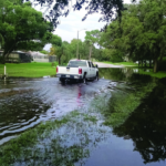
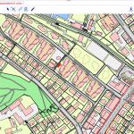
Florida’s topology data gets a needed update with a massive project based on lidar data. Three major hurricanes (Category 4 and above) passed through the Caribbean and the Gulf of Mexico during the 2017 hurricane season—Harvey, Maria, and Irma—and they were three of the five costliest hurricanes in the United States’ history. Hurricane Irma, for […]
The Leica BLK2GO: A GRANDSLAM Device
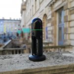
Hexagon Geosystems’ nifty-looking Leica BLK2GO makes geospatial data more accessible to GIS and BIM professionals—as well as to expert surveyors. On a cold, frosty day in December, I’m walking around a skating rink in London with what looks like a device stolen from Doctor Who’s TARDIS. With its sleek exterior and ergonomic design, the Leica […]
Contrasting Cadastral Systems: US Surveyors in Switzerland!
Key takeaways from a U.S. delegation’s examination of the Swiss cadastre. Editor’s note: Wisconsin surveyor Rich Leaver recently organized a delegation of U.S. surveyors to Switzerland on the first of what he hopes to be a series of fact-finding visits to countries with formal national cadastral systems. Leaver’s goal is to examine such systems and […]
How to Get a Drone License

Here is a step-by-step guide to the basics of obtaining an FAA 107 commercial drone license. So—you’re stepping into the aerial arena, taking command of your first unmanned aerial vehicle (drone). Given their usefulness in a wide range of geospatial work, that’s absolutely a smart decision. But you know it’s not as easy as grabbing […]