Understanding datum epochs for accurate measurements and locations in dynamic tectonic areas.
What are datum epochs? Let’s start at the beginning.
“Epoch” is a scientific term used to denote a specific moment or period in time.
Land surveying and geodesy use a numerical “epoch” in decimal years to state the moment at which a given position—in geodetic latitude and longitude or plane coordinates (e.g. northing and easting) and ellipsoid heights—is valid with respect to the geodetic datum.
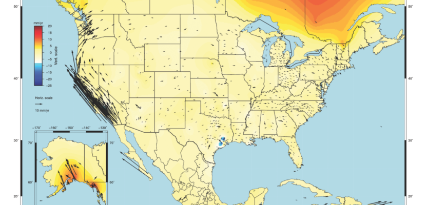
Site velocities with respect to NAD 83(2011) epoch 2010.00. Credit: National Oceanic and Atmospheric Administration (NOAA).
The decimal year is equal to: year + day-in-year/365 (366 for leap years). For example, January 1, 2010 is written as 2010.00; May 5, 1991 is the 128th day and written as 1991.35.
The geodetic datum is a specific mathematical shape and orientation of the Earth, of which there are many; though for this discussion we are mostly interested in the North American Datum of 1983 (NAD83), currently the most common geodetic datum for surveying and mapping in the U.S.
By itself, without the defining “epoch” date tag, “NAD83” alone is at best an incomplete statement, lacking critical information to be useful.
Where Epochs Are Important
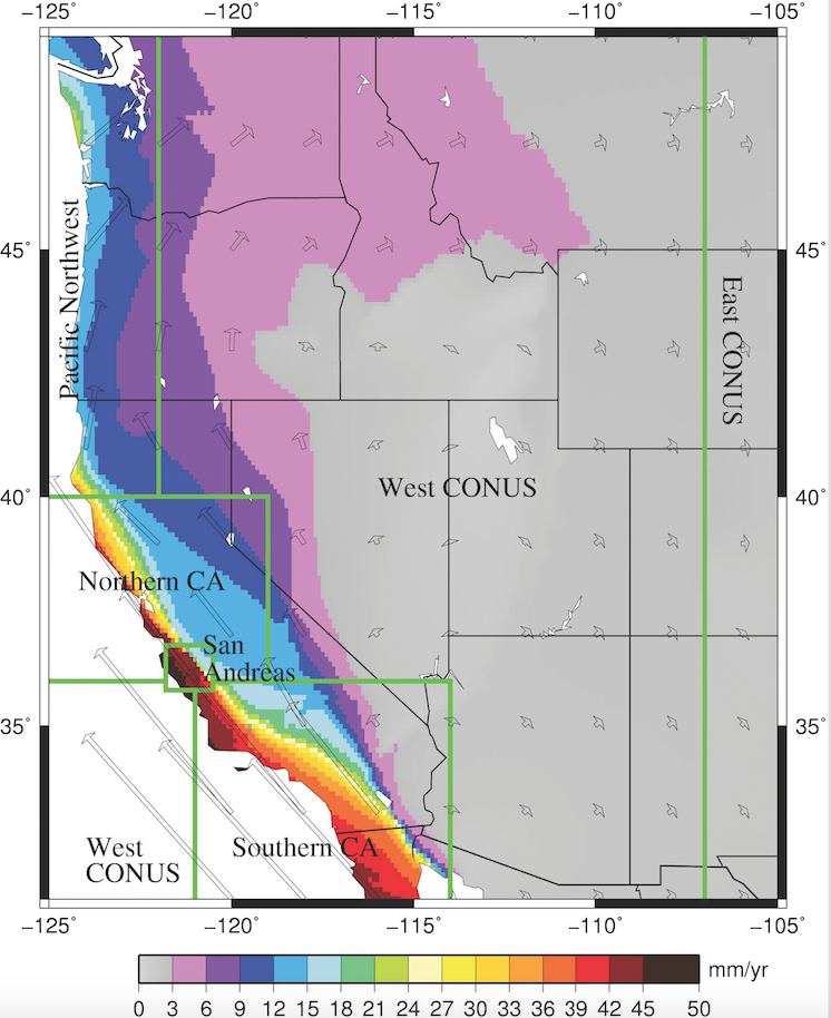
Knowing and applying the epoch of a position (measured or given) can be very important in states such as California, because the framework to which we make typical measurements (latitude/longitude or northing/easting) is fixed to the North American Tectonic Plate.
When you see the terms “NAD83” (North American Datum of 1983) or “CCS83” (California Coordinate System of 1983), you are referring to a datum that is defined in mathematical terms such that it remains relatively fixed to the North American Plate.
Many parts of California, along with several other westerly states, are on the wide deforming boundary (up to hundreds of kilometers) between the North America Plate and the Pacific Plate or the Cascadia Subduction Zone.
It is said that, “As California goes, so goes the nation.” The San Andreas Fault System and the numerous other fault systems along the west coast are clear indicators this does not hold true as far as the physical land on which we live and stand.
The eastern boundary of the Pacific Plate is moving globally to the northwest at 1.5 inches (4 centimeters) each year, and the North American Plate is heading southeast at about 0.75 inches (2 cm) per year.
From the perspective of the North American Plate, the average rate of northwesterly movement along the San Andreas Fault is between 3-5 cm per year. For simple conceptualization, we can imagine the latitude and longitude arcs, the northing and easting lines, or even a CAD X and Y grid as a clear transparent overlay with grid lines. This grid is essentially and purposefully pinned to various places across the United States, where the entire tectonic plate is assumed to be very stable and keeping its shape as one piece of land.
The result is that the coordinates of a point in Kansas, South Dakota, Texas, or Florida remain the same over time, so long as the point is not subject to a local movement (e.g. landslide). Once surveyed, the point can be relocated by use of reference to other control points in the area or to any points on the North American Plate.
Even though the North American Plate itself is moving on the Earth, the NAD83 arcs, lines and grids move with it. The actual movement is essentially hidden from users of geographic or state plane coordinates while on that tectonic plate.
For those of us in an area that isn’t moving in lockstep with the North American Plate, using a datum such as NAD83 presents an extraordinary challenge. Each day, we move northwesterly (nearly as fast as our fingernails grow), while that transparent grid overlay of NAD83 stays behind fixed to the North American Plate. The coordinates of surveyed points in this area progressively degrade over time, relative to the NAD83 geodetic datum.
It is imperative that the date at which the surveyed coordinates were valid relative to the NAD83 geodetic datum is documented; hence the Epoch Date tag.
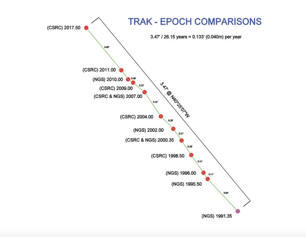
To-scale track of CGPS Station TRAK (Orange County, CA) using published determined coordinates, showing the general northwesterly movement of Southern California. Credit: The Orange County Surveyor’s Office, California.
No-Epoch Dangers
Prior to our ability to easily and precisely locate ourselves with respect to expansive datums such as NAD83, our measurements were locally tied to reference stations, which, if in turn had “old” coordinates, still gave us a way to know where we were relative to what was then the best available information—at least within the reach of our generally available measurement tools.
Today, positional data is abundant, free, spans vast distances, and is provided or requested constantly. Unfortunately, the critical information essential to working as accurately and precisely with respect to a particular epoch date is often not requested, noted, maintained, or provided. This problem is abundant in both the public and private spheres of data collection and publication.
The goal of this discussion is to provide the reader with an understanding of the impact of this oversight and encourage practices that preserve the full benefits of today’s positioning capabilities.
Providing or using a coordinate without knowing the epoch immediately creates an unknown inaccuracy that may not truly exist. Even if the data is not highly accurate, not knowing or applying the epoch creates an unknown shift.
Note that it is not simply “survey points” that suffer from this bad practice; aerial imagery, alignments, linework, terrain models—anything with geospatial values can be incorrectly matched with other data if the specific epochs aren’t accounted for. A good example is the GIS map that shows property lines shifted from fences or buildings. It’s a good bet that the datums of the varying data sets were not aligned.
GPS Adjustments
NAD83 was developed prior to the widespread integration of GPS. Ostensibly, the epoch of the original NAD83 is 1986. The inaccuracies of this initial realization of the datum were great enough that the implementation of GPS soon required readjustments where coordinate values changed up to a meter and resulted in new realizations with the designation of the “High-Precision Geodetic Network” (HPGN) or a “High-Accuracy Reference Network” (HARN). The epoch dates of HPGN/HARN realizations varied by region and state but were commonly on the West Coast in the 1991.35 epoch.
While a few important national readjustments have since occurred since the widespread integration of GPS (e.g. 2007.00, 2011.00) to accommodate additional data and to improve accuracy, most coordinates in the continental United States have not “moved,” in contrast to what we see on the West Coast. Local states and organizations in dynamically moving areas like California have produced various intermediate updates as need and finances allowed, most of which are listed in the example that appears above.
For a simple example of the effect of tectonic movement, consider a single reference point that has been assigned published values for surveying and geodetic use. TRAK is a GPS reference station established in 1994 in Southern California, maintained currently by Art Andrew of the Orange County Surveyor’s Office.
We will start with the first “accurate” HPGN position in 1991.35 and end at the last currently published position by the California Spatial Reference Center at epoch 2017.50. (This latest epoch realization/adjustment was funded through contract with the California Department of Transportation to the great benefit of all geospatial professionals in California.)
To be clear, the same physical spot on the ground and the ground itself is moving with relation to the various datums, and each coordinate is highly accurate; however, depending on the datum and reference epoch, the coordinates of station TRAK can vary by about 4 feet.
The unanswerable question: if one doesn’t have the epoch, where to put the coordinate on the ground? Or, what does a newly measured coordinate mean in relation to other data? If given the epoch of a coordinate value, the appropriate adjustment can be made to place the coordinate in its correct location relative to the datum.
Another way to visualize it is that for any coordinate, the intended point on the ground is moving northwesterly (in most of California). If I stake a given value for which I do not know the epoch, using the very latest epoch (i.e. today), then I can paint an arrow northwesterly and tell the requestor that the real point they are looking for is either here where I staked it or some distance northwesterly up to 4 feet, depending on how old their coordinate’s epoch is.
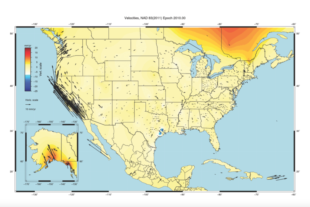
When the epoch dates of prior survey measurements is known, several tools exist to make adjustments between dates using models developed from constant observations of numerous stations across the United States. One such tool, with figures shown here for making clear the disparity of velocity of stations between the East and West Coasts is HTDP. This software allows users to transform positions across time or Horizontal Time-Dependent Position.
Above: Horizontal velocities in western CONUS relative to the NAD_83(2011) realization of the North American Datum of 1983.
Credit: NOAA.
Use Complete Datum Info
The solution to the problem understanding and implementing epoch dates into the practice of those creating and working with geospatial data.
Without fail, the provider of georeferenced information should state the complete datum information, including epoch date, for all positioning data published and used. Without this, there is already a problem that should be resolved before anyone relies upon or accepts the information. Again, “NAD83” itself is not a complete datum statement.
Those who are given any georeferenced information should request that the complete datum statement be included. Again, if this isn’t readily known or available, the value of this data in terms of its accuracy (not precision) is immediately suspect. “State Plane Coordinates” itself is not a complete datum statement.
There are attempts in various specifications and standards to draw out and preserve important measurement information like the epoch date. Unfortunately, this information, if ever provided, is often not preserved along with the points, maps, and information.
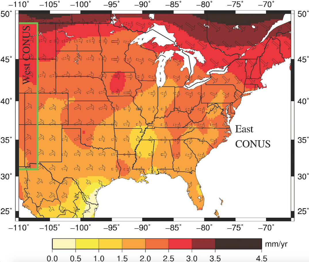
Horizontal velocities in eastern CONUS relative to the NAD_83(2011) realization of the North American Datum of 1983.
Credit: NOAA.
California Coordinate System
As a guideline for explaining the importance of documenting this information, the California Public Resources Code (PRC) §§ 8801-8819 “California Coordinate System” is an excellent resource. In fact, the PRC mandates this practice in various ways. Examples include:
PRC § 8813.3
(a) After December 31, 2005, when a survey that uses or establishes a CCS83 value or values is shown on any document, the station or stations to which the CCS83 value or values are referenced and connected and the CCS83 value or values and the published or stated accuracy or accuracies of that reference station or stations shall be shown also on the document.
PRC § 8815.1
When CCS83 coordinates are shown on any map, corner record, or other document, the map, corner record, or document shall state the epoch (date), in a decimal year format to two decimal places, that is the basis of the coordinate values shown. The epoch shall be shown on the map, corner record, or other document by an appropriate note on the map, corner record, or document or by adding a suffix in parentheses after CCS83 that states the epoch; examples, “CCS83 (1991.35),” “ CCS83 (2002.00),” and so forth.
PRC § 8877
When a CGC83 value or values are shown on any document, the document shall include the following:
(a) A statement that the geodetic coordinate value or values shown are a CGC83 value or values; exceptions shall be noted.
(b) The station or stations to which the CGC83 value or values are referenced and connected and the geodetic coordinate value or values and the published or stated accuracy or accuracies of said reference station or stations.
(c) The epoch of the CGC83 value or values shown. The epoch shall conform to provisions of subdivision (b) of Section 8876.
In the case of the California Public Resources Code, it should be noted that these laws are not solely applicable to the licensed professional (e.g. Land Surveyor).
I prepared this explanation to organize the information, concepts, and advice I repeat too often. My intent is to share these thoughts with those to whom I give and receive data from. Please feel free to distribute as it may help you in your work.
Online Resources
• An excellent and technical report on the difficulty of maintaining a fixed geodetic datum in California is discussed in “Investigations into a Dynamic Datum for California” at http://sopac-csrc.ucsd.edu/wp-content/up loads/2019/12/SIOTask4Report_final.pdf
• The last currently published position by the California Spatial Reference Center can be read at the link
• HTDP: http://ngs.noaa.gov/TOOLS/Htdp/Htdp.shtml