Tag Archives: 3D
How to Use the New QGIS 3D
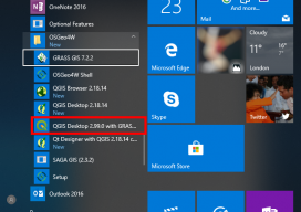
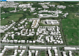
When QGIS revealed that they were going to add a 3D viewer, I was skeptical. Rumors were going around about it being a bolt on functionality and not really being fully adopted. To be perfectly honest, I was put off before there was anything to look at. As screenshots started to appear from Lutra Consulting,...

Weekly xyHt News Links: 10/27/17
Septentrio launches the AsteRx-m2a and AsteRx-m2a UAS at Commercial UAV Expo WiBotic Announces a New Lightweight Onboard Charger Ideal for Wireless Charging of Smaller Drones Teledyne Oceanscience Introduces a new USV! Welcome to Z-Boat 1250! Solve Gas Detection Problems with Microdrones mdTector1000 CH4 Commercial UAV Expo and Drone World Expo Come Together in 2018 OGC...
Making Heightmaps
There is no hiding it: I’ve been building a lot of 3D data recently, partly to sell, partly to fuel my adventures into augmented reality (if you’re interested in me adding this to the blog, please say!). The main vital thing has been the heightmap. Providing Certainty in 3D Heights What is a heightmap, you...
xyHt Weekly News Links: 8/4/17
Dewberry Honored for Special Achievement in GIS Reps. Westerman and Moulton Introduce Bipartisan Geospatial Data Act | Congressman Bruce Westerman GeoCue Announces GNSS Direct Geopositioning System for Low Cost DJI Drones Nearmap Provides High-Rez Oblique Imagery and 3D Products in Ready-to-Use Service ILMF Call for Papers Deadline is August 14! Congressman Doug Lamborn Addresses MAPPS...
xyHt Weekly News Recap: 7/7/17
Tersus launches a ‘new generation’ NeoRTK system senseFly announces worry-free service package to keep professional drone operators flying Surveying the World of Tomorrow CompassCom to Release CompassTracker App for iOS & Windows Mobile Smart Phones at Esri User Conference Trimble Catalyst high-accuracy, on-demand geolocation service now available worldwide Quorum Launches myQuorum Land On Demand, Bringing Speed...

Point A to Point BIM
Our publication is all about how to get from (or measure between) point A to point B: the processes, tools, software, methods, and professional spatial judgments that go into these actions. Sometimes the road between A and B has a lot of twists and turns, and in the case of moving design and construction from...