Tag Archives: 3D

xyHt News Links: 5/20/16
Teledyne Optech and GeoShack sign North American distribution agreement CHC launches high-end GNSS receiver for science, surveying HP Delivers World’s First Production-Ready 3D Printing System COPTRZ™ Launch: Changing The Face Of Construction With Drones Optech Eclipse to be introduced to international audiences at GEO Business UK Esri introduces high-precision GNSS mobile GIS software
xyHt Industry News Links: 4/29/16
Tallysman® Introduces High Performance Triple Band GNSS Antenna + L-Band Trimble Launches End-to-End Field Service Management Suite DJI Introduces Next-Generation Matrice 600 Aerial Platform NovAtel launches 40-centimeter correction service, TerraStar-L The Digit Group and CyberCity 3D Ink Development, Sales and Marketing Agreement Using Streaming 3D Maps for Smart Cities IoT Solutions MIT Develops Control Algorithm...
xyHt News Links: 4/15/16
New Autonomous Airborne Mapping Solution Redefines Industry Expectations Surphaser introduces a new 3D scanner and high precision mobile mapping system SurphSLAM Maptek releases Vulcan 10 and Maptek Workbench MAVinci SIRIUS UAS Surrey Satellite and BridgeSat to Develop Free-Space Satellite Optical Communications Solution Topcon announces global distribution agreement with VMT GmbH Carlson Software Releases Carlson SurvCE...
3D Overnight
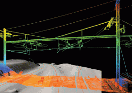
Surveying the Arsenal Interlocking rail corridor in Philadelphia safely and efficiently with mobile lidar. An old section of the Pennsylvania railroad called the Arsenal Interlocking is now one of the busiest segments of rail for the Southeastern Pennsylvania Transit Authority (Septa) regional rail system. A high volume of trains operates in this territory due to the...

Why 3D GIS Is the Future
“The world we live in is a three-dimensional world, so why do we map it and analyse it in just two dimensions?” —Dragons8mycat, 2013 In the last five years, we, the GIS industry, have made some fantastic advances. So, why is it that we are so slow with the adoption of using 3D data? Surveyors...
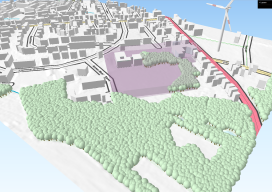
Further Adventures with 3D GIS
Last year I posted about this awesome plugin called “QGIS2Threejs” [here] and how it was possible to quickly render 3D visualisations for free using the open source GIS, QGIS. At the time I fudged some wind turbines as it was impossible to import models. Furthermore, I avoided too much detail as any imagery would look...