Tag Archives: 3D

123D Catch for the Masses
How to Make A 3D Model of Your Sleeping Cat Stereoscopic imaging, better known as 3D, is not new. In the 16th century, “binocular” images were viewed cross-eyed. In 1838, Sir Charles Wheatstone invented the stereoscope to give depth to images. It presented two offset 2D images separately to the left and right eye of...

Wizardly 3D
Above: This hologram of a church in Texas was built from a combination of airborne and terrestrial lidar scans. More than just illusions, hologram technology is booming. Every once in a while a new product or technology comes out that makes you do a double take and think, “Wait, what is that?” This happened to me...
True 3D Design
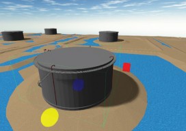
New geospatial software combines the appeal of games with the rigor of applications. It’s never been done before: applying the rigor and disciplines of civil engineering, mining engineering, hydrology, and even classic survey field-to-finish to game-like 3D design. Sure, CAD operators have had 3D viewing for years, which they use to review the results of...
Blending Realities
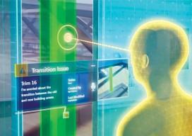
A 3D design and visualization tool with phenomenal potential in the AEC world is coming from a collaboration between Microsoft and Trimble. Imagine designing an object, in 3D and color, using only gaze, gestures, and voice (GGV) commands. Imagine designing an entire building the same way—or modifying an existing one. Imagine moving in a physical...

3D GIS
Breaking the Wall between Consumer and Professional, the Appearance of Disappearance, Versioning An Interview with Lawrie Jordon Contrary to what the current buzz might indicate, GIS and CAD have been 3D-rich from their start (although sometimes with elevation as an attribute, not necessarily part of the core spatial definition). Even in the 1990s era of...
Creating the Futuristic Worlds of 3D
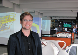
We interviewed Autodesk’s technology futurist Jordan Brandt, appropriately, in the Autodesk Gallery at their One Market offices in San Francisco. The Gallery, open to the public and the venue for monthly techie events, is a showcase for eye-popping examples of the types of innovation Autodesk’s customers have been producing for more than three decades. It...