Tag Archives: gnss
Where Theory Meets Practice: Geodetic Observations – Part 2
Part 1 of this article (March 2014) presents the differences between azimuths that surveyors observe with a total station and the geodetic azimuths listed in GNSS adjustment reports. However, the effect on angles caused by the deflection of the vertical at the observing station is typically small. Thus, the difference between the observed astronomic angle and...
Where Theory Meets Practice: Transformations and Reference Frames, Part 2
In the previous article (PSM Dec. 2013), I mention the practical problems of control being in different reference frames, and I present the surveying solution to this problem. In this article I address how to determine if the localization process was successful. To do this we will need to look at the statistics of the...
Survey Web Tools
How to use them for land survey planning and reconnaissance. When I first used GNSS, it was my usual practice to go to the National Geodetic Survey (NGS) website to gather the data sheets for control monuments in the vicinity of my project area. I would plot these in a program called TopoScout, a topographic...
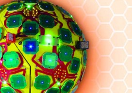
GNSS Antennas that Protect and Observe
Editor’s note: Public awareness of the potential for interference and jamming has rightfully increased over the past few years; due partially to at least one high profile incident each of “trucker jammers,” news of battlefield jamming, the jamming event along the North Korean border, and an inadvertent interference instance of naval origin in San Diego....

Artful GNSS
Things in the nation’s capital can happen quickly, but only when the parties involved agree to work closely together towards a common goal. Internationally renowned artist Jorge Rodriquez-Gerada was given six months to develop a plan and complete a six-acre painting using sand and topsoil. His canvas would be an incredibly high-profile piece of National...
It’s About Time
Australia tech-rebel company Locata is poised to profoundly change the world of positioning, navigation, and timing. In 1994 in Canberra, Australia, accomplished musician and entrepreneur Nunzio Gambale was introduced to a fellow musician, David Small, by Gambale’s cousin who had been giving Small a hand with an interesting experiment. This chance meeting began an amazing partnership in technological development. The scenic capital territory of Australia has its fair...