Tag Archives: gnss
I Don’t Need No Stinkin’ Statistics
Surveying Statistics, Part 1 Do you perform GNSS surveys? Do you use OPUS or perform RTK surveys simply because you don’t understand your software’s output? Do you always use the compass-rule adjustment for traverse data simply because that’s the way you have always done it? Do you ever have a situation where you know something...
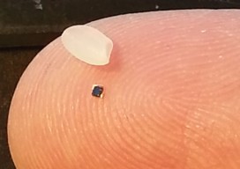
RFID
Above: RFID tags take many forms. The inside of a tag shown above—designed to attach to metal infrastructure in harsh environments, such as water pipes and valves—has a thin copper “bow-tie” antenna with a minuscule chip in the middle. It’s shown contrasted with a grain of rice. An electronic handshake has brought together the worlds...
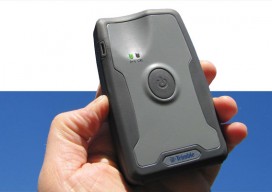
Mapping Peripheral
A review of Trimble’s R1, a GNSS Bluetooth peripheral for mobile devices, with multiple options for correction sources. The idea of a GNSS “puck” has broad appeal: a peripheral GNSS receiver to precision-enable mobile devices such as smart phones, tablets, and a variety of purpose-built field-data-collection devices. There is a lot of functional territory between...
GNSS Next: A Control Center for Real-time GNSS Data
Editor’s Note: GNSS is a global amenity that all segments of society now rely on. While low-precision uses of GNSS can work with the default broadcast products alone, directly from the satellites, all high-precision GNSS uses rely to varying degrees on external “value added” data products. These products, such as enhanced clock and orbit data, are...
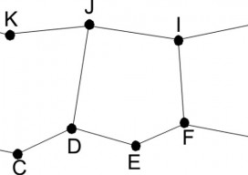
Where Theory Meets Practice: Geodetic Observations: Part 1
Since the inception of GPS in the 1980s, surveyors have been presented with GPS baseline reduction results that list both geodetic azimuths and distances for the baseline vectors. In Part I of this article, I present the difference between the normal to the geoid and ellipsoid, which is known as deflection of the vertical, and...
Where Theory Meets Practice: Geodetic Observations – Part 2
Part 1 of this article (March 2014) presents the differences between azimuths that surveyors observe with a total station and the geodetic azimuths listed in GNSS adjustment reports. However, the effect on angles caused by the deflection of the vertical at the observing station is typically small. Thus, the difference between the observed astronomic angle and...