Tag Archives: surveying

Touching Off a Stampede
Sponsored by Carlson Software In the old days of surveying, it was common practice to fill out a crew with a “warm body”—anyone who could follow directions and hold a rod would suffice. One of those guys who was assigned to my crew was a young man by the name of Chris. Since Chris was...

xyHt Weekly News Recap: 09/16/2022
New Report Assesses Effects of Operating a Terrestrial Radio Network Near GPS Frequency Bands UESI Surveying & Geomatics Conference 2022 Registration for CONEXPO-CON/AGG and IFPE 2023 is Open Airbus, Hiratagakuen to Test Future eVTOL Flight Routes in Kansai Region Hexagon Announces Aerial Data Collection of Eight U.S. States at 6-inch Resolution Susan O’Malley to be...

xyHt Weekly News Recap: 09/23/2022
Diane Dumashie Elected President of FIG Apple Co-Founder Wozniak to Join Trimble CEO on the Keynote Stage at Trimble Dimensions InterGeo 2022 Set for Essen, Germany, Next Month New Trimble TerraFlex Software Edition Simplifies GIS Data Capture Bluesky Takes to the Skies to Capture More Oblique Views of UK Cities The GIS Certification Institute (GISCI) Welcomes...

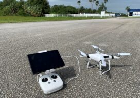
UAS and ALTA Surveys – Part One
Recognizing that with the right equipment and practices, specifications for ALTA surveys can easily be met, surveyors have rapidly adopted UAS for these and many other types of surveys. The adoption of UAS in the surveying profession has been more rapid than some past tech. It was only 2016 when the FAA Part 107...

Legal Boundaries: Where to Put the Excess
This month’s question comes from a reader. “What is the customary solution to discovery of extra block length when all except the end lot status quo ante are equal 50-foot-wide lots and the extra space is within the parking area of the end lot?” In my experience, an excess in the block is rarely challenged....

xyHt Weekly News Recap: 08/26/2022
Public Comment Requested on Revision to OGC 3D Streaming Community Standard Commercial geospatial technologies that detect GPS disruptions to be tested in military exercises Senators Urge FCC to Reconsider Order Granting Ligado Applications Civil GPS Service Interface Committee Meeting Set for September 19-20 EuroGeographics welcomes strengthened UN-GGIM Reveal Technology and Teal Drones Demonstrate Multi-Drone Mapping...
