Tag Archives: surveying

Field Hazards: A Two-Copperhead Tuesday
It’s hot, dang hot here in Georgia. It’s so hot, you wish somebody would hit you in the head with a wet squirrel and cool you off! As a 56-year-old registered surveyor/party chief/instrument man/rodman/cad tech and office cleaner, I’m tired, hot, mosquito bit, chigger infested, and Grand-Central-Station for all of the ticks trying to get...
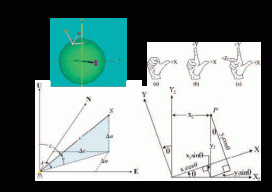
Transformation of Observations
Educate: Where Theory Meets Practice In previous articles I’ve discussed the reduction of conventional surveying observations to their geodetic equivalents. This article presents how these observations can be reduced to simple vector components that match GNSS surveyed baseline vectors. Unfortunately this transformation of conventional observations to GNSS baseline vectors involves three-dimensional rotations, so the mathematics will increase....

Imaging Rover on the Canal
A Florida surveying company puts a new technology to the test on an historic canal fronted by 21 subdivisions. Editor’s note: The announcement of the Trimble V10 imaging rover in late 2013 was greeted with a mix of excitement and questions (“what is it?”). With close-range photogrammetry just beginning to reach the toolboxes of surveyors...
Future of Determining Elevation
A frank discussion of the different heights used in surveying, what’s inside a geoid model, and how geoid model data is used within GNSS software to produce elevations. Certainly most geospatial professionals who have used Global Navigation Satellite Systems (GNSS) within their surveying workflows have come across the term “geoid model” before. But who actually knows...
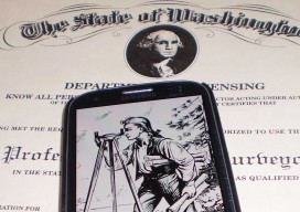
A Post-licensing World for Surveying?
One geospatial professional’s suggestions on increasing the professional aspect and relevancy of the surveying profession. Editor’s note: The subject of licensure for surveyors, photogrammetrists, and other geospatial professionals has heated up of late. This has been as a result of efforts in a number of states, including Tennessee and Washington, to redefine the definition of...
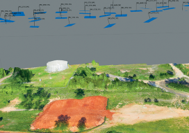
Accuracy With Small UAS Mapping
Two recent advances in heretofore unrelated technologies are giving birth to a new way to perform local-area metric mapping. The first is the development of small, unmanned aerial systems (sUAS), spurred on primarily by the miniaturization of autopilot components. The second is the development of novel algorithms for creating digital surface models from collections of...