Tag Archives: Trimble
Lindsay Renkel
Lindsay Renkel – Geospatial Marketing Specialist, Trimble – Colorado USA In the not-so-recent past, segments of geospatial industries were viewed more as rigid verticals, and cross-discipline and integrated workflows were realized through innovation in applied tech. That’s when companies like Trimble began to organize under new functional divisions. Marketing a broader range of products and services could...

xyHt News Links: 11/13/15
EngineerSupply Ranks in the Top 300 of B2B Maps go 3D thanks to machine vision Lockheed Martin Advances Threat Protection on GPS Control Segment Spirent Issues Ebook on Testing Drones, UAVs Ebook: An Introduction to Testing Navigation and Positioning Performance in Drones, UAS and UAVs. Vricon introduces groundbreaking medium-resolution digital surface model The Geological Society...

Blending Realities
A 3D design and visualization tool with phenomenal potential in the AEC world is coming from a collaboration between Microsoft and Trimble. Imagine designing an object, in 3D and color, using only gaze, gestures, and voice (GGV) commands. Imagine designing an entire building the same way—or modifying an existing one. Imagine moving in a physical...

Multicopter Profiles
The eXom, RiCOPTER, Aibot X6, and Trimble ZX5 SenseFly’s eXom Inspection and close-in mapping sUAS I first saw sensFly’s new eXom sUAS at the ILMF conference in Denver early this year. It’s billed as an inspection and close-in mapping platform, and I thought, “Inspection? That’s interesting” and moved on. Turns out the team at senseFly...
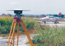
We Are Aviators First
With UAS, surveyors are becoming aviators. As we adopt new technology, we should heed old advice. I flew my first photogrammetric mission in the early 1980s while I was completing my geodesy degree during tumultuous times at my alma mater. While the rest of the world had disco fever, students at Universidad Central de Venezuela...
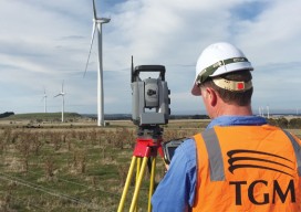
Capturing the Wind
A one-person crew provides foundational data for building a massive wind farm in Australia, using integrated survey technology. When you look at the commanding stature and aesthetically pleasing symmetry of the turbine towers at the Mt Mercer Wind Farm in southeast Australia, it is easy to gloss over the central role that surveying and engineering...