Tag Archives: Trimble
Time to Do More
xyHt has been watching a recent flurry of news releases and webinar announcements from Trimble tagged with the slogan “Time to Do More.” There were quite a few major new products and enhancements announced so we wondered: Was this simply a marketing campaign? Or was this some new direction for Trimble? We decided to ask...
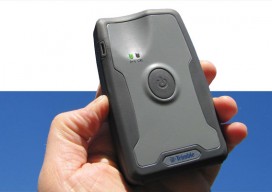
Mapping Peripheral
A review of Trimble’s R1, a GNSS Bluetooth peripheral for mobile devices, with multiple options for correction sources. The idea of a GNSS “puck” has broad appeal: a peripheral GNSS receiver to precision-enable mobile devices such as smart phones, tablets, and a variety of purpose-built field-data-collection devices. There is a lot of functional territory between...
Business Leader: Trimble’s Rob Miller Talks UAS
Unmanned Aircraft Systems (UAS) have hit the mainstream, or at the very least they’re poised to be ready for take-off when the FAA rules for commercial use are ready (possibly in 2015). For an insight from a supporting industry we interviewed Rob Miller, the product portfolio manager for Unmanned Systems at Trimble.PSM: Do you feel that...
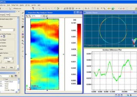
Exceeding the Limits
Forensic survey technology is now a need rather than a luxury as Latin America’s urban concentration accelerates. For decades the art and science of determining how a crime was commit-ted and how a car crash occurred has relied on expert hypotheses based on personal experience and memory. Experts have used tape measures, cameras, and paper...

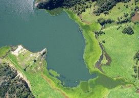
Satellite Signals Steer Farmers Straight
Precision agriculture combines GPS, remote sensing, and GIS to capture large amounts of georeferenced data on spatial variations in soil types, moisture content, nutrient availability, and crop yields and then create and follow prescription maps. Until recently, it was difficult for growers to correlate soil and crop information with production techniques, so they generally treated...
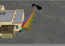
All Over the Map
The regulations and uses of UAVs for mapping in Latin America are as diverse as those cultures, but their drivers are much the same as we see here in the United States. Using manned airplanes for aerial photography and photogrammetry is an especially expensive proposition for countries south of the Rio Grande. The reasons are...