Tag Archives: xyHt
xyHt Magazine Digital Edition: June 2021
xyHt's June issue features hydrography and the need to survey everything water related.
Island Hopping
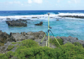
Using topo-bathy lidar to map distant islands helps develop high-resolution 3D topographic data for the U.S. and its territories

xyHt Weekly News Recap: 05/28/2021
Sonardyne Unveils Portable Shallow-water Tracking System OGA Launches GIS Virtual Gallery of Apps First Detailed Images from the Pléiades Neo 3 Satellite USGIF Hosts Second GEOINT Service Day Concept3D Introduces New 360° Map National Geospatial-Intelligence Agency Seeks Enhancements in Predicting Overhead Geopose

Sometimes It’s Just Best to Walk Away
Surveyors are usually a tough bunch and don’t normally retreat from difficulties. When there are thorns, thistles, and briars on line, they usually reach for the machete and carve a path through.
xyHt Weekly News Recap: 05/21/2021
Teledyne Completes Acquisition of FLIR Trimble Introduces VRS Now Correction Services to Norway EOfactory.ai Scales Up Capabilities with CATALYST Microservices Skyward Introduces Mapping and Modeling powered by Pix4D Next GEOINT Service Day Series is June 9 Woolpert, Planet Partner to Deliver Imagery Worldwide Jack Dangermond Honored by IGU with Planet and Humanity Medal Bluesky 5cm...

The Early Days of 3D Laser Scanning: Part 11
In 1998 I joined a small start-up, Cyra Technologies, which was pioneering 3D laser scanning technology. I had a senior product marketing role, reporting to the CEO.