Tag Archives: xyHt

When Mapping Goes Viral
Digital mapping has boomed during the COVID-19 pandemic. From tracking cases to allocating vaccines, GIS technology is at the frontline of the war to beat the virus.

xyHt Weekly News Recap: 06/25/2021
Teledyne Optech makes First Delivery of CZMIL SuperNova Robotic-based Solutions Enhances Curb and Gutter Paving Performance Bentley Acquires 3D Modeling Software Company Seequent Keynote Lineup Announced for Commercial UAV Expo Americas 2021 Trimble and Infotech to Streamline Inspection Workflows for Infrastructure Projects J. Dan Bremser Named President of Massachusetts Surveyors Organization Geo Week has Massive...
xyHt Weekly News Recap: 06/18/2021
Teledyne Launches New Bathymetric Lidar Solution Riegl Airborne Laser Scanner is a Leap Forward New Lidar System Delivers Long-Range Capability Northamptonshire Fire and Rescue Adopts GIS Software for Risk Analysis Robotic-based Solutions Enhance Curb and Gutter Paving Performance Toshiba Looks to Expand Solid-State LiDAR to Infrastructure Monitoring URISA Announces 2021 University Student and Young...

Careful Where You Step
Any surveyor who has spent more than a few days in the field knows insects, reptiles, and other critters that exist in the wild can ruin your day. Yellowjackets and other stinging bees are some of the more common causes of pain for surveyors in the eastern United States, but venomous snakes are the critters we worry most about encountering. I think...
xyHt Weekly News Recap: 06/04/2021
The Earth Archive Virtual Congress – Complimentary Registration ASPRS Announces Government Services Scholarship Pix4D Celebrates 10 Year Anniversary Virtual Surveyor Enhances Stockpile Reporting in Drone Surveying Software CGA’s Fourth Annual Technology Report Details Vision for Ideal 2030 Excavation CATALYST Collaborates with Amazon Web Services to Deliver Geospatial Insights New Mapping Tool Helps Parks Plan for Climate...
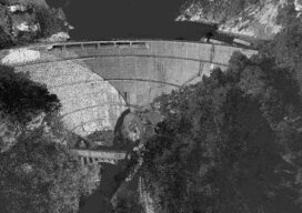
Damming Evidence – Using Lidar Models to Characterize Dam Sites
Dams are some of America’s biggest and potentially most dangerous civil engineering projects, so engineers need highly accurate models of these structures for testing.