Former governor says U.S. spatial data leadership has slipped.
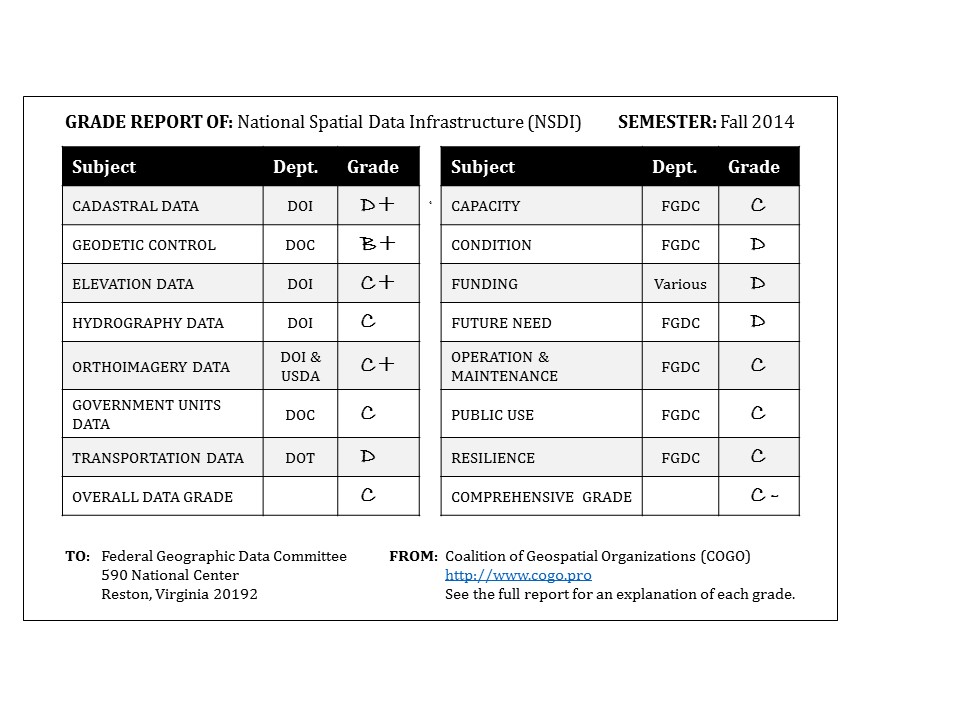
The nation’s spatial data infrastructure gets a barely passing grade of “C” indicating it “requires attention,” former Governor Jim Geringer (R-WY) reported on February 23.
Speaking at a news conference at the National Press Club in Washington, Geringer said the national spatial data infrastructure (NSDI), a series of current maps and geographic information envisioned by an Executive Order issued by President Bill Clinton in 1994, is “not complete and not well governed” and called for a “move into a coordinated and integrated data set.”
Now the director of policy and public sector strategies at GIS software firm Esri, Geringer, who served as Wyoming governor from 1995 to 2003, is chair of an expert panel convened by the Coalition of Geospatial Organizations (COGO) to evaluate the NSDI.
Geringer said the report card on spatial infrastructure, modeled after the American Society of Civil Engineers report card on physical infrastructure, shows there are “no effective metrics” to measure progress on the NSDI.
COGO Report Card
He called for a “shift in data production from the federal government to the private sector” and “new public-private partnerships” to accomplish the NSDI. Numerous government studies have found that government agencies duplicate, in some cases compete with, and fail to adequately utilize private sector surveying and mapping firms.
When asked, particularly as a former governor, how a nation as economically advanced as the United States can be so poorly mapped as to earn a grade of “C,” Geringer said that geospatial data framework data was “my reference” when making policy or doing analysis. “You don’t even know you’re making an erroneous assumption” when using dated, incomplete or inaccurate spatial data. He said that “impacts the quality of a decision.”
Geringer went on to say spatial data affects “decision-making, policy, and economics” and noted that many other countries, perhaps 15 or so, would get a higher report card grade than the United States, and pointed to Abu Dhabi as an example of a nation that has an excellent spatial data infrastructure and uses it in almost every government decision and program.
The Report Card encourages government agencies to improve the national spatial data infrastructure to better support efficient government operations at all levels. Geringer said, “The goal of the Report Card evaluation is to bring attention to the need for current and accurate geospatial data for the nation.”
The news conference was scheduled to coincide with a meeting of the National Governors Association, where Geringer said the states’ chief executives are “dependent on this information to make state governments work in the most efficient, cost-effective way possible.” He went on to say, “Government agencies at every level are dependent on this data, as are private sector businesses. We need state and federal government to make improvement of the NSDI a high priority so the nation can make significant, rapid progress on jobs, education, economic growth, public safety, energy, natural resource management, health care, agriculture, transportation and other areas. This information will also allow us to track and manage our progress in all these areas, reducing duplication and ensuring sustainability of our efforts over time.”
In addition to an overall grade of C, the report card graded NSDI efforts in seven data framework layers. The layers, and their grades are:
- Cadastral D+
- Geodetic Control B+
- Elevation C+
- Hydrography C
- Orthoimagery C+
- Governmental Units C
- Transportation D
In addition to Geringer, the panel included Dr. David Cowen, professor emeritus in geography at the University of South Carolina and a former chair of the National Research Council’s mapping Sciences Committee and former chair of the federal government’s National Geospatial Advisory Committee; John Moeller, former executive director of the Federal Geographic Data Committee; Dr. John Bossler, retired chief of the Coast and Geodetic Survey of the National Oceanic and Atmospheric Administration and former chair of the Center for Mapping at The Ohio State University; Robert Welch, former president of the Wisconsin State Senate and a licensed professional surveyor, Thomas Rust, a professional engineer and member of the Virginia House of Delegates, and Susan Carson Lambert, former executive director of the Kentucky Office of Geographic Information.
COGO is a coalition of the nation’s leading trade associations and professional societies in the geographic information field.