Technology is making geospatial information real-time and relevant.
As powerful, easy-to-use applications and up-to-date location data become available, businesses and consumers are significantly increasing their use of geospatial information. Today’s smartphones and mobile tablets easily access online maps, obtain directions to specific addresses, assess traffic patterns en route, and allow users to plan for the weather all along the way. This kind of information is enabling people to make more intelligent, informed decisions “on-the-fly.” Real-time, accurate geospatial information is changing our lives at home, at work, and on the go.
Real-time intelligence offers enormous opportunities to businesses and organizations especially. Imagine military commanders knowing exactly the location of targets at exact times. Imagine first responders knowing precisely when and where help is needed after an emergency event such as a flood or hurricane. Real-time, accurate geospatial information delivers intelligence to decision makers in many other arenas, improving the way they operate and perform.
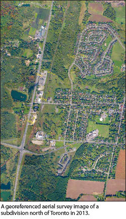
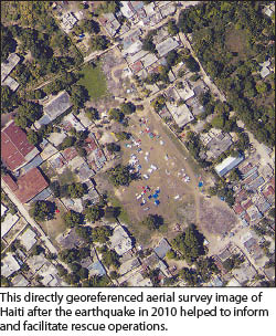 The more current and accurate available data is, the smarter decisions are, and the faster they are made. Accurate, georeferenced orthorectified maps are best created by aerial survey – this method is fast, efficient, and proven. Producing them, however, has historically required considerable time to process and finalize. Until now. Thanks to several technological advancements, “in-flight ortho production” is now not only possible but also commercially available. An example is Trimble’s new DSS 500 with In-FlightOrtho software that is capable of producing georeferenced map products while in the air, prior to landing.
Six specific technological developments have enabled In-FlightOrtho and the resulting intelligence.
Real-time Direct Georeferencing
Georeferencing means defining an object’s existence in physical space, i.e. establishing its location in terms of map projections or coordinate systems. Real-time direct georeferencing means directly measuring an object’s position and orientation relative to the Earth using satellite positioning and inertial measuring units in real-time, without the use of ground control survey points that are costly and time consuming.
The exact location of an object (latitude, longitude, and elevation) can be determined directly from the data. Current state-of-the-art direct georeferencing systems can georeference every pixel of an image collected by a sensor. In-FlightOrtho is built on this technology.
Integrated and Calibrated Sensors
 Users can achieve repeatable, accurate results with integrated, calibrated, and stable sensors. I emphasize “integration” because, importantly, all these components—or the computers inside them— are able to talk and listen to each other. And they need to be fast enough to exchange each others’ information in real-time.
Mapping can be done with digital cameras, multi or hyperspectral line scanners, lidar, SWIR (short wave infrared), thermal, synthetic aperture radars (SAR), radar, multibeam sonar, or any combination of these—whatever it is that a business uses to deliver its promised results. The output data from any of these sensors can be directly georeferenced with the accuracy level needed for the specific application being considered. InFlightOrtho, for example, achieves centimetric accuracy, which is more than good enough for most mapping applications.
Computer Performance Advancements
 CPU performance plays an important role in onboard real-time processing. A lot of data is collected, recorded, synchronized, and processed in direct georeferencing aerial surveys. The raw IMU data and the GPS data collected from a POS AV system during flight are very large datasets, as is the acquired sensor data. Collection and processing multi-sensor data into a final map product needs to be achieved with minimal power consumption and in real-time. Once considered a tall order, this can easily be accomplished with the processing power currently available in laptop computers. The fast computer performance of today is essential for real-time ortho production.
Satellite-based Correction Services
 Satellite-based positioning determines the location of a receiver using radio frequency signals sent by satellite systems. Current fully operational Global Navigation Satellite Systems (GNSS) include the United States’ GPS (Global Positioning System) and the Russian GLONASS. The Chinese BeiDou Navigation Satellite System will also be available soon. Satellite-based positioning is achieved using accurate time determination at its core: the time it takes for the signal to travel from the satellite to the receiver reveals the distance between that satellite and the receiver. If you do this for four or more different satellites with the same receiver, you can calculate the receiver’s precise coordinates. The more accuracy you can get from this system, obviously the better the final map product.
Today, for example, Trimble’s Omnistar service gives 10 cm of positional accuracy, globally. A new service coming online in the near future called the Trimble Centerpoint RTX will give you 4 cm, globally. This is a real-time precise point positioning service. These levels of accuracy are more than enough for most applications.
High Availability of Digital Terrain Models
A DEM is a digital model or 3D representation of the Earth’s surface. Mappers may prepare digital elevation models in various ways, but they frequently use remote sensing rather than direct survey data. A free DEM of the whole world called GTOPO30 (30 arcsecond resolution, approx. 1 km) is available, but its quality is variable, and in some areas it is very poor. A much higher quality DEM from the Advanced Spaceborne Thermal Emission and Reflection Radiometer (ASTER) instrument of the Terra satellite is also freely available and covers 99% of the globe, and it represents elevation at 30-meter resolution. These publicly available DEMs provide an important data layer in many location-based applications.
Real-time Ortho Engine
A real-time ortho engine is necessary to bring all the data together into the final, georeferenced orthos. The engine must synchronize what the sensors collect, the position and orientation data from the direct georeferencing system, and the available DEM data to produce accurate ground location representations. And all of this must be done fast, in real-time.
In-FlightOrtho software suite produces full-resolution orthorectified imagery in the aircraft as the images are captured. This provides the surveyor with in-field quality control and means that critical information can be delivered to decision makers on the ground almost instantly. This means decisions are based on highly current and accurate information, and this is what we mean by “delivering intelligence, not data.”
This technology means we all will be making smarter and faster decisions, at work and at play. Where will this lead us and what specific applications will be built? It will be interesting to see what people’s imaginations dream up! Send me your ideas at astott@applanix.com.