xyHt in print, June 2016 Archives
Measured Responses
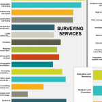
The NSPS questionnaire yields constructive feedback. This column provides monthly coverage of a national initiative: Forum on the Future of Surveying (FFOS). See the first installment in our March issue. The National Society of Professional Surveyors released a short, online questionnaire in April to gather feedback in advance of the second meeting of the national […]
A State Gets Smart: SmarterBetterCities
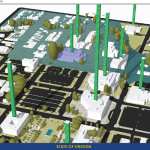
To create and share interactive 3D building models, Oregon adopts SmarterBetterCities. To help formulate a 10-year strategic capital investment plan for the State of Oregon, the state’s Chief Financial Office (CFO) wanted to develop a dynamic, immersive, and collaborative visual platform that would illuminate key issues often lost in a tabular summary. Its audience was […]
Fluid Data: GNSS and iPads

Lawrence Spencer puts the Trimble R1 GNSS receiver and iPad to work on the Kissimmee River. Pairing GNSS with iPads opens seamless data flows for a water management district in Florida facing wetlands complexity. Lawrence Spencer first joined the South Florida Water Management District’s (SFWMD) lake and river ecosystems section in 2006 as a […]
Demystifying Mobile Mapping

Above: A mobile mapping rig of the engineering consulting firm Tetra Tech; the crew mapped the entire 288 miles of roadways in the city of Redmond, Washington in six days of driving. A surveyor examines (and asks users a lot of questions about) the Pegasus:Two system. Editor’s note: How could measurements taken from a moving vehicle […]
UAS & The Combo that Opens Access

The most logical integration of technologies for surveyors is combining 3D laser scanning with UAVs. It’s no secret that many geospatial professionals are enamored with unmanned aerial systems (UAS). For many years, the pros and cons of deploying small UAS for mapping and surveying, along with their ongoing regulatory discussions, have been well researched and […]
3D, GIS, VR… We’re in Cloud City
When the father of GIS, the late Roger Tomlinson, first imagined a computerized system for handling land inventory mapping more than half a century ago, did he imagine that GIS would become such an integral part of our lives? At a click of a button, we can access directions to where we want to go, […]