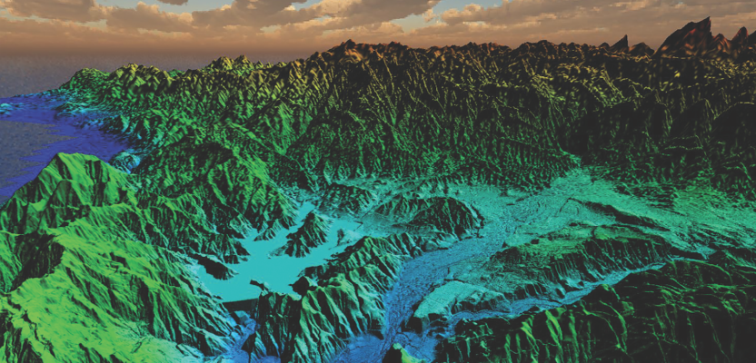
After the 2018 wildfires in Southern California, lidar data was collected to enable risk-mapping assessment and planning, to identify fuel-load reduction programs, and to escalate the emergency assessment of post-fire debris flow hazards.
Featured image: This lidar image was taken over Lake Casitas, California.
The data are clear: Natural disasters are on the rise, and their impact is increasingly devastating. According to the National Centers for Environmental Information (NCEI), between 1980-2019 the U.S. averaged 6.5 weather and climate disaster events with costs exceeding $1 billion each. The total cost? More than $1.75 trillion.
The need for lidar data is also clear. Lidar provides high-resolution elevation data and has been proven to be a powerful tool that can mitigate the impact of these disasters. This highly accurate data is used to create detailed topographic maps that support risk analyses, modeling, resilience, recovery, and planning for everything from hurricanes to earthquakes to wildfires.
To fully understand this application, especially where wildfires are involved, a group of U.S. Geological Survey (USGS) and Woolpert staff sat down to discuss experiences and review materials related to this relationship.
Wildfires have been increasingly devastating in select areas of the country, especially over the last few years. Between 2017-2019 alone, the NCEI reports that costs incurred by wildfires predominantly in California have totaled more than $47.7 billion and claimed more than 160 lives.
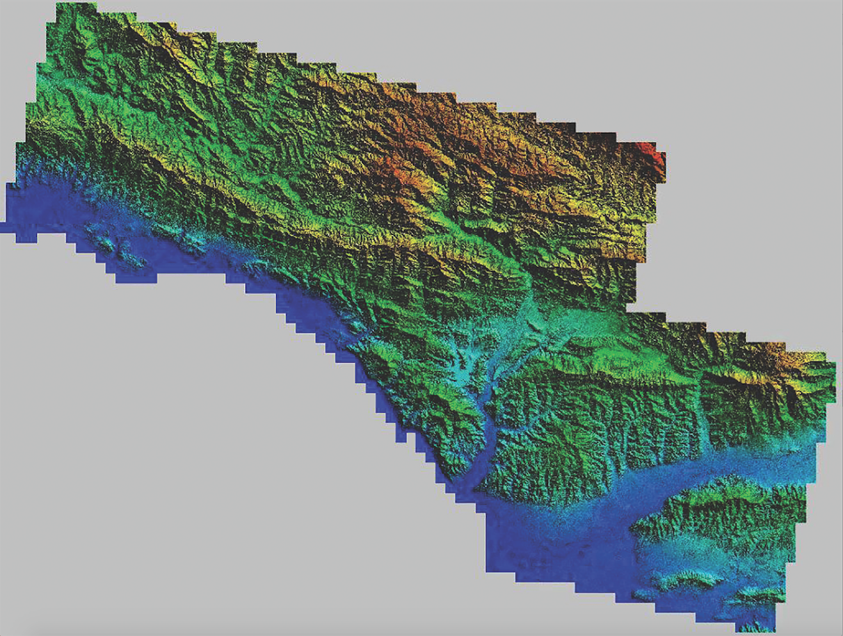
USGS 3D Elevation Program (3DEP), in partnership with the Federal Emergency Management Agency (FEMA), contracted with Woolpert to collect, process, and deliver roughly 9,500 square miles of lidar data across Southern California immediately following the wildfires that raged across the region in 2018.
The data were collected to enable wildfire risk mapping assessment and planning, identify fuel-load reduction programs, and escalate the emergency assessment of post-fire debris flow hazards.
“Increasing frequency and intensity of wildfires across the state of California highlight the urgent need for additional high-resolution elevation data to support disaster relief and recovery efforts—and to anticipate future hazards,” said geographer Carol Ostergren from the USGS National Geospatial Program.
“We have used older elevation data, satellite imagery, aerial imagery, and other tools in the past, but the none of those deliver the high-resolution fidelity of aerial lidar data, especially for post-disaster response.”
Lidar data provide 3D information about the forest canopy and vegetation structure. Credit: United States Geological Survey.
The Science behind Wildfires
In 2019, the American Meteorological Society cited climate, fuels, and people as the three confluent factors for the destructive wildfires that have plagued California over the last few years. Although these factors are difficult to control, scientists have identified resources that address how wildfires escalate and cause catastrophic damage.
Wildfires spread quickly, powered by thick, dry vegetation, to destroy everything in their path. They remove the vegetation that holds the earth together, destroying fine scale roots several inches deep. The fires can change the properties of the soil, making it more susceptible to erosion and adversely affecting how the ground absorbs water.
Wildfire risk mapping and planning assessment requires analysis of a lidar dataset in order to determine the vegetation, fuel load, and potential structures that are in danger for future events. Fuel-load reduction programs aim to lessen the material that contributes to the propagation of a wildfire.
“Imagine a large pine tree with branches that reach the ground,” says Dennis Staley, a research geologist at USGS. “If the fire catches, it goes up to the top of the tree. However, if the tree has been trimmed from the ground up to about 12 feet, it reduces the risk of that tree catching fire and of that fire spreading.”
One way to decrease the fuel load is to reduce the understory that grows beneath the forest canopy. By identifying, creating, and maintaining fire breaks, a wildfire can be mitigated, slowed, or even redirected. By strategically decreasing these fuels from targeted areas, like near homes and businesses, the likelihood that the wildfire will destroy those structures is considerably lessened.
Lidar collections captured post-fire not only help address recovery efforts, but they help plan for future events. By identifying fuel load and the canopy structure of vegetation, adjustments can be made to predict and focus efforts on the path of future wildfires to protect people and infrastructure.
Change Detection after Fires
Wildfires also spark other potentially devastating natural disasters. FEMA reports that wildfires dramatically alter the terrain and greatly increase the risk of flooding from heavy rains and mudflows.
The USGS Landslide Hazards Program (LHP) has two primary objectives: to advance the understanding of post-fire debris flows and improve the ability to predict the likelihood and magnitude of debris flows.
“To understand post-fire debris, we need to understand how landslides initiate, how they propagate downstream and how the runout inundates downstream areas upon exiting a mountain front,” Staley said. “To predict debris flow, we have to also understand the rainfall intensities that initiate that debris flow in recently burned areas.”
To perform change detection after fires, the LHP conducts multiple studies assessing topographic, hydrologic, and vegetation changes in the days, weeks, months, and years following wildfire. Staley also stressed the overall importance of the emergency assessment of post-fire debris hazards.
“We have some fairly simple statistical models generated from data collected in the immediate aftermath of the fire to estimate the rainfall impact and the likelihood of flooding or even future fires,” Staley said. “Models applied between 7 to 10 days after the 100% containment of the fire provide immediate resources to these organizations.”
These studies leverage lidar data—both terrestrial and airborne—unmanned aircraft system (UAS) data, remote sensing data, and direct field measurements of surface and subsurface hydrological properties at monitoring sites of two years or more.
Where Lidar Comes In
Lidar data provide the necessary 3D information about the forest canopy and vegetation structure, which is used to map wildfire fuel like trees and clusters of trees that are more likely to burn and escalate a wildfire.
“Collecting data after a wildfire helps develop predictive models of flood and mudflow hazards that result from steep terrain that has been stripped of vegetation,” Staley said. “When the vegetation, whose root network holds the dirt together, is burned off, it turns into mudslides.”
Lidar data support the fundamental science of how flows initiate, how they grow and evolve, and where they go. Statistical debris flow models, generated by lidar data, illustrate the likelihood and rainfall intensity thresholds of a region.
“We rely on 10m digital elevation models because they’re available and models are calibrated,” Staley said. “We use lidar in the recently burned areas. Data on topographic boundary conditions for field work support boundary conditions for process and physics-based modeling for analysis.”
Lidar data collected before a wildfire is used to predict and address the fire’s behavior, path, and intensity. The data collected after a wildfire is used to analyze hazards created by the fire, such as flooding and mudslides. It can be used to identify fallen trees within the understory and, when combined with hyperspectral or other imagery, the vegetation health and point density of the upper canopy can be mapped to predict fire susceptibility.
“Lidar helps analysts calculate fire risk and to identify regions where prescribed burns can prevent greater damage,” Staley said. “Regular forest management involves knowing the topography and creating fire breaks, removing ladder fuels, and implementing defensible space around homes and businesses.”
To help mitigate landslide risk across the state, more widely available lidar data—and more data overall—are needed. Improved resolution and accuracy of data related to both bedrock and surficial geology is necessary to combat these natural disasters.
Collection and Application
As the firm contracted by the USGS to acquire the lidar dataset, Woolpert mobilized to Southern California to acquire airborne lidar over a region of interest for wildfire mitigation analysis.
During the collection deployment, the team faced numerous challenges. These included difficult and varied terrain, significant airspace restrictions, and frequent environmental factors, such as daily interference from a marine layer of fog, as well as new wildfires that had initiated during the acquisition time frame.
Ultimately, a 3DEP quality lidar data set was acquired, processed, and is now publicly available and distributed by the USGS.
This collection supported multiple state and federal agencies, which each benefit from the use of the lidar data for wildfire mitigation, recovery efforts, and new mapping. These include the California Department of Forestry and Fire Protection, the U.S. Forest Service, the National Park Service, the Department of Fish and Wildlife, the California Geological Survey, and the National Weather Service, as well as local agencies specific to the event.
The lidar data are being used to analyze hazards created by the fires, such as flooding and mudslides, and will be used to analyze future risk mitigation strategies.
Lidar data can be integrated and applied using several commercial software packages, including ArcGIS, TauDEM, and Python software for the assessment of post-fire debris-flow hazards. For data related to post-fire debris flows, Matlab, IDL, LASTools, SAS, and others can be used.
By producing information that directly supports the objectives of the USGS and the FEMA Flood Hazard Program, the benefits of collecting, processing, and analyzing lidar data are evident. To quantify and qualify that return on investment, the 3D Nation Requirements and Benefits Study is gathering updated estimates on potential benefits from topographic and bathymetric lidar data. The study will be completed later this year.
Lidar is one of the most crucial tools in this battle against natural disasters which, as the data have shown, will only continue to grow and impact lives and livelihoods well into the future.
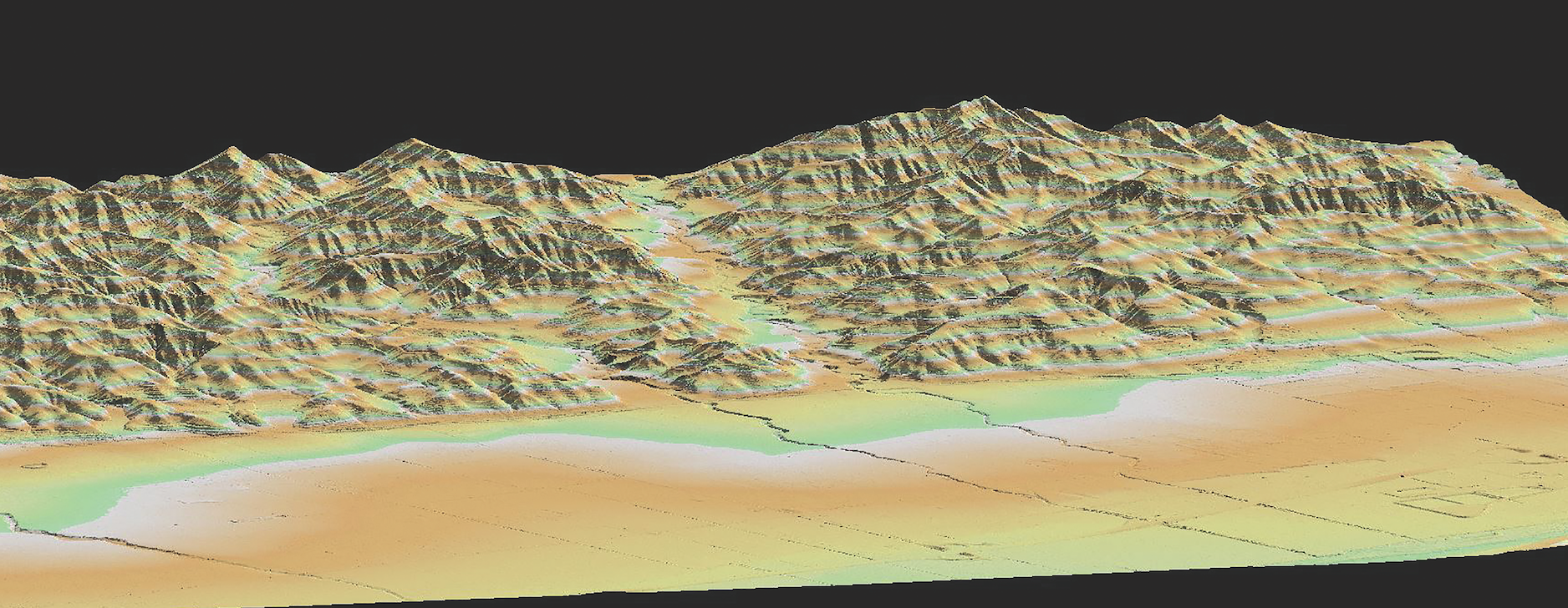
Lidar collections captured post-fire such as this help address recovery efforts and plan for events like mudslides. Credit: United States Geological Survey.
CAL FIRE Needs Imagery
In its 2019 “Community Wildfire Prevention & Mitigation Report,” The California Department of Forestry and Fire Prevention (CAL FIRE) called for the use of lidar, satellite, and other imagery and elevation data collection, processing, and analysis for incorporation into state management plans and emergency response.
The report concluded that living sustainably in the fire-prone landscapes of California will require broad recognition of the inevitability of fire, which will in turn necessitate enhanced investment in and novel approaches to risk evaluation, fuel management, forest health, land use planning and community adaptation.
“As we move headlong through the 21st century, fire managers and landowners in California are challenged to effectively utilize available resources and tools to create resilient landscapes, reduce loss of life and property, and stem rising management costs, while enhancing our compatibility with the fire environment in which we live.”