Fueled by the convergence of cloud computing, digital automation, and internet distribution, subscription mapping creates new opportunities.
Subscription aerial mapping sets out to rid the industry of its dated legacies. One in particular is the commissioning of aerial mapping projects. The process can be bureaucratic, expensive, and subject to a long approval. This could lead to delays and inconsistency in data deliveries, which is especially critical for end-users whose aerial imagery needs are based on seasonal conditions.
A second legacy is that single-project aerial mapping is not economically viable for industries such as solar and construction that want pockets of small areas and are hyper-interested in updates and changes over time.
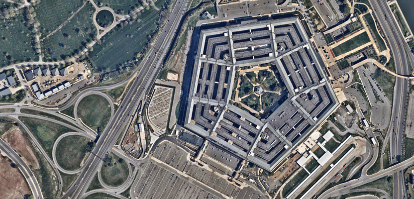
The Pentagon, the headquarters of the U.S. military, as captured by nearmap.
Lastly, the aerial mapping industry is further complicated by fragmentation. Aerial imagery collection, data processing, map creation, and GIS analysis are completed by a variety of organizations that offer a combination of one or many of such services. An end-user has to make the decision whether to retain part of such services in-house even if mapping is not their area of expertise. Depending on their capabilities, traditional publishing times for a single mission could take up to five months.
So why are end-users of aerial mapping data turning to software as a service (SaaS)? Their reasons are in line with why the entire software industry is moving to the cloud. Once the user subscribes to an on-going mapping service, they need to approve it only once and forego commissioning over multiple years. SaaS enables a consistent, simple, and scalable budget item. Then, software access is simply through a web browser, eliminating the hassle of purchasing and maintaining single-desktop or server licenses. Software upgrades are simply part of the service.
Also, the end-user forgoes the need to build a private and expensive IT infrastructure. They don’t need to maintain an in-house server network along with specialized staff. The end-user can flexibly scale their operations without the need to upgrade and change hardware. Large-scale security adaptability and response are handled by the SaaS company.
Today, SaaS companies can disseminate products to a larger pool of potential users and bigger markets through a simple browser and internet connection. Most importantly, their user base is conditioned to web services and is unafraid to migrate to it.
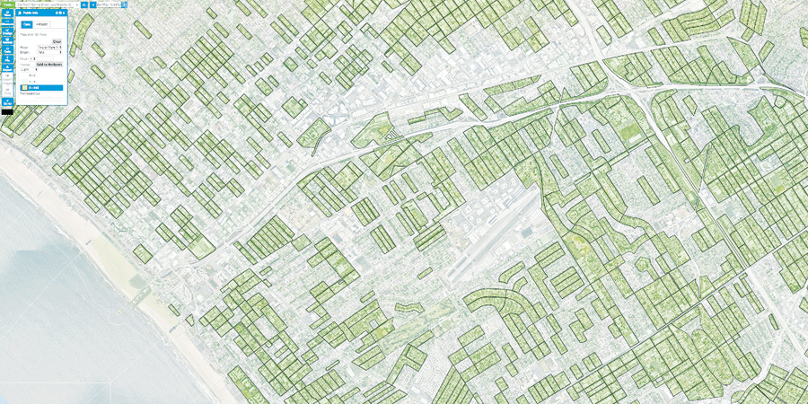
For the Los Angeles area, nearmap’s service combines their imagery with census data.
nearmap
One of the companies tackling these opportunities is Australia-based nearmap, a visual analytics company that offers a cloud-based subscription service, targeting businesses via frequent, high-resolution, and historical aerial imagery. They produce georeferenced images of populated urban areas updated three to six times per year at better than 2.8 inch (7.1 cm) GSD. Users have access to all its data archives over the same area, allowing for temporal change detection.
For all its offerings, nearmap’s subscription service is currently based on a pay-as-you-consume pricing. nearmap has been successful with this business model in Australia, reaching 89% of its population. It’s expanding into the U.S. market, even relocating its management team to San Francisco, now reaching 50% of the U.S. population.
To service their wide range of customers, nearmap has a fleet of aircraft and camera systems to capture urban areas based on a schedule to revisit multiple times per year. Their in-house camera and pod systems go hand-in-hand with their proprietary mapping workflows. This integration of software, hardware, and data processing enables them to fly an area and publish the map three to five days after a flight. In Australia, nearmap provides orthophotos and oblique imagery. In the U.S., they are currently providing orthoimagery, but have plans to offer more.
As industry veterans will recall, many companies, both aerial and satellite, have tried similar subscription mapping services. They flew certain areas non-commissioned, then tried to sell the data to multiple clients. However, there is a graveyard of such companies. The high costs of operations and map production, the inability of one-size-fits-all accuracies (too many different types of customers), and a dependency on government as clients made mapping as a service very difficult to sustain. Crucially, internet connections, speeds, and access were issues that even a decade ago hampered dissemination and market size.
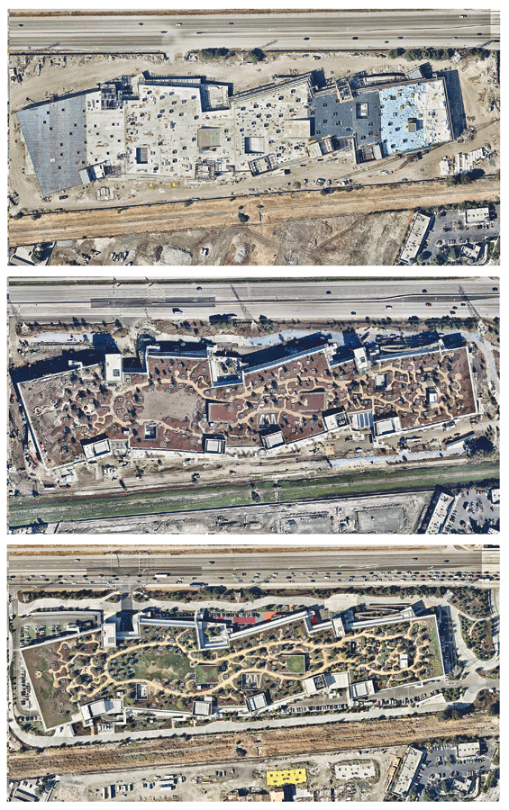
Facebook used nearmap’s mapping as a service to document the progress of its new campus.
What’s different this time are a few aspects of the internet age that may tip in favor of companies like nearmap. These reflect the big changes that the entire software industry is experiencing: people are moving onto the cloud as high internet speeds, Wi-Fi, and mobile internet have become expectations and mobile devices have become our primary computer.
Expanding into Vertical Markets
For a provider like nearmap, SaaS allows the provider more opportunities for several revenue streams: organizations can build web services on top of their platform, they can simply sell the imagery, and they can build software-specific tools for a niche market. These reach different types of end-users who have a range of geomatics skills.
Geospatial professionals who may not have the means to easily commission data collections may benefit from nearmap’s imagery content and cloud-based repository. With a steady stream of fresh imagery, the geospatial professional can use nearmap’s platform integrated with existing GIS workflows such as Esri ArcGIS solutions on a desktop and online.
However, a compelling part of nearmap’s platform is the creation of sector-specific web tools; these address the painpoints of non-geospatial end-users who would not otherwise have used aerial imagery and GIS. Speculatively, the capability to reach this kind of audience is the biggest difference from anything that has come before by complementing and also bypassing the fragmentation of the traditional industry.
An area of fast growth is providing a purpose-built, decision-making tool for industries that depend on on-site inspections. These are generally not users of aerial mapping. On-site inspections can be a considerable expense and hassle depending on the frequency, cost, and travel time of visits, the number of inspectors required, and the inspectors’ salaries. As a result, nearmap currently serves solar, construction, property assessment, and insurance professionals to reduce and eliminate on-site inspections.
For example, their solar offerings help solar professionals prepare quotes by measuring home roof areas, use a library of solar panels to assess the requirement and supplier costs, and model energy output based on a historical record of sun angles. Their construction module enables building professionals to remotely assess project status, prepare quotes, perform cost estimation, and produce general interest updates. Insurance and government property assessors can measure and observe properties over time.
Mapping information is simply the catalyst for revenue generation tools. In this regard, nearmap has evolved from a pure imagery business to an applications and analytics company. In addition, these new markets are populated by a much greater number of small to medium businesses, which increases the potential user-base dramatically, allows for much easier scaling, and shortens the sales cycles.
In theory, if the cost of data acquisition decreases while automation and coverage increases in markets with a great number of users, then subscription services make a lot of sense, especially if a product is compelling. The global software trends seem to point in that direction.