All posts by Matteo Luccio

Aerial Self-sufficiency
Above: Universal Studios, Florida A large risk-assessment and data-analytics company created its own internal system to collect imagery, write software, and develop processing workflows. If a private company or public agency is large enough, it may be able to internalize all of the processes for its services rather than having to outsource any. For example, it might...

Street Views of the Water
Above: Martin Offenhauer surveys the Big Rock Road section of the San Diego River. Credit: SDRPF. Mapping rivers above and below the surface creates great opportunity for engineers and stewards. The way maps are produced and displayed varies greatly, depending on their extent, their intended use, and the peculiar challenges of each environment. Mapping a...
After the Storm
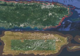
Above image: Puerto Rico was surveyed using the Coastal Zone Mapping and Imaging Lidar system to provide efficient damage assessment. Image courtesy of the Joint Airborne Technical Center of Expertise. Post-hurricane coastal mapping is a complex process made easier with airborne bathymetry. Lately, large storms such as hurricanes, cyclones, and typhoons have been wreaking havoc...
mESRIsoft
More than partners, Esri and Microsoft collaborate and combine platforms to benefit their users and the public. From their CEOs, Jack Dangermond and Satya Nadella, down to the individual developers and field sellers, Esri and Microsoft work together very closely. “We are connected at almost every level to each other’s companies,” says Lea Ann Thurman,...

Not Everything Requires High Accuracies
How feature inspection, assessment, and reporting are now available to non-experts (and experts alike). In the early 2000s, Leon Toorenburg was in Africa mapping the locations of communications and utility towers. He was carrying a laser range finder, a camera, a GPS receiver, a laptop, and a field stick. It occurred to him that there...

Where the Data Comes From
Members of Esri’s Living Atlas unit detail the company’s wide variety of data sources. For nearly 50 years, Esri has been developing and supporting GIS software. What is less known is that for more than 20 years it has also been collecting and curating data and making it available to its users. “It has become...