AECOM professionals adopt an integrated approach to best leverage the most current digital technology tools.
With many aspects of the nation’s infrastructure reaching the end of its as-designed life, and with the purchasing power of construction dollars continuing to be stretched, developing systematic processes for determining the most cost-effective infrastructure investment strategy is critical.
“Scan-to-BIM” and “Reality-Capture” are terms we use to define what we do in our day-to-day work for scanning and surveying technology advancement in all forms of measuring practice. Precise measurement and photogrammetry combined into one single-source of truth that can then be interpreted and translated into a documentable digital reproduction, or “digital-twin” that represents the actual artifact in time and space is part of our typical workflow.
Certainty of Form
3D technology and software have existed for decades. Introducing newer and more comprehensive technology provides enhanced design certainty (in particular for geometric aspects) on a project whether greenfield, brownfield, or existing conditions inventory and assessment. For example, BIM with lidar reality capture elevates the life-cycle management of the asset from the start. Geo-spatially referenced data capture of existing conditions and as-built geometry (via lidar scanning and other methods) provides geometric accuracy and can provide component data for integration into the digital twin.
At AECOM, we use lidar as the foundation of the Certainty of Form process. Many other companies do as well, but the expected outcome or deliverable mode, means-and-methods, and desired work-result may vary. The power of the tools and technology available, if properly integrated, and the resources available for more accurate extraction from scanning are in constant development for innovative applications.
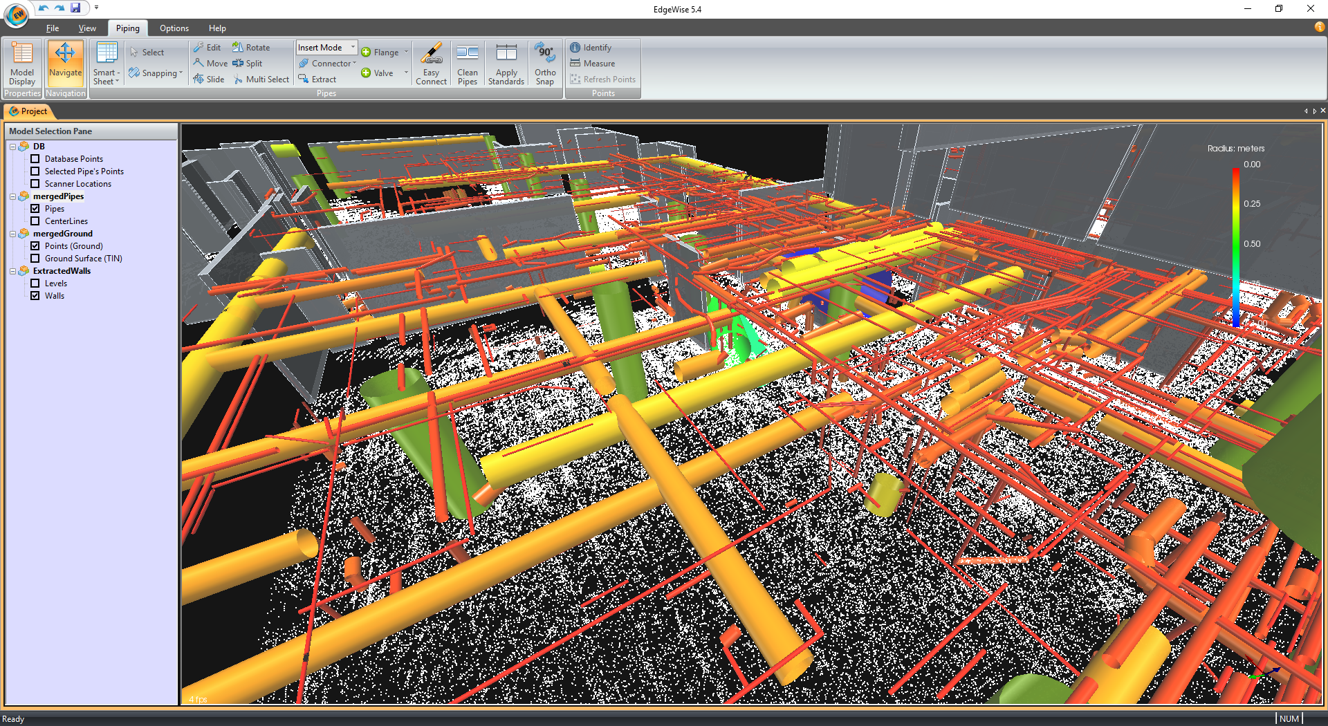
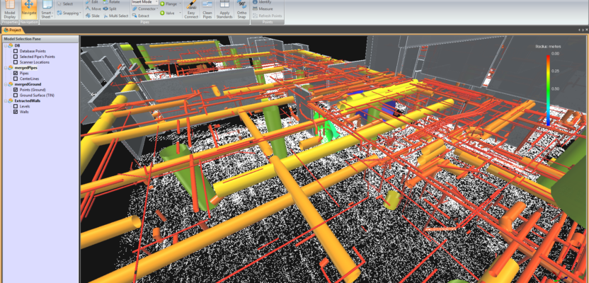
Point cloud processing in EdgeWise database with extracted elements from the point cloud database overlaid to the point cloud.
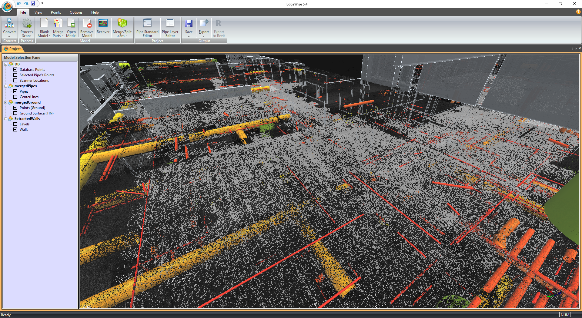
Point cloud processing into EdgeWise database with extracted elements from the point cloud database only
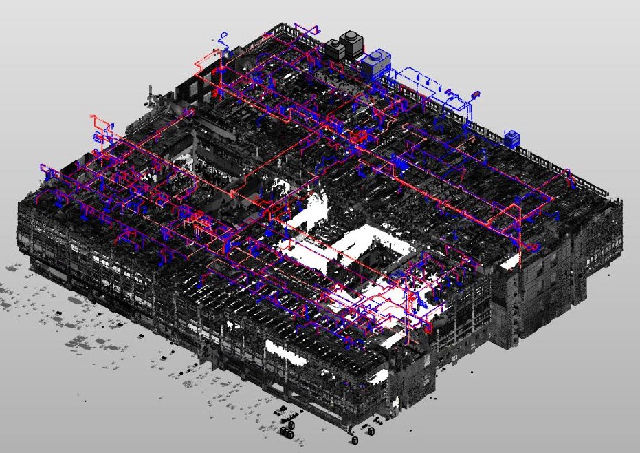
EdgeWise database with extracted elements from the point cloud—used modeling and transferred to design-authoring software like Revit.
Certainty of Quantity
The workflow for design and construction needs to support all stages of the asset management process: condition assessment and data capture, data analysis, deficiency identification, cost estimating, capital investment planning and project prioritization, and OPEX budget modeling. In the past, complex tasks like organizational and operational planning, space optimization, and climate change resilience were time consuming, but with digital innovations, this can be achieved much more quickly with more in-depth analysis starting with lidar scanning. Providing the greatest level of interoperability between common data environments and technology stack for effective project collaboration and delivery is key.
Certainty of Safety
An understanding of the scan-to-BIM process involves a clear understanding of what has to be captured, the level of accuracy (LOA) required for the desired work result, and a clear understanding of the level of development (LOD) of the final deliverable. Mis-planning with set-ups or positioning, or, worse yet, improper post-processing, could lead to errors in the accurate capture and representation of geometry and geo-spatial measurement and relationships that can then migrate bad data into the designer or modelers hands due to design software limitations and functional constraints.
A critical part of our workflow involves the use of the Leica® RTC360® (two million points per second, max resolution (three millimeters at 10 meters), range six inches to 426 feet, average scan two minutes = 240 million points), or the Leica® P40® (one million points per second, max resolution (0.8 millimeters at 10 meters), range one foot to 885 feet, average scan nine minutes = 540 million points) to safely and accurately capture hard-to-measure spaces and elements with a very high level of accuracy.
Certainty of Modeling
To support modeling certainty from our reality capture, our Digital Design and Technology group utilizes ClearEdge3D’s EdgeWise® technology as part of our modeling technology stack to aid in cost-effective use and expansion of labor, reduction in time for accurate production, and increased LOA into LOD.
Additional outcomes have the reduction in user error or rework from the interpretation of geometry and geospatial relationships, but also as a quality assurance tool for use in downstream design and clash-detection for accuracy through innovative interaction between the EdgeWise® database information, the post-processed point clouds, and the 3D models in Autodesk® Navisworks Manage®.
Real-life application examples of where the EdgeWise® technology and the accuracy of their algorithm for extraction have been critical environments, like power and water treatment facilities, hospitals, and technology-orientated spaces where piping and conduit are often dense, vertically stacked and relatively obscured, and run extensive lengths with high amounts of twists and bends.
These environments can also provide high-level Gaussian-effect (magnetic resonance) of the field scan data, making it challenging for a user to properly interpret and model from. The EdgeWise® product, with appropriate settings, has eliminated the Gaussian-effect issue by accurately extracting geometry aligned with where panographic images show it needs to be.