November 2020 Archives
Surveyors Saving the Wild Pecos River from Itself
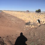
Survey helps protect land and wildlife from New Mexico river flooding “Well we can make it to the road in a homemade boat Because that’s the only thing we got left that’ll float It’s already over the wheat and the oats Two feet high and rising’” —Five Feet High and Rising by Johnny Cash If […]
PDR and the Pandemic
What continuing education will look like in the post-Covid-19 world Our Professional Development Record (PDR) hours—CPD in the UK—are a key part of the surveying and geospatial professions. Previously PDR would have involved a mixture of in-person training, in-person conferences and self-study training materials. With the Covid-19 restrictions on meeting other people face-to-face, meetings are […]
The Return of Loran

An obsolete WWII navigation system is making a comeback In the 1980s, I used Loran-C to navigate on sailing trips off the U.S. East Coast. It had an accuracy of a few hundred feet and required interpreting blue, magenta, black, and green lines that were overprinted on nautical charts. The system was a modernized version, launched […]
The Early Days of 3D Scanning, Part 6
1998: Launching 3D Laser Scanning into the Market I had the good fortune to be deeply involved with a pioneering vendor of 3D laser scanners and point cloud software. As I consider where that technology is today – a multi-billion dollar per year industry, the valuable benefits it has delivered to so many organizations and […]
Grand Surveying in Grand Paris
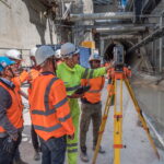
Advanced solutions for tunneling and monitoring keep Europe’s largest transportation expansion project on track All photos taken prior to introduction of COVID-19 distancing guidelines Paris is grand—and getting much grander. One of the most visited—and loved—cities in the world, The City of Light began the Grand Paris initiative in 2007 with the goal of keeping […]
The Scan-to-BIM Process: Capture and Extraction
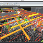
AECOM professionals adopt an integrated approach to best leverage the most current digital technology tools. With many aspects of the nation’s infrastructure reaching the end of its as-designed life, and with the purchasing power of construction dollars continuing to be stretched, developing systematic processes for determining the most cost-effective infrastructure investment strategy is critical. “Scan-to-BIM” […]