
Blog

GEO Business 2017 – Exhibition Preview
Next week, from May 23-24, GEO Business, the UK’s biggest geospatial exhibition and conference of the year, returns to the Business Design Centre in London. Over 3,000 visitors, from 67 countries, will be there to discover the latest new products, services and solutions from 200 leading industry innovators. Attendees will also have chance to meet...
Robots for ExoMars: Drones and Space Exploration
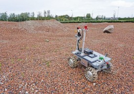
Drones are being used to test a space rover in familiar ways. By Martin Azkarate UAV manufacturer senseFly talked to Martin Azkarate of the European Space Agency about his work developing rover prototypes for planetary exploration, including how he employs a senseFly drone to test these cutting-edge robots. Martin is a space automation and robotics...

xyHt Weekly News Recap: 5/12/17
MKS’ Ophir® Business Unit Introduces Smallest, Lightest Weight, Continuous Zoom Lens for Drones & UAVs Swift Navigation and Carnegie Robotics Announce Duro, a Ruggedized Version of Piksi Multi Announcing UgCS Mapper – in-field mapping software requiring no internet connection Septentrio launches AsteRx-m2 OEM GNSS Receiver Alta Devices Adds Solar Tech to Drones/UAV’s to Extend Flight...

“Next Big Thing” in Surveying Winners: Cyberpunk Dreams
When publisher Neil Sandler initiated the “Next Big Thing” essay contest in January, we were pleasantly surprised at the wide variety of entries. Because we hadn’t specified if the essays were to examine what the next big thing “will be,” “could be,” or “should be,” we got a mix of all three, from surveyors proposing what...
Straight on to Mars (and Beyond)
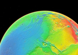
In the last issue we raised the question of whether mankind should go back to the Moon as a way to fuel future space exploration. While that article states the many salient reasons to take this path, many people feel we should aim higher and go straight on to Mars. (For insights on what geospatial...
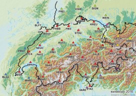
GNSS Network SWIPOS Continues to Lead the Field(s)
One of the oldest and most successful real-time GNSS networks continues to lead in providing precision and reliability for surveying, mapping, geodesy, science, and more. By Gavin Schrock, PLS In the early 2000s, when the first RTN were being introduced in North America, network developers would rely on the experience of their peers in Europe...
Advertisement