
Blog
Higher-ed Profile: Idaho State University
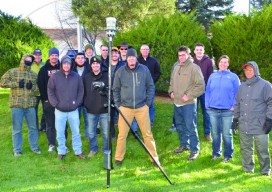
Surveying and Geomatics Engineering Technology By Adam Thayer One of the many things I enjoy about this program at Idaho State University (ISU) is the history and investigations involved with surveying, specifically boundary surveying. There is nothing quite like finding an original stone or visiting a monument that hasn’t been uncovered since it was originally...

Pokemon Go: Geography Professor Pikachu?*
The single largest coordinated global geo-education event might just be … Pokémon GO! *Yes, aficionados have been quick to point out that the professor in the app is Professor Willow, but many readers might only connect the name Pikachu with the world of Pokémon. The title was intended to be a bit tongue-in-cheek. Below is...

xyHt News Links: 7/8/16
Reduction of the Nationwide Differential Global Positioning System (NDGPS) FAA to Answer UAS Rule Questions at MAPPS Summer Conference Trimble R2 GNSS Receiver Now Available for Data Collection Trimble Adds Fully Automated Scheduling Capabilities to its Advanced Solution for Field Service Management Dewberry completes US hydrography study for business uses, requirements
Higher-ed Profile: California Polytechnic University, Pomona
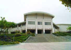
Geospatial Engineering Program By Dr. Francelina A. Neto, PLS The Cal Poly Pomona College of Engineering offers 11 undergraduate and five Master of Science degree programs housed in seven departments. Serving over 5,000 students, the college is the 17th largest in the nation. The civil engineering department currently has two programs: Civil Engineering (CE) and...
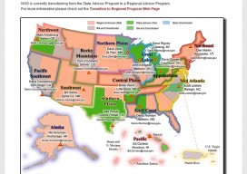
State Geodetic Coordinators: An Important Emerging Position
As the National Geodetic Survey (NGS) completes its transition from the State Geodetic Advisor Program to the Regional Advisor Program by the end of 2016, the states are changing their roles with NGS as well. In the past, the participating states have been contractual partners with the NGS, providing roughly half of the funding...
NSPS Map/Plat Design Competition Winners
2016 Map/Plat Design Competition NSPS is pleased to announce the winners of the 2016 Map/Plat Design Competition and expresses its appreciation for all who participated. NSPS also wishes to thank the judges for their dedicated efforts. Subdivision Plats First Place: Harry Smith – Northeast Surveying, Inc. – Wisconsin Second Place: Kyle Mott – BME Associates...
Advertisement