
Blog
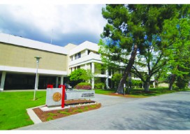
Higher-ed Profile: California State University, Fresno
Geomatics Engineering Program By Scott Peterson and Stephen Castillo California State University, Fresno (Fresno State), offers a Bachelor of Science degree in geomatics engineering, with no two-year option. Upon graduation, students are expected to enter a plethora of fields that include geodesy, land surveying, photogrammetry, remote sensing, geographic information systems (GIS), and global positioning systems...
And… Geospatial
And is a powerful word. Compare it to or. Few choices in life are as limiting as paper or plastic. When it comes to our professions, the services we provide, and the markets those services represent, it may be a bad idea to impose limitations on ourselves. Perhaps we need to take a deep breath...
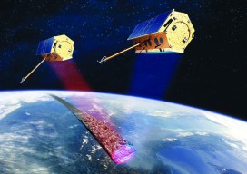
InSAR
How can you monitor broad-area land deformation with high precision? Why, from space, of course. Is it possible for satellites to accurately monitor the motion of landscapes with millimeter levels of precision? What about over wide areas while being frequently updated? If you scoffed in response to either of these questions, you might be surprised....

xyHt News Links: 7/1/16
Topcon announces improved efficiency with Autodesk workflow Septentrio Offers Enhanced Georeferencing Solutions for Drone Aerial Surveys Let’s Make the World a Better Place with Maps Trimble Announces Release of TDC100 Handheld GNSS Data Collector DigitalGlobe and Esri Announce New Long-Term Partnership to Expand World Imagery Map Spectra Precision MobileMapper 50 Combines Smartphone Design with Professional...
xyHt Magazine July 2016 Issue
Click here to view the July 2016 issue of xyHt magazine.

Trolling: Always Get Independent Advice & Avoid the #geotroll
Ever since I started tweeting and blogging, I’ve received messages about using certain software, or how expensive a software is, or sometimes threats over my choice of software. It falls on deaf ears; I am independent. ANY geospatial software, no matter cost or design, is worth considering to some respect. Sure, some may meet your...
Advertisement