Category Archives: Lidar/Imaging

Embracing the Drone Revolution
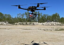
Surveyor business models changing in the BVLOS era Over the past few months, the Federal Aviation Administration (FAA), working with the drone industry, academia, and general aviation membership organizations such as AOPA (www.aopa.org) and NBAA (www.nbaa.org), has been able to advance the cause of uncrewed flights beyond visual line of sight of the operator (BVLOS). ...

Repositioning GIS
The technology that will drive the next era Esri calls GIS the nervous system of the planet, a platform relevant to almost every human endeavor. It’s a way to display, manipulate, and analyze geospatial data—and that ability is ever changing and expanding across industries. GIS technology allows us to derive location intelligence from spatial and...

What to do With All the Lidar Data
An age-old Aesop’s Fable adage says, “Be careful what you wish for, lest it come true!” When the U.S. Geological Survey (USGS) embarked on the National Enhanced Elevation Assessment (NEAA) in 2012, the goal was to document the national-level requirements for enhanced elevation data. Little did USGS know at the time, the report would be...
Teledyne Forms New Geospatial Company
Teledyne Optech and Teledyne CARIS have united to form the new Teledyne Geospatial, offering holistic solutions to seamlessly map land and sea through the integration of industry-leading lidar sensors and world-renowned software workflows. This collaboration empowers customers with a competitive edge in mapping and delivering data products inside of one complete workflow.Ease of collection and...
Maps As Art
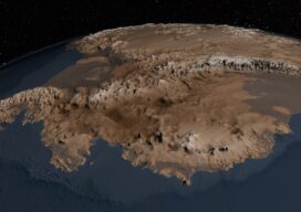
Under Antarctica’s Great Ice Sheet The topography of the bedrock under the Antarctic Ice Sheet is critical to understanding the dynamic motion of the ice sheet, its thickness, and its influence on the surrounding ocean and global climate. In 2001, the British Antarctic Survey (BAS) released a map of the bed under the Antarctic Ice...
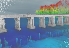
Fusing Aerial and Mobile Lidar Data
Creating accurate as-builts of a complex facilities is no longer a long-term project. When the Caltech Group was founded by two men in Calgary, Alberta, in 1990, they set out with the goal of becoming Western Canada’s go-to company for geomatics services with an eye on specializing in the oil, gas, and utility areas—those companies...