Category Archives: Surveying
Amanda Askren
Amanda Askren, PLS – Survey Manager, the City of Renton & Young Surveyors Network (YSN) US Coordinator – Washington, USA If there is a committee or conference to organize, Amanda will be there. An accomplished surveyor, Amanda received engineering and geomatics degrees from Purdue University and has garnered professional awards, including the Surveyor of the...
Alasdair Begley
Alasdair Begley – Director – Saunders Havill Group – Australia Alasdair Begley views the design and development of commercial and public projects in a holistic manner and develops solutions to challenges— approaching each as integral parts of the design process rather than compartmentalized independent tasks. And with his bachelor’s degree in surveying from the Queensland University of...
Gus Porter
Gus Porter – Vice President, Sawtooth Land Surveying – Idaho, USA Gus Porter views change as an opportunity, not only for his company but for his profession. Gus is a third-generation land surveyor who began surveying during his school breaks at the age of 14 and started his company with his dad. He says he’s been fortunate to...

SHS 2015 Rendezvous
This past September, surveyors gathered to learn about and participate in the history of the Washington/Canadian border and the San Juan Islands. It was a fun and exciting time this year at the Surveyors’ Historical Society’s (SHS) annual rendezvous. Amidst the beautiful scenery of Washington State, surveyors from all around the country gathered for a...
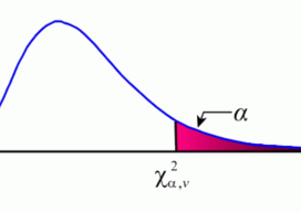
Sampling Statistics
The Chi-squared Distribution In my most recent article (August 2015), I discuss Student’s t distribution and how its properties can be used to isolate blunders in observations. Another sampling distribution that is commonly used in least squares adjustments is the χ2 (chi-squared) distribution. It appears in the form of what is typically called the “goodness of fit”...
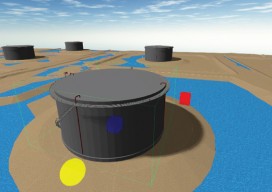
True 3D Design
New geospatial software combines the appeal of games with the rigor of applications. It’s never been done before: applying the rigor and disciplines of civil engineering, mining engineering, hydrology, and even classic survey field-to-finish to game-like 3D design. Sure, CAD operators have had 3D viewing for years, which they use to review the results of...