Category Archives: Surveying
The Beaten Path
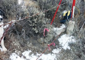
Art of Retracement With a set of eyes that had focused on survey lines through several eras, the Old Man (Glenny Dale, also known as Glutton), took one look at the cluster of three monuments along a right-of-way fence line. The site of three pins at a point where there could be only one legal...

I Don’t Need No Stinkin’ Statistics
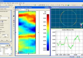
Surveying Statistics, Part 1 Do you perform GNSS surveys? Do you use OPUS or perform RTK surveys simply because you don’t understand your software’s output? Do you always use the compass-rule adjustment for traverse data simply because that’s the way you have always done it? Do you ever have a situation where you know something...

A Global Geodetic Roadmap
Above: Ambassador Peter Thomson, Fiji’s permanent representative to the United Nations, presents to the General Assembly the resolution titled, “A global geodetic reference frame for sustainable development.” The United Nations takes up the call to develop a global geodetic reference frame for sustainable international relief and development. Geospatial technologies that have quickly become commonplace and essential in industrialized...

Proving Ancient Measurement Methods
Surveying students calculate the Earth’s circumference by following Eratosthene’s method, with help from modern sources. As part of the Geodetic and Control Surveys class at Dunwoody College of Technology in Minneapolis, Minnesota, we have been studying the history of Eratosthenes and how he calculated the circumference of the Earth. As a class we decided to...
Time to Do More
xyHt has been watching a recent flurry of news releases and webinar announcements from Trimble tagged with the slogan “Time to Do More.” There were quite a few major new products and enhancements announced so we wondered: Was this simply a marketing campaign? Or was this some new direction for Trimble? We decided to ask...
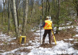
Mapping the Appalachian Trail
How the AT was created and surveyed, from Avery’s wheel to GPS The Appalachian Trail (AT) is very old, very long, and iconic. Completed in 1937, it stretches 2,189 miles through 14 states, 88 counties, 168 townships, eight national forests, six national parks, two national wildlife refuges, and more than 65 state game lands, wildlife...