Category Archives: Surveying
The Right Right
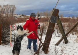
Igor Kidinsky thought about another career for a fleeting moment. His cold fingers struggled to fine-tune the total station. As an Afghanistan war veteran, he sometimes dreamt of spending his life closer to a beach rather than continue freezing in the mountains. He would leave his crew-name of Eager (the Kid) behind and put his...

Transformation of Observations, Part 4
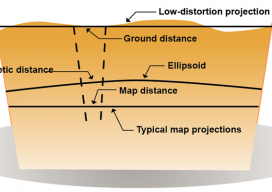
Single Project Factor Here concludes a four-part series of articles about transformation of observations, spanning from September and December 2014 to March 2015. Part 1 covers how to transform surface observations into a geocentric coordinate system so that they can be compared to GNSS baseline vectors. Part 2 is about how the creation of a...
RFID
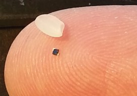
Above: RFID tags take many forms. The inside of a tag shown above—designed to attach to metal infrastructure in harsh environments, such as water pipes and valves—has a thin copper “bow-tie” antenna with a minuscule chip in the middle. It’s shown contrasted with a grain of rice. An electronic handshake has brought together the worlds...

Mapping Peripheral
A review of Trimble’s R1, a GNSS Bluetooth peripheral for mobile devices, with multiple options for correction sources. The idea of a GNSS “puck” has broad appeal: a peripheral GNSS receiver to precision-enable mobile devices such as smart phones, tablets, and a variety of purpose-built field-data-collection devices. There is a lot of functional territory between...

Maximizing the Sun
Solar energy grows in part due to aerial imaging and surveying. Solar power is booming in the United States. “Every three weeks,” President Obama said in his 2015 State of the Union address, “we bring online as much solar power as we did in all of 2008.” Geospatial technologies—especially remote sensing and surveying—play an important...
Single Transformation with ECEF
We at xyHt think this topic is one surveyors should be talking about. Instead of placing this reader’s letter to us as a comment under Dr. Ghilani’s article (linked below), we are making it a post itself to encourage discussion underneath. Editor Gavin Schrock, PLS, started us off, below. Professor Ghiliani’s article, Transformation of Observations...