I took a new GPS mapping receiver out to the field for a test drive and found out that it is also a full GNSS survey rover.
GNSS mapping peripheral-maker Bad Elf recently introduced a full survey-grade rover—and a unique pricing model. Surveyors might not be familiar with the name Bad Elf, but in the world of GIS and field asset mapping, their small GNSS peripherals are quite popular. Folks are out mapping trails, inventorying utilities, delineating wetlands, etc. with their gear—in the precision realm of sub-meter to several meters. But now Bad Elf has stepped up to the realm of centimeters.
I’ve had one of their clever little “pucks” for years. These devices are standalone GPS receivers with a simple display, but they are most popular as a peripheral for mobile tablets (or even phones) running mapping apps, like Esri Collector. Their “pucks” come in three tiers, from autonomous solutions to SBAS-enabled up to multi-constellation GNSS RTK-corrected. These devices connect to your phone or mobile tablet and feed in the improved positions to whatever location-based app you are running, even Google Maps.
During a 2017 visit to Bad Elf’s HQ in Scottsdale, Arizona, I asked Larry Fox, VP of marketing and business development, if/when Bad Elf would venture into the realm of higher precisions. His response was just a big smile. Two years later, the Flex was announced.
Form Factor
The Flex does not look like a typical “burger on pole” survey rover.
Fox says the form factor was deliberate, to provide more flexibility for various types of mapping as well as surveying.
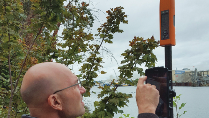
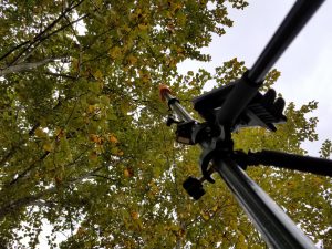
The new Bad Elf Flex is a survey-grade rover as well as a mapping peripheral. Operated from phones, mobile tablets, or data controllers using mapping or surveying apps, it also has an onboard display: here showing RTK results and its electronic bubble.
It is tall and narrow, about the size of large spray paint can. The lower two-thirds is a solid alloy housing, and the top is a plastic cover for the helical antenna. “We were looking for a particular form factor,” said Fox when he brought one to town for our test drive, “but we wanted performance. We tried a lot of helical antennas, and this one was amazing. We looked at smaller ones, but it needs to be this size to get all the bands and mitigate a low horizon—there are size and diameter limits.”
The antenna fits the overall form factor well. When the plastic cover is removed, you can even unscrew the helical antenna, and there is a standard SMA connector you can attach a coax cable to for an external antenna, if desired.
One of the many reasons for the form factor was feedback from users of traditional pole-burger rovers. Some folks, in the course of mapping, tend to push the limits of their rovers, like pushing the pole up through vegetation or branches to get more sky; the sleek shape will make that easier.
“Users will be doing high-precision work, like surveying, with the Flex and lower-precision mapping. We needed to make it flexible for all uses,” Fox said.
The charging/data jack is a USB-mini, which is less prone to breaking than USB-micros. You can use it for charging even while operating. The housing opening for the USB socket is standard, so one could potentially put in a different one if desired, like a USB C type.
There are flexible mounting options. On the bottom (the ARP) is a 5/8-11 brass socket for any standard pole or tribrach. An adapter for -20 thread is included, plus another -20 socket on the side of the unit. The Flex is IP57-rated and has a 12,000mAh battery. You can use any charger. A full charge may take between six to eight hours. If you are running it in RTK mode it should last 11 hours on a charge; if using the L-Bad PPP it might be eight.
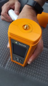
The helical antenna and cover can be removed to attach an external GNSS antenna, if desired, via a standard SMA coax connector.
I like the new trend in survey gear where you do not have to deal with proprietary batteries and can connect a standard battery bank any time you need more juice. Connectivity to a data controller, tablet, or phone is via Bluetooth (the WiFi module has not been tapped yet), but the USB data port opens up other possibilities. I could envision streaming RTCM3 corrections out to, say, a low-cost radio (like some Ubiquiti PicoStation 2.4GHz radio pairs I use for monitoring sensors) for base-rover usage. While RTCM3 is a standard output for the Flex, Fox says they have not pursued base-rover operation modes (yet). I have a sense that the Flex will continue to evolve
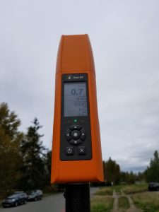
The Flex has a built-in monochrome display, with standard status screens. While you might be using it with mapping software on a phone or tablet (e.g. with Esri Collector) or survey software (e.g. MicroSurvey Field Genius Android) on a data controller or tablet, the display up on the pole is handy for checking things like PDOP and other quality indicators. The Flex has an electronic bubble, not tilt compensation, but it’s still very handy.
The built-in display is what Fox calls “transflective; it can get brighter in sunlight.
Many field displays are standard TFT (LCD) and those are power hogs. Transflective is widely used; some are even in color. The power draw is very small, much less than the backlight. We wanted to be consistent with our full product line and have built-in displays, and we are working on leveraging the display and color status lights to indicate, for instance, when certain quality thresholds are met.”
The Flex includes a companion app compatible with iOS and Android. It enables you to manage settings and configuration, purchase and load tokens (credits), set up the NTRIP client, do firmware updates, and do raw logging for post-processing.
A unique aspect of the companion app has a lot to do with apps in the Esri ecosystem. On iOS, apps like Collector for ArcGIS benefit from full GNSS metadata. On Android this is not the case. Bad Elf built their app so that on Android, the app can both stream corrections and allow other direct-connect-style apps to get the full connection so they can record GNSS metadata. The short story is most apps on Android block the Bluetooth connection so only one app can talk/receive at a time. The Bad Elf app removes this limitation.
Why does this matter? GNSS metadata is a necessity when recording high-accuracy features with direct-connect apps like Collector. Having the accuracy readings, DOP values, and receiver information tagged with features is important to the QA process. You can also tell if the solution was differential, float, or fixed.
The Flex is designed for a wide range of uses, from coarse GIS mapping, to mid-precision asset inventory to high-precision surveys. This means a range of users with varied experience in field practices. Fox explained that Bad Elf has put a lot of thought into workflows for the Flex and using the status indicators and display to guide the user in evaluating quality.
The Flex is four-constellation: GPS, Glonass, Galileo, and Beidou, plus it can receive L-Band PPP (i.e. Hemisphere’s Atlas). It can also utilize external RTK or real-time network (RTN) corrections to yield centimeter precision. Map, survey, navigate … a unique pricing and services model make it flexible for any of these uses and lets you try different approaches to funding your hardware.
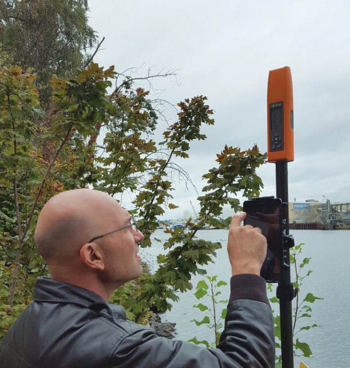
Bad Elf’s Larry Fox brought a new Flex rover to town for a day of test driving. It performed as well as a high-end survey rover in a variety environments.
Buy or Bill?
You can buy the locked model for about $2,500. That gets you autonomous and SBAS (e.g. WAAS). With WAAS you can typically get 40cm-60cm, and in clear sky conditions as good as 20cm-30cm.
You can also pay as you go for the higher precision augmentation. Instead of major outlays for hardware, you can choose a low entry price and then buy credits—that you could bill to projects. The credits are about $25 per day. The Flex keeps track of the usage, even if you are not connected to the internet.
You can drive all the way out to a remote jobsite, and start the clock ticking on a 24hr credit when you actually start the work. Access to the Atlas global PPP service is live when you activate a credit. Atlas can yield, after a 10- to 15-minute initial convergence, 4cm-6cm (horizontal). But you can also then connect to local/regional RTK sources or RTN (those may be free or for-fee) for centimeter results. This could be a good option for occasional use, or if you plan to bill usage to projects. The legacy of surveying and mapping gear is to capitalize it, but for instance in construction we see more and more leasing/rentals.
New practitioners in the field, having grown up in the “subscription economy,” may be much more inclined to choose such options.
The other option is to buy the unlocked version for about $5,000. This could be good for users who prefer to capitalize their hardware. You can use external RTK/RTN sources, and/or pay for L-Band PPP (Atlas) separately. By the time Fox finished explaining to me these options, it obviated my planned question as to why the named this new unit the “Flex.”
Test Drive
Fox stopped in town recently for a day of field tests. As I always do when test driving field GNSS gear, I take shots on two or more marks on a National Geodetic Survey (NGS) calibration baseline and compare inverses to published values. And I take along a recent-model high-end survey rover.
We connected to the Flex (via a mobile tablet) to a local RTN for RTCM3.2-MSM corrections. It fixed as quickly as the other rover. PDOP and quality indicators were the same: about 1cm horizontal by 2cm vertical. The inverses, though, averaged out to 5mm, just as good as the rover (and other units I’ve tried recently on the same baseline).
Both the Flex and my other rover struggled in thick canopy but had no problems in moderate canopy.
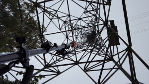
In my favorite “multipath hell” test location, under a transmission tower. The Flex was actually able to get a fix where a different high-end rover was not able to. Poor results, but still a fix.
The other unit was not enabled for Beidou, and in one instance the Flex, with Beidou on, was fixing where the other could not. One of the misconceptions about helical antennas is that without a large ground plane they might not be able to deal with multi-path well, but there are many ways to address multipath. Our first multipath test, working close to a tall vehicle, showed no weakness, and when we tried my favorite “multi-path hell” test spot under a transmission tower, it actually fixed for a short period. It achieved ugly results (6cm horizontal), but it did get a fix—the other did not.
We took some observations at other locations around town representing various other typical field environments. To test vertical performance, we checked into (recently published) NGS benchmarks and were matching between 15mm-25mm. (Perhaps this is also a testament to how well the local RTN is constrained to the NGS CORS in that area as well.)
The Flex did as well in various sky-obscured locations as a different high-precision survey rover tested at the same locations/day/time. Both struggled in very thick canopy.
Fox says that the IGS/NGS antenna models are in the works (e.g. for standard post-processing and NGS OPUS). The native static format is binary (but there are converters for Rinex), and Fox said that he would like to see Rinex offered natively at some point. One key lateral development is the recent launch of the Android version of MicroSurvey’s Field Genius survey software (see our companion profile of MicroSurvey). Support for the Flex has been added in Field Genius. This kind of collaboration, among developers of field software and hardware, and rapid rise rise of many emerging/evolving manufacturers, exemplifies the current 4th Wave of GNSS rovers, and other surveying and mapping instrumentation.
Yep, Bad Elf has upped their game with a new rover that adds to their mapping portfolio, but they have now also opened up a whole new surveying portfolio. It is a bona fide survey-grade unit (that does not snag as much in vegetation like the standard pole-burger rovers). And with a very interesting pricing model.
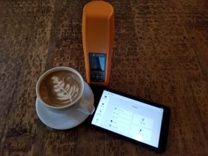
In keeping with tradition when I test drive rovers at the National Geodetic Survey calibration baseline near my home, we stopped to debrief at an adjacent coffee house (Zoka, a college hangout and Seattle icon) and take a photo with a coffee cup to demonstrate the size of the rover. The Flex is about the size of a spray paint can—a bit smaller and heavier—and the user can run whatever compatible surveying or mapping software they choose (e.g. Esri Collector, MicroSurvey Field Genius) on any number of mobile tablets.
#4thWaveGNSS #4thWaveSurveyingInstruments #4thWaveGeomaticsInstruments