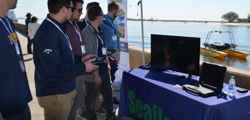
Students watch a pier demonstration—back row, l to r: Clayton Harbin, Troy Peterson, Max Crowe, and Jack Jamieson from NW Michigan College and Casey O’Heran from University of New Hampshire. In front is JT. Myers, an ocean engineer at Seafloor Systems.
Highlights from the U.S. Hydro 2019 Conference
The U.S. HYDRO 2019 Hydrographic Society of America conference, co-hosted by National Geospatial Intelligence Agency, was the 17th biennial event and took place March 18-21, 2019 in Biloxi, Mississippi. Its content was balanced among public, private, and academic entities presenting their work in hydrographic surveying.
The conference kicked off with a series of workshops on day one, which was followed by two and half days of presentations. This year’s conference theme was “Our Changing Oceans and Coasts: Driving Innovation in Charting.” The event consisted of 92 exhibit booths; many technical, lightning, and poster presentations; pier exhibitors/demonstrations; social events; and a silent auction.
To me, every session was intriguing and well planned with few overlaps between them. I had to sacrifice a few of the technical sessions to attend some of the pier space demonstrations, but the conference had diligently recorded all the sessions so attendees can watch what we missed on their website. The conference was well attended by more than 600 people, with 90% from North America and 5% from Europe and Africa.
Mike Nitska, THSOA president and conference organizing chairman, said, “I am pleased to say that this was the largest US HYDRO conference in terms of attendees and exhibitors. With technology changing at a very fast pace, the exhibits and technical presentations were on the leading edge of this change. With the current professionals maturing in age, it was very encouraging to see high school and university students attending the conference as they are the future of our profession.”
ASVs
The technology with a significant presence was unmanned hydrographic surveying solutions. (They’re called variously autonomous surface vehicles (ASV), unmanned surface vehicles (USV), drone boats, and robotic vessels; I call them ASVs).
These autonomous solutions carry various payloads including cameras (optical and thermal), visual systems, sensors, echo sounders, SONARs, X-band marine radars, and lidar. Integration of multiple payloads on such systems has significantly enhanced ASV capabilities for bathymetric surveying, ocean mapping, long-term environmental monitoring, and maritime security applications.
Based on their capabilities, they range from a simple kayak design for shallow waters, to a popular catamaran style for deep water, to semi-large autonomous vessels for longer-range and endurance surveying applications.
The growing interest for ASV in the surveying community lies in the fact that they have a substantially lower cost to operate compared to conventional hydrographic surveying operations. I am seeing several traditional land surveying firms expanding their portfolio to include hydrographic surveying services with the adoption of this emerging technology.
According to the Research and Markets 2018 study, the ASV market will continue to grow from current estimates of over half-a-billion to a billion dollars by 2023 at an annual growth rate of more than 14%. Critical factors driving this growth are the need for accurate mapping of our oceans and maritime security. These vehicles’ greater autonomy and longer endurance will continue to propel this growth exponentially.
Software Demos
The usual suspects in hydrographic survey processing software—Xylem, HYPACK, Teledyne, CARIS, and QPS—were demonstrating new data acquisition, fusion of disparate data, and processing capabilities. The focus was on software support for autonomous vehicles, and data fusion with terrestrial and aerial systems for seamless integration of data at the land/water interface.
Last but not the least, Esri, the leader in GIS software, demonstrated various ArcGIS extension modules for display and analysis of rich hydrographic surveying data. Lee Briton, 3D technical consultant at Esri, demonstrated a simple web-based GIS application that was accessing a multibeam point-cloud dataset with more than 10.6 billion points streamed from an offsite location using their cloud-based services. They are currently working on a robust contouring algorithm to handle multiresolution datasets to support their electronic navigation charting and bathymetry modules. Some of their existing ArcGIS extension will be migrated to their new release of ArcGIS Pro for better 3D visualization later in the year.
Online Training
Another presentation that caught my eye was from IIC Technologies, proposing a blended online delivery of educational and training courses for students and working professionals who are geographically displaced. The goal of this approach is to create an academy with access to expensive infrastructure (equipment, operations, etc.) and subject-matter experts in the areas of hydrographic survey data acquisition, processing, database services, data validation and maintenance, and navigation services.
This will minimize the cost for both the provider (educational institution or training institutes) and the students to achieve their educational requirements. The goal of the academy is to develop a tailor-made curriculum that will satisfy CAT A or CAT B certification requirements and meet all the accreditation standards.
This set of courses will be a great opportunity for any existing land surveying and geomatics program in the nation to jump start a concentration in hydrographic surveying.
Student Outreach
As an educator, I appreciated the amount of effort put forth by the hydrographic society for student outreach during the event to recruit and introduce students to the hydrographic surveying profession. The society had sponsored nine undergraduate and two graduate students nationwide to attend this event with all expenses paid. They had also reached out to local high schools to bring students for a tour of the exhibit hall. This is a great way to introduce high school teachers, counselors, and students to the hydrographic surveying profession.
I saw lot of excitement and enthusiasm with which students interacted with the exhibitors displaying their drone boats and various sensors. Their eyes lit up at the software and 3D virtual reality headsets depicting underwater mapping datasets.
I believe (and everybody I know agrees with me) that there is a real need to replenish the aging workforce due to retirement and new requirements from technological advancements in the profession. I left the conference with the hope that I will be followed by these younger and technologically savvy kids entering the profession.
I am already looking forward to U.S. HYDRO 2020 to be held at Quebec City, Quebec, Canada.
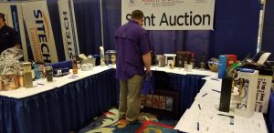
Conference attendees bid at the silent auction during the conference.