August 2019 Archives
UAV Stakes Out New Ground
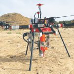
Above: A prototype of the Civdrone UAV preparing to drill a stake into the ground. A flying/staking robot has taken a huge step forward in automation for site layout, including road, rail, utilities, and energy applications. Working the traditional way, how many surveyor-days would it take to mark the 300,000 points needed to lay out a […]
Inexpensive Does Not Mean Cheap

A revolution is happening in affordable surveying and geospatial instruments and solutions: high-precision positioning has become much more accessible and affordable for existing and emerging end-user constituencies. Many folks may have found high-precision prohibitively expensive in the past or were resigned to low-precision choices, but now there are a lot more solution developers, manufacturers, and […]
New GNSS Kids on the Block
Test driving a new Tersus rover: There is more to the story than a $3,000 price tag. The advent of a $3,000 high-precision GNSS rover holds a certain appeal, even more so when a test drive reveals that it holds its own with top-end rovers in many ways. But there is more to this story […]
Automated City Extraction
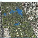
Above: A portion of New York’s Central Park and surrounding neighborhoods, as automatically parsed into GIS data and reconstructed into 3D models by Geopipe. A new company called Geopipe builds 3D models using machine learning and AI, but with no photogrammetrists? A couple of weeks ago I found myself on a video call with a […]
6D SLAM

An indoor spatial intelligence start-up from Germany is pushing the BIM industry forward through a combo of navigation and visualization. The line of people at the Intergeo Trade Fair in Frankfurt, Germany, waiting to get their hands on the NavVis M6 was long. Where everyone was on the lookout for the latest geospatial products on […]
Harnessing Drones the Photogrammetric Way

Above: The Inspire 2 drone, using a Zenmuse X7 sensor and 16mm lens, captured this high-resolution image of County Line Road in Beavercreek, Ohio. Credit: Woolpert. Considering that UAS are just another platform to carry sensors, new mappers should embrace merging photogrammetric techniques and practices with innovations by the computer-vision community to produce scientifically sound […]