June 2017 Archives
Point A to Point BIM

Our publication is all about how to get from (or measure between) point A to point B: the processes, tools, software, methods, and professional spatial judgments that go into these actions. Sometimes the road between A and B has a lot of twists and turns, and in the case of moving design and construction from […]
“Next Big Thing” Essay Winner: Bring the Old and New Together
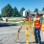
Bring the Old and New Together The next big thing for the surveying profession is much more than a new instrument or the use of a new technology. To me, it is something much more profound than that. I recently read a statistic in an article printed in the Gem State Surveyor, the quarterly publication […]
The Hydrous: Mapping Vanishing Reefs

Using geospatial technologies, The Hydrous provides “open access” to oceans in an attempt to save critical habitats. The oceans of the world are vital to our survival. While monitoring their health is the realm of scientists and protecting their health is the responsibility of everyone, few of us truly experience the richness of these aquatic […]
Mapping Rwanda: Surges Forward in UAS Mapping Use
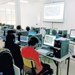
From cadastral to precision agriculture to humanitarian aid, UAS are making a big difference while mapping Rwanda. (Above: Course participants examine an orthomosaic in Pix4Dmapper during software training.) After Rwanda made waves in the news early last year for allegedly being the first country to approve drone delivery, people payed attention. The country, with its rolling […]
Mapping the 1874 Yavapai-Apache Exodus Trail
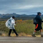
Modern hikers map the Exodus Trail of the Yavapai-Apache Nation with GPS. By Everett Phillips, Philipp Hummel, PLS, and Bryan Frazier; introduction by Judie Piner In 1875, both the Yavapai and the Apache people were removed from their Rio Verde reservation in Arizona and force-marched by U.S. soldiers in terrible conditions, nearly 200 miles, to […]
Surveying a Mile Down
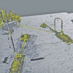
Above: The metrology viewed as a combined model. A 3D surveying company provides highly detailed lidar data on subsea drill centers. This article almost didn’t happen. I first met with ADUS DeepOcean in January 2017, when we discussed how they had captured high-resolution laser data deep in the ocean off Ghana. Today, four months later, I […]