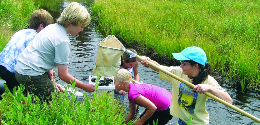
Above: Middle school students collect macroinvertebrates in Rocky Mountain National Park. The data will be mapped and analyzed using a GIS. Credit: Joseph Kerski.
Where did you first learn about GIS?
Was it in a course at a university or a community college? Were you an undergraduate or graduate student? Was it at a conference, or online, or maybe during a conversation with a relative or friend? Or, did you first learn about GIS in primary or secondary school?
For most people, the answer to that last question is “No.” But what if you had learned about geotechnologies way back in those early school days? Think of where you might be now if you had been using GIS since when you were, say, 10 years old.
While the use of GIS in primary and secondary instruction (or “K-12 education” as it is referred to in some parts of the world) is still not commonplace, it is a growing phenomenon. This trend is not just turning heads in the USA, but in Canada, Colombia, the UK, Taiwan, New Zealand, Australia, Germany, Belgium, Spain, Turkey, the UAE, Japan, and many other parts of the world.
Why Is GIS Growing in Schools?
What are students doing with GIS? And why are educators interested in using GIS in primary and secondary schools?
GIS is increasingly seen as a tool that can help schools:
- embrace the idea of teaching in interdisciplinary ways and in a manner that promotes problem solving, inquiry, and critical thinking,
- increase students’ access to STEM (science, technology, engineering, and mathematics) education,
- connect students to meaningful careers, and
- help “bring back” fieldwork in a technologically rich way.
Technical advancements have also helped increase an awareness of GIS in schools.
Web-based tools such as ArcGIS Online and web mapping applications such as story maps and 3D scenes have greatly reduced the technological hurdles faced by the “early adopting” teachers who were using GIS beginning in the 1990s. Not having to install software in dedicated high-end computer labs and being able to access GIS from any device, anywhere, at any time, have greatly aided adoption.
Perhaps most significantly is that GIS is slowly becoming written into national and state educational content standards. It is difficult to overstate the importance of being included in standards: What is included is tested, and what is tested is taught.
GIS implementation in primary and secondary education has been aided by other important developments as well. Providing free and open access to ArcGIS for every school in the USA and elsewhere was an important first step. The National Research Council’s 2006 report, Learning to Think Spatially, made a strong case that spatial thinking needs to be taught frequently and rigorously at all levels of education.
Building a community of educators who share ideas and best practices has been an ongoing effort of my own education team at Esri and by others over the past 25 years, through webinars, networking in GeoNet and elsewhere, contact at major educational conferences and at the Esri Education GIS summit held every summer, and through professional development events such as T3G (Teachers Teaching Teachers GIS).
An increasing amount of data that educators could use as a result of the open data movement, manifested in such portals as the Living Atlas of the World, has been another important advancement. Easy-to-use field apps for the smartphone such as Survey123 allow educators and students to collect data in the field—even on their own campus.
The development of a body of lessons that educators can easily use in the USA, the UK, Australia, and elsewhere is another factor hastening the infusion of GIS into K-12 curricula.
Finally, the ability for educators and students to create multimedia web mapping applications such as story maps provides a communications tool for students and an assessment tool for their instructors and helps blaze trails to mapping in non-geography and non-STEM disciplines.
Schools Using GIS for Schools
Just as important is making sure that the planning, operation, and protection of school districts, campuses, and the people they serve (students and their parents, teachers, staff, and principals) is paramount. GIS helps determine school attendance boundaries, campus locations (new ones and those needing to close), efficient bus routes (consider the task of routing 250 buses every day to pick up and drop off 10,000 kids, for example), classroom and facilities capacities, emergency plans and evacuation routes, and much more.
In an era of limited education budgets and staffing, GIS provides a set of valuable tools—even down to the interiors of buildings.
Implementation Challenges
Despite these developments, challenges still exist in implementing GIS in primary and secondary education. Since I worked for years at the US Geological Survey, allow me to provide a geologic simile: a conglomerate.
The cobbles and boulders in the conglomerate can be thought of as disciplines that are important to the geospatial industry, such as computer science, geography, mathematics, and others. Most of the general public could probably describe a little something about them to some extent.
But geospatial technologies and spatial thinking, in my view, are like the sand in that same conglomerate. Even for educators, these concepts are difficult to define and to grasp—they slip through the fingers. What is being learned when students use GIS? Can these skills be tested? While difficult to grasp, geospatial technologies touch and are important to all of the disciplines represented by the cobbles and boulders. Because geospatial tech is by its nature interdisciplinary, it is challenging to shoehorn it into one specific course at the K-12 level, and this is one reason why it is not often taught or emphasized.
But things are changing. In the USA, around 7,000 schools have an ArcGIS Online organizational subscription, in part thanks to $1B in grants Esri has provided. They make free ArcGIS online accounts available to all U.S. elementary, middle, and high schools as well as home schools. The software runs on cloud infrastructure provided by Amazon Web Services. While this represents less than 10% of the 110,000 schools that exist, the number of K-12 subscriptions is up tenfold from just a few years ago.
Around the world, GIS is implemented in many different ways, as my colleagues and I discovered in a book we wrote. In some countries, GIS is firmly anchored in environmental studies and fieldwork, while in others it’s rooted in CTE (career and technical education).
In a high school I visited recently, GIS was being used in programming (the ArcGIS API, JavaScript, and Python) and in animation and filmmaking courses (Esri’s City Engine).
Most GIS at the primary and secondary level around the world is taught as a tool in established disciplines such as geography, mathematics, biology, language arts, and many others—even art and physical education. In a smaller percentage of schools in the USA, such as the Geospatial Semester in Virginia and the EAST initiative in Arkansas, and even more commonly in other countries, teachers teach about GIS in geomatics, GIS, or geotechnology courses.
And in still other schools, GIS is used in after-school clubs or as a research tool for senior capstone projects. GIS is used in urban schools such as Roosevelt High School in Los Angeles, rural schools, and everything in between, from wealthy to poor neighborhoods. These schools have two things in common—teachers who are given the freedom to try new methods and students who are permitted and encouraged to fly.
Bigger Picture
Whichever way GIS is approached, I submit that there are three important things that students are learning:
- content knowledge, such as the interaction between humans and their environment, the hydrologic cycle, and other fundamentals;
- skills, such as oral and written communication, multimedia, working with data, and geotechnology; and
- the geographic perspective—a way in which space and time are considered. This is the whys of where—and encourages the students to consider, “Why should we care?”
Students are not “just learning how to push buttons” or “just learning how to run GIS software” but rather they’re learning to think.
Let’s step back a moment and ask: Do we think it is a good idea for young people to be using GIS?
If we want to enable a geospatially literate society in which decision-makers will consider the “where” question in their day-to-day work, I submit that, “Yes, we should be using GIS in primary and secondary schools.”
Need another argument? Given the energy, water, climate, crime, biodiversity, land use, and other challenges we are facing, I again submit that, “Yes, we should be using GIS in primary and secondary schools.” Given the increasing gravity and complexity of these challenges that increasingly affect our everyday lives, I believe it is imperative that we do so.
That said, I also submit that appropriate tools and approaches be used as fitting to the education level and setting of the student. For example, I observed a third-grade class in California where the teacher effectively taught about settlement patterns of the state using landforms, elevation, biomes, and population density as layers in ArcGIS Online, with one projector, in an engaging manner that met her educational goals.
I taught a middle school class international migration, change over space and time, and about cities using three different web mapping applications (the migration map on coolmaps.esri.com, the Change Matters viewer, and the Urban Observatory, respectively). Each group of five students shared (and rotated!) one Chromebook tablet and were engaged in these investigations for over two hours, answering questions I posed along the way and coming up with their own questions.
At the high school level, one science teacher brings his students to their local lake where they count birds and measure water quality, mapping and analyzing the results.
Other examples can be seen through the winners of the 2018 Esri Map competition and range from analysis of riparian resources, aquatic invasive species, the spatial pattern of basketball game attendance in Indiana, the history of U.S. steel in Morgan Park, Minnesota, the plight of the Blue Jay, disappearing wetlands in Louisiana, and many more.
As these examples show, GIS is used in a wide variety of ways and settings. Therefore, I do not advocate that eight year olds create data services and run spatial statistics, but rather for these tools to be used in grade-level appropriate ways that will interest students about their communities and world and that will meet goals that their teachers and schools have for them.
Think of the workforce implications if every young student is engaged with using GIS throughout their primary and secondary years. Think of the changes that might need to be made in university GIS programs. Think of the societal implications if thinking spatially was the way of every decision maker, every day, on the job.
How can you get involved? Sign up to be a geomentor for a school where you live or for another school that may need your assistance in assembling data or curriculum implementation. Get familiar with GIS education resources that my colleagues and I frequently write about. Be an advocate for GIS in your local school district, community college, and university.
University? Yes, because even though GIS exists in nearly every institution of higher education, it has only just begun to spread to programs in health, business, engineering, data science, and others—but more about that in a future column. References and related links are in the online version of this article.
References
Baker, Thomas R. 2010. The history and application of GIS in K-12 education. Geospatial World. https://www.geospatialworld.net/article/the-history-and-application-of-gis-in-k-12-education/.
Milson, A., Demirci, A., and Kerski, J. 2012. International Perspectives on Teaching and Learning with GIS in Secondary Schools. Springer, 353 p.