Tag Archives: geospatial

xyHt Weekly News Recap: 04/08/2022
FIG Congress 2022 in Warsaw: Registration Now Open Gold Shovel Association to Become Part of Common Ground Alliance 3,500 Attend Amsterdam Drone Week URISA Accepting Nominations for the GIS Hall of Fame Australian Firms Deliver High-Resolution Hyperspectral Earth Observation Microsatellites CoreLogic and EagleView Enhance Claims Processing Automation Quanergy 3D Lidar Flow Management Solution Deployed to...
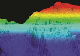
NOAA Advances Deep Channel Topobathy Lidar for Groundbreaking Alaska Project
Steep and rugged cliffs, rocky shores, changing turbidity, underwater hazards, and unpredictable weather are some of the extreme challenges of mapping the coastline and waters surrounding Alaska. However, a new topobathymetric lidar project for the National Oceanic and Atmospheric Administration (NOAA) conducted by NV5 Geospatial is leveraging a state-of-the-art combination of advanced remote sensing technologies...

From Nadir to Oblique
From Buzz to Shush Fighting the drone of drones Drones are hard workers. But because of the noise they make, many people are not fond of them. In a recent survey in Europe, when people were asked about their main concerns regarding the prospect of drone services in their cities, respondents from six countries chose...
xyHt Weekly News Recap: 04/01/2022
Flood Protection Program Virtual Industry Day Set for April 21 Synspective, World Bank, and NDRRMA Assess Geohazards after Flood in Melamchi, Nepal Qualcomm, Trimble Introduce Meter-Level Location Accuracy for Smartphones India Undertakes Large-Scale Bathymetry Survey to Develop Coastal Economic Zone Intermap Supports Ukraine’s Ministry of Defense with High-Resolution Analytics CompassCom Announces the Launch of Compass.University...
xyHt Weekly News Recap: 02/18/2022
Riegl Instruments Used by Projects that Win MAPPS Geospatial Excellence Awards Geo Week Exceeds Expectations Trimble Introduces Catalyst GNSS LAND INFO Announces Updated 10m USA Countrywide Land Use Land Cover Mapping Dataset XMAP Cloud GIS Brings Government Flexible Working Closer to Home Sonardyne Launch Wireless Seabed Unexploded Ordnance Disposal Capability Fugro Joins UN Ocean Decade...
xyHt Weekly News Recap: 02/11/2022
SBG Systems Introduces its First Tactical Grade IMU on the Market New Commercial BVLOS Milestone – Longest Distance Allowed by FAA at 12 Miles Phase One Launches iX Suite for Seamless Aerial Mapping Workflow Vexcel Introduces MapControl SDK to Help Developers Integrate Aerial Imagery New Surveying and Mapping Textbook Available for Download Vexcel Announces Image...