Tag Archives: gnss
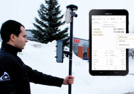
HAS Potential
Free and Global: The new high accuracy positioning service (HAS) of the Galileo constellation and its advantages for GIS and asset mapping If you consider field mapping applications, such as for GIS, asset inventory and management, and field operations for utilities, how wonderful would it be to have sub-foot positioning in real time, with no...

xyHt Weekly News Recap: 07/14/23
Bluesky’s Airborne Sensors Help Developers Protect Wildlife Habitats New Trimble Terra Office Workflow Delivers Integration with Esri ArcGIS Pro USGIF Announces Six New Board Members For 2023-2024 Topcon Introduces Aptix Integration Platform for Heavy Civil Construction Penn State Win Topographic Mapping at National Surveying Championship Tallest Mountain in Idaho is Higher Than Thought Registration Open...
xyHt Weekly News Recap: 06/09/23
Association for Geographic Information Partners with British Cartographic Society Bowman Acquires MTX Surveying Birmingham Creates Interactive Mapping Portal using Bluesky Tree Data Valmont Records Longest BVLOS Drone Flight on the Wings of T-Mobile 5G Applications Invited for URISA’s Vanguard Cabinet Commercial UAV Expo Announces 2023 Conference Program and Speaker Line-Up Commercial UAV Expo Program Released ...
The Responsibility to Map the U.S. Coastline
(And the Inevitability of New Geodetic and Tidal Datums) Since the arrival of the first pilgrims to the North American continent, there has been a need for precise knowledge of the coastline of the new country, and the reasons are obvious. Arrival by boat was the only alternative when crossing the Atlantic and escaping religious...
xyHt Weekly News Recap: 05/12/2023
Phase One Takes Aerial Imagining to Another Level GeoBusiness is Back for 2023 USGIF GEOINT Symposium Set for St. Louis May 21-24 Vexcel Offers Access to High-Resolution Imagery in Australia and New Zealand Neusoft and HERE to Provide More Competitive Global Navigation Solutions Trimble Introduces RTX Positioning Solution for Package Delivery Applications via Drones WGIC...
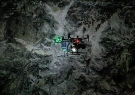
Autonomous Drone Mapping
How interior spaces like mines are being scanned and imaged by a drone that works without a pilot or connectivity. There is a scene in the Ridley Scott-directed 2012 sci-fi thriller “Prometheus” where a deep space exploration crew lands on a planet and discovers an underground labyrinth. They lob a levitating orb down a tunnel,...