Tag Archives: gnss
GNSS: The Archaeologists Tool of Choice
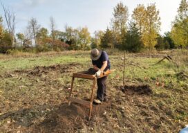
While we may want to believe that archaeology is a trade full of fedoras, whips, and mummies, you shouldn’t always believe what you see in the movies. That’s because when it comes to actual archeological projects, GNSS has emerged as the true tool of the trade. “Before GNSS, the archeological excavation process was both cumbersome,...

xyHt Weekly News Recap: 08/12/2022
New Tools Added to TDI-Brooks’ Shallow Water Geotechnical Kit RIEGL Contributed to Groundbreaking Multi-Enterprise LiDAR Benchmarking Study Registration for CONEXPO-CON/AGG and IFPE 2023 is Open New Addition to GNSS Smart Antenna Line URISA Announces Exemplary Systems in Government Award Winners URISA’s Vanguard Cabinet Announces the Results of the 2022 Student and Young Professional Digital Competition Geo...

An Exemplary Real-Time GNSS Network
For more than 20 years, SWEPOS has consistently demonstrated the full potential of real-time GNSS networks Standing in the main control center of Sweden’s real time GNSS network (RTN) system, I feel like I could be standing in NASA Mission Control. A marvel of infrastructure created by Lantmäteriet, the country’s mapping agency, the center has...

Refining Measurement
A land surveyor unpacks the concept of accuracy “Accuracy is addictive,” my friend David Doyle once said. Doyle is a geodesist by trade. For someone in his line of work, this addiction has a rich tradition. Geodesy is the study of Earth’s shape, rotation, and gravity field. The discipline involves an eternal quest to refine...
xyHt Weekly News Recap: 05/06/2022
NSPS to Host Virtual Town Hall on Davis Bacon Act Regulations LiDAR for Drone 2022 Conference Set for June 13-14 in France World’s First Expandable Wing UAS Launches at AUVSI XPONENTIAL Army Corps of Engineers Picks Aero-Graphics for Geospatial Mapping and Surveying High precision mapping and automated workflows IDS GeoRadar launches cloud-based AI solution AiMaps...

Street-Level Lidar On Demand
As exciting as the advent of on-demand access to current, high-resolution lidar is, so are the tools available for ingesting, extracting features, analyzing, and sharing. “What we’re hearing right now, this is really an inflection point for the industry,” says Phil Christensen, vice president for reality and spatial modeling at Bentley Systems. “The software has...