Tag Archives: uav

Drone Laws in Kenya
What to Expect in 2020 Drone enthusiasts in Kenya have been treated to a tumultuous love affair by the government. The affair started way back in 2015 when the craze for drones in various parts of the world caught on with a section of the Kenyan population. They started importing drones for commercial activities such...
Mandatory Drone Registration for the UK Looms
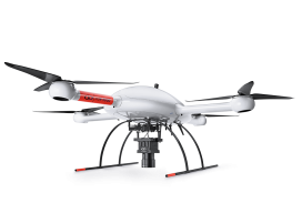
Operator ID Is Coming to the UK (Above is the mdMapper3000DµoG from Microdrones.) In the UK, starting November 30th, it will be mandatory for all drone owners [and model aircraft owners of drones/planes weighing more than 250g (8.8oz) up to 20kg (44lbs)] to register their details with the CAA (this is called an OperatorID). Owners of...

Esri Partners with 3DR to Launch the ArcGIS Drone Collection
New Partnership Offers Users Best-in-Class Drone Data Capture and Analytics Solution on the Market Esri, the global leader in location intelligence, today announced that it has partnered with 3DR, a leading US drone data company, to expand Esri’s current drone imagery offering, Drone2Map for ArcGIS, with an end-to-end enterprise drone data and analytics solution for Esri’s...

UAVs Enter the Sharing Economy
Above: A hypothetical Hangar mission plan for a city. A new platform connects UAV owners and UAV users while providing flight plans and image processing. As the UAV industry continues to grow rapidly, many companies are wondering whether they should own and operate their own UAV and, if they decide to purchase one, how they...

No Need to Buy to Fly
A startup took the idea of developing a complete sUAS workflow—hardware, software and processing services—and grew this into a premier sUAS rental/leasing service. Things move fast in the world of UAV/UAS/RPAS/drones. For example, DJI was just another UAV startup company when it was founded in 2006, and the name was not well known to the North...
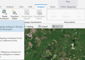
Using Ortho Imagery (Digital Aerial) in ArcGIS Pro
The new version of Esri’s ArcGIS Pro software offers the capability to use stereo imagery, something of great use to those looking to digitize and use 3D vector data. To this end, I thought I would try bringing in some stereo aerial data to see how the process works within ArcGIS Pro. Vague Knowledge At...