Category Archives: Spatial IT/GIS

Outlook 2020’s 40 Under 40
The following is xyHt’s 2020 collection of 40 under 40: profiles of motivated and accomplished young professionals under 40 years of age. Click on each name to view their profiles below. Kwabena Obeng Asiam Researcher & Lecturer – Leibniz University Published PhD candidate in land administration; FIG Young Surveyors Ghana Evaluating the evidence and making...

Mentoring’s Evolution in GIS
Having focused on the education side of geography and geospatial technology for much of my career, I’m focusing this discussion on mentoring in formal and informal settings: schools, after-school clubs, libraries, museums, community and technical colleges, universities, and adult learning venues. As geotechnologies’ needs, audiences, and expectations have evolved, mentoring has evolved, and (I would...

Container 42: So Smart it Knows All the Answers
Container 42 and digital twins: the answer to life, the universe and how the Port of Rotterdam is transforming infrastructure management and operations. Editor’s Note: If you think the term “digital twin” is yet another high concept being foisted on surveyors and geospatial professionals in AEC, then you are not alone. But you are hearing...
Hydraulics in the Cloud
The City of Durham prepares for growth by collecting and leveraging data through a web-based GIS—to create a hydraulic model for its wastewater collection system. Durham, North Carolina is experiencing a growth rate it has never before known, with more people moving in, per capita, than all but three other cities in the country. Durham’s...

Unity Reveals Reflect
Reflect by Unity is like … the gamification of BIM? Imagine you get an email message that reads, “We’re reviewing the Alderson building model. See you in 10 mins?” Seeing this, you take a large slurp of hazelnut latte and put on your VR goggles and hand grips. Suddenly, you are transported (digitally) inside a...
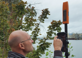
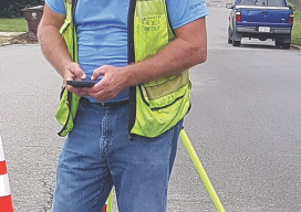
Flex! Bad Elf and Higher Precision
I took a new GPS mapping receiver out to the field for a test drive and found out that it is also a full GNSS survey rover. GNSS mapping peripheral-maker Bad Elf recently introduced a full survey-grade rover—and a unique pricing model. Surveyors might not be familiar with the name Bad Elf, but in the...