A Snapshot from the GeoDude on Rich Data
Here’s a comparison of today’s field and office efficiencies—for conventional surveying methods versus laser scanning—as applied to topographic and site surveys.
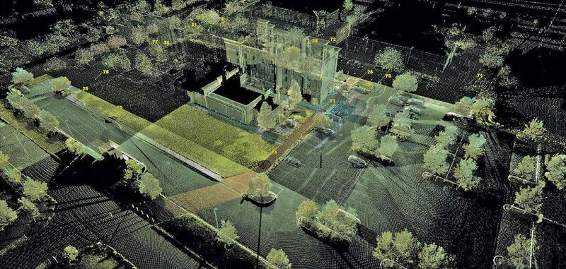
Above: The firm that used scanning for this site survey noted that more than 60% of these types of projects entail scope creep; scanning typically avoids go-backs. Credit: TheLandGroup.
Over the last 10 years, efficiency gains have been quite significant for conventional survey methods (total stations and GNSS) as well as for 3D laser scanning. This article addresses the question, “If we take a snapshot today, how do these methods compare in terms of field and office efficiency for experienced users and typical projects?”
In addition, scanning product vendors and service providers often cite additional potential benefits of scanning, such as a reduction in go-backs, so I dig into which, if any, of these potential “added-value” benefits are regularly realized today.
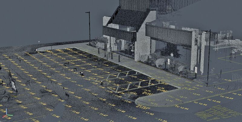
ADA and retail store site surveys both benefit from the added detail that scanning provides over conventional methods.
Credit: Control Point Associates.
Investigation Approach
In my research, I chose to interview experienced practitioners with deep project-estimating experience. As an example, one firm had used scanning on ~300 projects over the 6+ years that they’ve owned a scanner; 250 of these were topographic surveys.
Another user had applied scanning on ~250 projects over five years, 99% of which were site or topographic surveys. Yet another user has a large inventory of various model scanners (eight), including a mobile scanning system. They regularly do site and topographic surveys and also use scanning for BIM, highway, and other applications.
The scanners owned by these organizations were acquired between 2011 and 2016, and they’re a variety of scanner models suited to topographic and site surveys. (I did not interview users with special tall/telescoping tripods mounted in trucks, as those are currently considered specialty items often used for highway surveys, which are not the subject of this article).
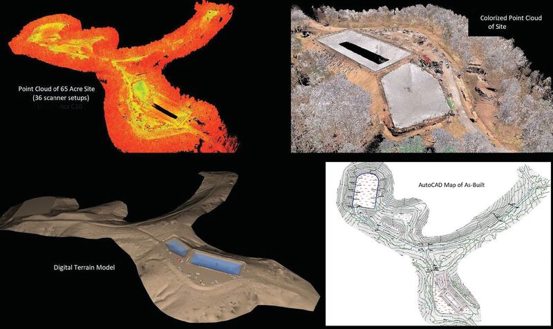
Scanning provided more
than 50% total savings in
labor over conventional survey methods for this 65-acre topographic survey.
Credit: Allegheny Surveys.
Specific Applications
There are many types of topographic and site surveys; below I’ve chosen several applications cited for productivity comparison examples, with comparative field and office metrics.
Remote natural gas well sites & access roads
This scope typically ranges from 10-22 acres per site, depending on access road length. One user explained that to capture a site with scanning involves a 2-person scan crew plus a 1-person RTK crew.
The RTK crew captures break-lines and culverts that can be difficult to capture with a scanner. With this crew, a 10-acre site takes 1 day in the field (including ~2 hours of travel each way). Field time includes taking pictures, later overlaid on scans for more realistic point cloud visuals.
For simple sites, office labor for scanning requires 1 office person-day for each field day; if piping needs to be detailed, then office time is 2 office person-days per field day.
Overall, for larger sites, total labor (field and office) savings with scanning was cited at 50% versus doing these convention- ally. For smaller sites, ~ 25% labor savings were cited.
For a recent 65-acre project, one user reported that his firm had done a detailed estimate comparing scanning with conventional methods. Total actual labor (field and office) using scanning was 108 person-hours versus an estimated 255 person-hours if the project had been done conventionally.
The user noted that scanning can effectively pick up ground surfaces through thickets and brush, thanks to the extremely high number of shots that are taken, more than enough of which make it through to the ground.
Other benefits cited for scanning were: a) much faster time to deliverable, thanks to fewer days in the field, b) the ability to create more detailed deliverables, e.g. surface models based on 3.5’ triangular sides extracted from scans versus 25’ sides using conventional data, c) avoiding go-backs, and d) safety—fewer people in the field for less time and less slope climbing.
Commercial ALTAs
The typical size was cited as 1-5 acres. The user I spoke with said they do 100% of these with scanning; basically, they use scanning for anything that includes a building.
In the field, doing these with scanning typically takes a 2-person crew (1 scanner and 1 RTK or robotic total station) 1-1.5 days. Conventional methods require a 2-person crew for 3 days, so they experienced 50%+ field savings for scanning. Both methods involve 1-1.5 days in the office.
Scan time included taking pictures to overlay on point clouds, primarily for presentations to clients and for general marketing purposes. Ancillary benefits cited included not having to go back to sites and a QA/QC benefit, both increasingly valuable for sites farther from the office.
School sites
Sites are typically 15-30 acres; using scanning to capture them requires 1 scanner person plus 1 conventional person for 3 days (6 person-days total). Doing these fully conventionally requires 3-4 people for 4-5 days, or anywhere from 12-20 person-days. In the office, both field approaches involve 1 tech for 3 days.
One major ancillary benefit was cited for scanning here: avoiding go-backs as project scope increases. This was not just the case for school sites. The user explained that more than 60% of their topo and site surveys wind up with scope creep! The original scan data typically supports these cases without having anyone go back to the site.
Land development/residential road surveys
The typical scope cited for these projects was 1-1.5 miles of 2-lane subdivision/country road. One user said doing this conventionally would take 3-4 days with a 3-person crew capturing data at 75’ station intervals. With scanning, a 2-person scan crew would take 1 day in the field, setting up their scanner every 250’, with 500’ between control points. Both scanning and conventional field methods would take an office tech .75-1 day to create final deliverables.
Safety was cited as a benefit here, noting that scanning exposes fewer field staff to traffic for fewer days.
ADA surveys for individual retail business
The user I spoke with noted that these types of ADA surveys typically involve store fronts, plus paths to parking and connection to public streets. Store fronts are typically 35’-50’ wide, with another 100’ to parking and another 250-300’ to the nearest public street.
Conventional field work would involve 1-2 people for a full day; with scanning (including taking photos to overlay on point clouds), 1 scan person can do 2 of these per day and start a third. In the office, converting scans to final deliverables typically involves 4-6 hours, while processing data collected conventionally only requires 2-4 hours in the office.
Ancillary benefits of scanning were cited as a major benefit for commercial ADA surveys. One was that, “You just get so much more information with scanning.” An example was cited where the original ADA design didn’t fit where it was planned; however, scan data was used to identify a viable alternate location without revisiting the site.
Another scanning advantage cited was being able to set up a scanner out of the main walking paths for retail customers, a significant customer convenience for the store owner. The ability to capture tighter surface grids with scanning was also cited as an additional practical benefit.
Malls
One user had recently done a mall survey using static scanning plus mobile scanning for part of the project. I asked the user, “What if you had done the project fully conventionally or fully with static scanning; what would be the comparative metrics versus the way you actually did it?” The project involved 35-40 acres and included a conventional boundary survey.
If the entire project had been done entirely conventionally, the user estimated 1.5 weeks in the field with a 2-person crew plus 7 total person-days in the office of 1 tech and 1 CAD person. If it had been done fully with static scanning (excluding the boundary survey), field labor would have been a 2-person crew for 1 week, plus 10 or so person-days in the office.
In reality, they did the field part of the project in 3 days using a combination of static and mobile scanning (1 day driving and 2 days static, including photos, to fill in where they couldn’t drive), plus 7 person-days in the office to create deliverables.
Standalone retail store sites
The specific example cited by the user I spoke with was for surveying McDonalds sites. As he noted, although the food is the same at every location, the sites vary a lot. He explained that McDonalds is revamping/modernizing landscaping of many locations.
Project metrics for using scanning here were not as compelling as for other examples. However, this was an example of where the ancillary or added value benefits of scanning often lead to a decision to use it.
In the field, such sites require 1 or 2 people for 6-7 hours using conventional methods. With scanning, 2 people would take 4-6 hours, including control. In the office, data collected conventionally requires about 6-7 hours to create final deliverables; processing scan data into final deliverables takes about the same amount of time.
The added value benefits of scanning cited included a) getting more detail, such as sign heights and shrubbery details (valuable for landscape redesign), b) getting a better DTM/not missing curb cuts, and c) safety benefits for busy parking lots and drive-throughs.
Scanning or Conventional?
The ultimate choice of which method to use also takes into account how each service is priced to clients. This article simply provides practical productivity examples for common applications. Often, scanning provides solid field efficiency advantages, while office times for the two methods are comparable. In many cases, the added value or ancillary benefits of scanning are also key factors in the final decision.
To read the rest of the articles in this print issue, click on the issue cover, below.