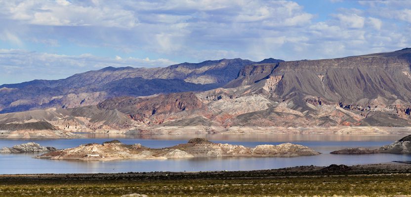
Image above: The Lake Mead region of Las Vegas, Nevada.
A project to identify and quantify irrigated landscapes in Las Vegas demonstrates the advantages of using lidar to save precious natural resources.
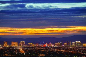
The skyline of Las Vegas where USGS 3DEP Quality Level 1 elevation data was collected.
Persistent drought conditions in the western United States are dramatically reflected in the steady diminution, over the past 15 years, of Lake Mead, the primary water source for the Las Vegas Valley, in Nevada. The valley includes Las Vegas and its metropolitan area, with a growing population currently totaling 2.2 million. It is the driest region in the United States, averaging less than four inches of annual rainfall.
The regional agency responsible for planning and administering water usage in the area, the Southern Nevada Water Authority (SNWA), was formed in 1991 by a cooperative agreement among seven local water and wastewater agencies.
In order to formulate a comprehensive water resource management plan, in 2016 SNWA hired Merrick & Company (Merrick), an employee-owned geospatial, engineering, architecture, and surveying firm, to collect and process lidar that would be used to identify and quantify irrigated residential and commercial landscapes. Following completion of the lidar, SNWA combined point clouds with other geospatial data to identify water-consuming vegetation.
Water Conservation
SNWA’s member agencies serve residents in the cities of Henderson, Boulder City, Las Vegas, North Las Vegas, and Laughlin, as well as areas of unincorporated Clark County. The region, famous for the Las Vegas Strip, is also known for its beautiful desert landscape, growing residential communities, and government and military facilities.
As the region’s wholesale water provider, SNWA is responsible for water treatment and delivery; managing and operating regional water facilities; acquiring and managing long-term water resources; and coordinating conservation programs for Southern Nevada. It aims to provide water service to its customers in a sustainable and adaptive manner through reliable, cost-effective systems in the driest region of the United States.
Southern Nevada reclaims and recycles nearly all water used indoors, returning about 40% of its water supply to Lake Mead. The remaining 60% of its overall water use is for landscape irrigation and evaporative cooling, making it the largest water-use sector in the desert community. Because this outdoors water use cannot be reclaimed or recycled, the community’s water conservation efforts have focused on reducing it.
As part of its efforts to manage existing and future water supplies in the face of persistent drought conditions in the Colorado River Basin, SNWA manages a water resource plan and comprehensive water conservation program. One of these conservation efforts includes the Water Smart Landscapes (WSL) rebate program which began in 1999. This program pays property owners to replace water-thirsty grass landscaping with drought-tolerant landscaping.
To support conservation, SNWA has invested in geospatial technologies to support scientific initiatives, advocacy, and public education efforts—including the use of high-resolution, 4-band (multispectral) aerial imagery, and remote sensing techniques to identify large grass and vegetation areas that may qualify for its WSL program.
Under the program, SNWA has so far converted more than 187 million square feet of grass to water smart landscaping, reducing outdoor water use and saving more than 119 billion gallons of water.
The Role of Lidar
To improve its ability to identify the large consumers of water such as residential turf and vegetation, SNWA integrated lidar into its remote-sensing analysis and retained Merrick to collect elevation point clouds over an approximate 1,162 square-mile area of the Las Vegas Valley and outlying areas.
Because lidar pulses penetrate vegetation and reach the ground, it has long been used to measure both bare earth profiles and canopy height as well as canopy density (the ratio of vegetation to ground as seen from the air). These data can then be used to calculate the biomass of the observed vegetation.
“Utilizing geospatial technology such as lidar enhances our water conservation efforts, affording us the ability to survey our valley and determine landscaping compositions that are water intensive,” said Judith Brandt, SNWA IT supervisor.
“With that information, we reach out to those properties and encourage them to participate in our conservation programs, such as our Water Smart Landscapes Program, which has removed more than 187 million square feet of grass and saved billions of gallons annually.”
“The SNWA water conservation program exemplifies the power of lidar and its benefits in the Western United States where drought conditions exist,” points out Doug Jacoby, Merrick’s project manager.
“The return on investment realized using high-resolution point clouds is quantifiable. Moreover, even greater societal benefits occur when data is shared by partnering local agencies and the federal government through the USGS 3D Elevation Program (3DEP).”
Merrick used an Optech Galaxy—a wide-area lidar sensor capable of 550,000 pulses per second that was one of the first of its kind at the time it planned and flew the project—and worked closely with Optech to assure that it performed to the intended SNWA and 3DEP specifications.
After post-processing, Merrick integrated the lidar- derived digital elevation models and hydro-enforced breaklines to facilitate identification and analysis of various types of vegetation.
The wide variations in natural and urban characteristics, which included man-made features in Las Vegas (Sphynx, rollercoasters, Eiffel Tower, pyramid, etc.), required Merrick to post-process the point cloud elevation data with special care in order to classify elevation points into the USGS LAS attribute levels.
Following the classification process, Merrick used its MARS software to create breaklines, which helped identify discrete geometric characteristics of man-made objects and important hydraulic drainage features found in a wash or arroyos that influence storm water runoff.
To correctly represent hydraulic drainage patterns, it was important to accurately map both types of breakline features. Moreover, correctly-drawn and hydro-enforced breaklines of these features enable engineers and planners to more accurately model water flow and volume computations as well as plan water-related infrastructure improvements.
Once that was completed, SNWA then refined the lidar model to further classify vegetation and trees into three height categories, which cannot be done with aerial imagery alone. Specifically, adding lidar to SNWA’s remote-sensing analysis will increase the accuracy of identifying vegetation from approximately 89% to 95%, greatly helping to identify areas where outdoor water use efficiencies can be improved.
Combining the many benefits of lidar data with the advantage of multiple agencies sharing costs and using the United States Geological Survey (USGS) Quality Level 1 and 2 3DEP, lidar specifications will provide improved insights to the project’s stakeholders.
Moreover, many local and federal users will be analyzing the same data, which could increase collaborative decision-making, reduce duplication, and provide higher value to citizens in southern Nevada.
Furthermore, the point cloud data will be used multiple times, greatly increasing the project’s return on investment. For example, the new lidar data will greatly improve existing digital elevation models, provide a framework for engineering of flood control channels and hydraulic modeling, and enhance geologic mapping by partnering agencies of known hazards throughout the Las Vegas Metro area.
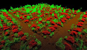
Final point cloud classified into ground, buildings, and three height categories.
The Project Team
Merrick completed the project using its lidar sensor and production capacity from its corporate headquarters in Greenwood Village, Colorado. The company holds a long-term aircraft operating lease with a Woman Business Enterprise firm named Aero Systems, Inc. of Erie, Colorado, that provides Merrick aviation logistics, dedicated Cessna 402C aircraft, and certified pilots. Because some of the funding came from a USGS 3DEP grant, the USGS also provided administrative and quality acceptance support.
In addition to administering Merrick’s contract, the SNWA performed the task of surveying lidar checkpoints, which were spatially distributed across the project areas, and the remote sensing analysis. Standards outlined in USGS National Geospatial Program LiDAR Base Specification, Techniques and Methods and ASPRS Positional Accuracy Standards for Digital Geospatial Data were required for the project.
SNWA surveyed a total of 265 checkpoints consisting of 61 non-vegetated vertical accuracy checkpoints and 204 vegetated vertical accuracy checkpoints. Additionally, the SWNA performed a rigid quality assessment of all Merrick’s deliverables.
The USGS National Geospatial Technical Operations Center conducted a quality acceptance testing of Merrick’s lidar acquisition and production processes and approved the SNWA lidar products for inclusion in its National Elevation Dataset.
The multiple uses of the data collected increased the project’s ROI and the stakeholders’ collaborative decision making. This “map it once, use it many times” strategy improved the outdated elevation models, infrastructure and flood control planning, hydraulic modeling, and geologic hazard mapping. The analysis to identify and classify trees and shrubs by height helps to reduce the outdoor use of water, conserving for it more critical purposes.